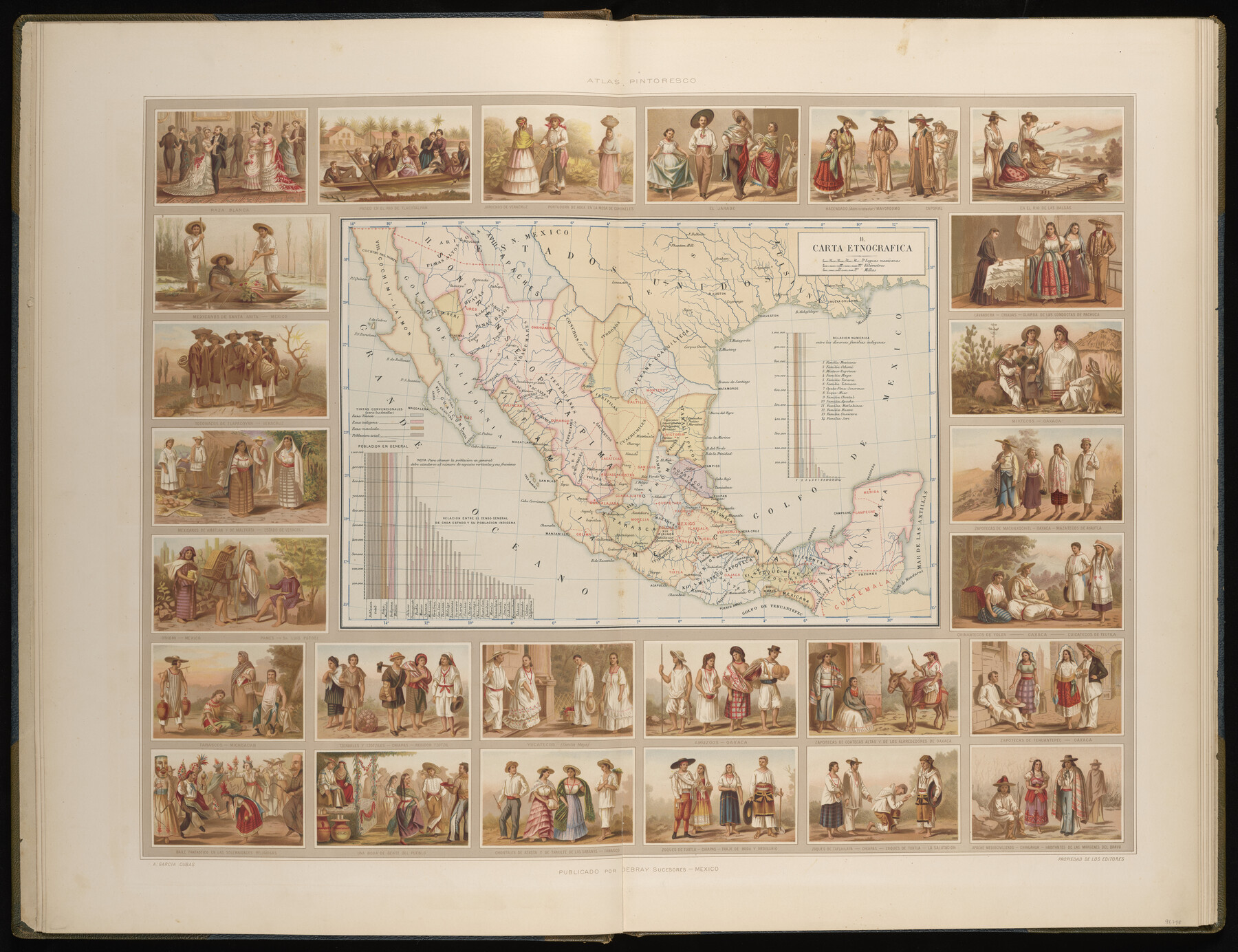
Carta Etnografica
-
Map/Doc
96798
-
Collection
General Map Collection
-
Object Dates
1897 (Creation Date)
-
People and Organizations
Debray Sucesores (Publisher)
Antonio Garcia Cubas (Cartographer)
-
Subjects
Atlas Mexico
-
Height x Width
26.2 x 34.1 inches
66.6 x 86.6 cm
-
Medium
paper, etching/engraving/lithograph
-
Comments
Map 2 of 13 from "Atlas Pintoresco e Historico de los Estados Unidos Mexicanos" (96796 - PDF)
Related maps
Atlas Pintoresco e Historico de los Estados Unidos Mexicanos

Atlas Pintoresco e Historico de los Estados Unidos Mexicanos
Map/Doc 96796
Part of: General Map Collection
Terrell County Working Sketch 27

Print $20.00
- Digital $50.00
Terrell County Working Sketch 27
1944
Size 30.1 x 31.7 inches
Map/Doc 62177
Archer County Working Sketch 11

Print $20.00
- Digital $50.00
Archer County Working Sketch 11
1925
Size 14.9 x 20.4 inches
Map/Doc 67152
Bandera County Working Sketch 43

Print $20.00
- Digital $50.00
Bandera County Working Sketch 43
1978
Size 27.7 x 31.6 inches
Map/Doc 67639
Schleicher County Sketch File 47

Print $4.00
- Digital $50.00
Schleicher County Sketch File 47
1953
Size 4.4 x 8.7 inches
Map/Doc 36556
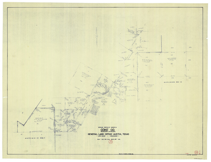
Coke County Working Sketch 25
Print $20.00
- Digital $50.00
Coke County Working Sketch 25
1961
Size 31.4 x 40.7 inches
Map/Doc 68062
[Galveston, Harrisburg & San Antonio Railway]
![64404, [Galveston, Harrisburg & San Antonio Railway], General Map Collection](https://historictexasmaps.com/wmedia_w700/maps/64404.tif.jpg)
Print $20.00
- Digital $50.00
[Galveston, Harrisburg & San Antonio Railway]
1892
Size 13.8 x 34.0 inches
Map/Doc 64404
Lee County Working Sketch 7

Print $20.00
- Digital $50.00
Lee County Working Sketch 7
1977
Size 27.0 x 16.8 inches
Map/Doc 70386
Irion County Boundary File 1a

Print $40.00
- Digital $50.00
Irion County Boundary File 1a
Size 33.5 x 9.3 inches
Map/Doc 55325
Fort Bend County Working Sketch 16

Print $20.00
- Digital $50.00
Fort Bend County Working Sketch 16
1953
Size 42.4 x 46.0 inches
Map/Doc 69222
Neel's Creek of North Bosque

Print $2.00
- Digital $50.00
Neel's Creek of North Bosque
1847
Size 8.9 x 7.9 inches
Map/Doc 69755
Kinney County Rolled Sketch 11

Print $20.00
- Digital $50.00
Kinney County Rolled Sketch 11
1944
Size 39.2 x 32.0 inches
Map/Doc 6540
Haskell County Rolled Sketch 15

Print $20.00
- Digital $50.00
Haskell County Rolled Sketch 15
1991
Size 12.7 x 18.4 inches
Map/Doc 6173
You may also like
Flight Mission No. DQO-8K, Frame 7, Galveston County

Print $20.00
- Digital $50.00
Flight Mission No. DQO-8K, Frame 7, Galveston County
1952
Size 18.7 x 22.4 inches
Map/Doc 85130
Land grants from the state of Tamaulipas in the trans-Nueces

Land grants from the state of Tamaulipas in the trans-Nueces
2009
Size 11.0 x 8.5 inches
Map/Doc 94040
Fannin County Rolled Sketch 18B

Print $20.00
- Digital $50.00
Fannin County Rolled Sketch 18B
Size 12.7 x 16.1 inches
Map/Doc 5869
[Sketch showing surveys 9, 10, 15, 65 and 96]
![91759, [Sketch showing surveys 9, 10, 15, 65 and 96], Twichell Survey Records](https://historictexasmaps.com/wmedia_w700/maps/91759-1.tif.jpg)
Print $20.00
- Digital $50.00
[Sketch showing surveys 9, 10, 15, 65 and 96]
1919
Size 17.9 x 17.1 inches
Map/Doc 91759
Colorado County Rolled Sketch 3

Print $20.00
- Digital $50.00
Colorado County Rolled Sketch 3
1943
Size 42.4 x 38.7 inches
Map/Doc 8641
[Blocks C & C2]
![90747, [Blocks C & C2], Twichell Survey Records](https://historictexasmaps.com/wmedia_w700/maps/90747-1.tif.jpg)
Print $20.00
- Digital $50.00
[Blocks C & C2]
1906
Size 24.7 x 8.9 inches
Map/Doc 90747
Live Oak County Sketch File 13

Print $17.00
- Digital $50.00
Live Oak County Sketch File 13
1880
Size 10.2 x 13.7 inches
Map/Doc 30270
Concho County Rolled Sketch 8

Print $20.00
- Digital $50.00
Concho County Rolled Sketch 8
1956
Size 24.0 x 15.9 inches
Map/Doc 5546
Flight Mission No. CUG-3P, Frame 169, Kleberg County

Print $20.00
- Digital $50.00
Flight Mission No. CUG-3P, Frame 169, Kleberg County
1956
Size 18.5 x 22.2 inches
Map/Doc 86289
Coast Chart No. 212 - From Latitude 26° 33' to the Rio Grande, Texas

Print $20.00
- Digital $50.00
Coast Chart No. 212 - From Latitude 26° 33' to the Rio Grande, Texas
1886
Size 30.5 x 24.1 inches
Map/Doc 73504
Webb County Working Sketch 5

Print $20.00
- Digital $50.00
Webb County Working Sketch 5
1909
Size 20.1 x 15.4 inches
Map/Doc 72370
Dimmit County Working Sketch 47

Print $40.00
- Digital $50.00
Dimmit County Working Sketch 47
1980
Size 71.3 x 43.8 inches
Map/Doc 68708