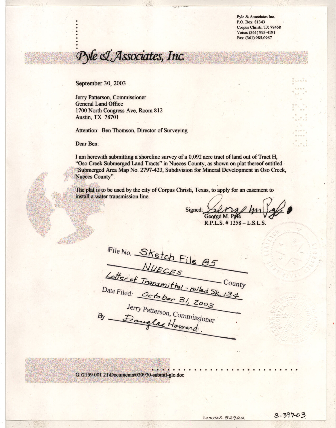
Nueces County Sketch File 85
[Letter of transmittal]
-
Map/Doc
82922
-
Collection
General Map Collection
-
Object Dates
10/31/2003 (File Date)
9/30/2003 (Correspondence Date)
-
People and Organizations
George M. Pyle (Surveyor/Engineer)
-
Counties
Nueces
-
Subjects
Surveying Sketch File
-
Height x Width
11.0 x 8.5 inches
27.9 x 21.6 cm
-
Medium
paper, print
-
Comments
See Nueces County Rolled Sketch 134 (81903) for sketch.
-
Features
Oso Creek
Related maps
Nueces County Rolled Sketch 134

Print $20.00
- Digital $50.00
Nueces County Rolled Sketch 134
2003
Size 24.9 x 36.6 inches
Map/Doc 81903
Part of: General Map Collection
[Index of Texas Prison Farms]
![62977, [Index of Texas Prison Farms], General Map Collection](https://historictexasmaps.com/wmedia_w700/maps/62977.tif.jpg)
Print $20.00
- Digital $50.00
[Index of Texas Prison Farms]
Size 31.1 x 23.1 inches
Map/Doc 62977
McMullen County Working Sketch 33

Print $20.00
- Digital $50.00
McMullen County Working Sketch 33
1959
Size 37.3 x 27.0 inches
Map/Doc 70734
Map of Denton County

Print $20.00
- Digital $50.00
Map of Denton County
1896
Size 25.6 x 22.0 inches
Map/Doc 11311
A new map for travellers through the United States of America showing the railroads, canals & stageroads with the distances

Print $20.00
- Digital $50.00
A new map for travellers through the United States of America showing the railroads, canals & stageroads with the distances
1846
Size 22.4 x 27.9 inches
Map/Doc 95921
Refugio County Rolled Sketch 10

Print $42.00
- Digital $50.00
Refugio County Rolled Sketch 10
Size 49.9 x 39.1 inches
Map/Doc 9861
Mills County Working Sketch 18

Print $20.00
- Digital $50.00
Mills County Working Sketch 18
1963
Size 23.2 x 37.0 inches
Map/Doc 71048
Upton County Working Sketch 48

Print $20.00
- Digital $50.00
Upton County Working Sketch 48
1975
Size 29.3 x 24.3 inches
Map/Doc 69544
Webb County Sketch File VOLP

Print $40.00
- Digital $50.00
Webb County Sketch File VOLP
1937
Size 18.9 x 33.8 inches
Map/Doc 12607
Upton County Working Sketch 25

Print $20.00
- Digital $50.00
Upton County Working Sketch 25
1953
Size 38.2 x 31.2 inches
Map/Doc 69521
Terrell County Working Sketch 76

Print $20.00
- Digital $50.00
Terrell County Working Sketch 76
1982
Size 31.8 x 20.1 inches
Map/Doc 69597
Trinity River, Oliver Crossing Sheet/Chambers Creek

Print $6.00
- Digital $50.00
Trinity River, Oliver Crossing Sheet/Chambers Creek
1931
Size 30.1 x 28.2 inches
Map/Doc 65231
Fractional Township No. 8 South Range No. 5 East of the Indian Meridian, Indian Territory

Print $20.00
- Digital $50.00
Fractional Township No. 8 South Range No. 5 East of the Indian Meridian, Indian Territory
1898
Size 19.2 x 24.4 inches
Map/Doc 75209
You may also like
Wheeler County Sketch File 8

Print $6.00
- Digital $50.00
Wheeler County Sketch File 8
1935
Size 11.4 x 8.8 inches
Map/Doc 40005
English Field Notes of the Spanish Archives - Books JMH, MCMCHB, TGI

English Field Notes of the Spanish Archives - Books JMH, MCMCHB, TGI
1835
Map/Doc 96547
Callahan County Boundary File 1a

Print $4.00
- Digital $50.00
Callahan County Boundary File 1a
Size 13.3 x 8.7 inches
Map/Doc 51085
Hays County Sketch File 17

Print $8.00
- Digital $50.00
Hays County Sketch File 17
1877
Size 12.9 x 8.4 inches
Map/Doc 26231
United States, 1956 Revised Edition

Print $20.00
- Digital $50.00
United States, 1956 Revised Edition
1946
Size 47.9 x 35.9 inches
Map/Doc 78630
Marion County Rolled Sketch JRC

Print $20.00
- Digital $50.00
Marion County Rolled Sketch JRC
1953
Size 19.4 x 20.5 inches
Map/Doc 6662
Reconnaissance of the Coast of Texas Between Matagorda and Corpus Christi Bays

Print $20.00
Reconnaissance of the Coast of Texas Between Matagorda and Corpus Christi Bays
1858
Size 25.8 x 21.1 inches
Map/Doc 76248
West Half Section 4, Block C-33, Gaines County, Texas

Print $20.00
- Digital $50.00
West Half Section 4, Block C-33, Gaines County, Texas
1953
Size 12.9 x 23.7 inches
Map/Doc 92667
Nueces County NRC Article 33.136 Sketch 14

Print $54.00
- Digital $50.00
Nueces County NRC Article 33.136 Sketch 14
2008
Size 35.0 x 23.0 inches
Map/Doc 95162
Flight Mission No. BRA-7M, Frame 151, Jefferson County

Print $20.00
- Digital $50.00
Flight Mission No. BRA-7M, Frame 151, Jefferson County
1953
Size 18.7 x 22.6 inches
Map/Doc 85545
Flight Mission No. DQO-3K, Frame 41, Galveston County

Print $20.00
- Digital $50.00
Flight Mission No. DQO-3K, Frame 41, Galveston County
1952
Size 18.7 x 22.5 inches
Map/Doc 85082
Map of north end of Brazos Island

Print $20.00
- Digital $50.00
Map of north end of Brazos Island
Size 27.6 x 18.2 inches
Map/Doc 72908