Webb County Sketch File VOLP
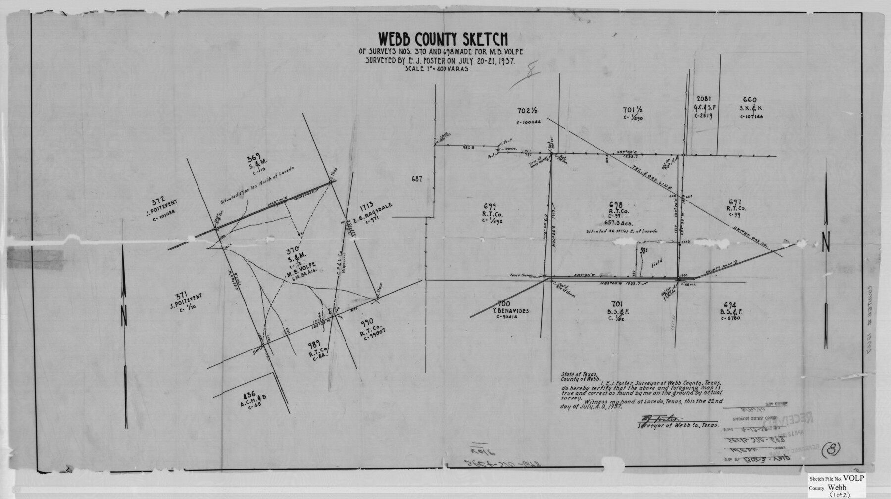
[Sketch of survey nos. 370 - north of Laredo - and no. 698 - east of Laredo - made for M.B. Volpe]
-
Map/Doc
12607
-
Collection
General Map Collection
-
Object Dates
7/22/1937 (Creation Date)
4/19/1939 (File Date)
7/20-21/1937 (Survey Date)
-
People and Organizations
E.J. Foster (Surveyor/Engineer)
-
Counties
Webb
-
Subjects
Surveying Sketch File
-
Height x Width
18.9 x 33.8 inches
48.0 x 85.9 cm
-
Medium
multi-page, multi-format
-
Scale
1" = 400 varas
Part of: General Map Collection
Edwards County Rolled Sketch 26

Print $20.00
- Digital $50.00
Edwards County Rolled Sketch 26
1958
Size 25.0 x 17.5 inches
Map/Doc 5812
Trinity County Sketch File 28

Print $22.00
- Digital $50.00
Trinity County Sketch File 28
Size 7.0 x 19.7 inches
Map/Doc 38564
Jefferson County Rolled Sketch 7

Print $20.00
- Digital $50.00
Jefferson County Rolled Sketch 7
1928
Size 30.8 x 34.2 inches
Map/Doc 9272
Hutchinson County Rolled Sketch 31

Print $75.00
- Digital $50.00
Hutchinson County Rolled Sketch 31
1908
Size 19.3 x 15.8 inches
Map/Doc 6292
Austin Street Map & Guide

Digital $50.00
Austin Street Map & Guide
Size 35.4 x 23.1 inches
Map/Doc 94435
Liberty County Sketch File 63

Print $138.00
- Digital $50.00
Liberty County Sketch File 63
1983
Size 11.1 x 8.8 inches
Map/Doc 30087
Hardin County Working Sketch 12

Print $20.00
- Digital $50.00
Hardin County Working Sketch 12
1934
Size 16.8 x 11.9 inches
Map/Doc 63410
Hardin County Sketch File 45

Print $2.00
- Digital $50.00
Hardin County Sketch File 45
Size 8.3 x 6.2 inches
Map/Doc 25195
Flight Mission No. BRA-16M, Frame 123, Jefferson County

Print $20.00
- Digital $50.00
Flight Mission No. BRA-16M, Frame 123, Jefferson County
1953
Size 18.6 x 22.5 inches
Map/Doc 85733
Flight Mission No. BRA-7M, Frame 141, Jefferson County

Print $20.00
- Digital $50.00
Flight Mission No. BRA-7M, Frame 141, Jefferson County
1953
Size 18.6 x 22.4 inches
Map/Doc 85535
Kleberg County Rolled Sketch 10-8

Print $20.00
- Digital $50.00
Kleberg County Rolled Sketch 10-8
1951
Size 36.6 x 33.7 inches
Map/Doc 9370
Hudspeth County Working Sketch 3

Print $20.00
- Digital $50.00
Hudspeth County Working Sketch 3
1913
Size 20.4 x 17.2 inches
Map/Doc 66284
You may also like
King County Working Sketch 3

Print $20.00
- Digital $50.00
King County Working Sketch 3
1934
Size 10.4 x 20.1 inches
Map/Doc 70167
Starr County Sketch File 48

Print $20.00
- Digital $50.00
Starr County Sketch File 48
1950
Size 22.3 x 10.8 inches
Map/Doc 12345
Flight Mission No. DQO-8K, Frame 47, Galveston County

Print $20.00
- Digital $50.00
Flight Mission No. DQO-8K, Frame 47, Galveston County
1952
Size 18.7 x 22.2 inches
Map/Doc 85154
Wise County Working Sketch 19

Print $20.00
- Digital $50.00
Wise County Working Sketch 19
1978
Size 28.6 x 32.5 inches
Map/Doc 72633
Flight Mission No. DQN-2K, Frame 121, Calhoun County

Print $20.00
- Digital $50.00
Flight Mission No. DQN-2K, Frame 121, Calhoun County
1953
Size 16.3 x 16.3 inches
Map/Doc 84297
Map of Africa engraved to illustrate Mitchell's new intermediate geography (Inset 1: Map of Egypt / Inset 2: Liberia and Sierra Leone)

Print $20.00
- Digital $50.00
Map of Africa engraved to illustrate Mitchell's new intermediate geography (Inset 1: Map of Egypt / Inset 2: Liberia and Sierra Leone)
1885
Size 9.0 x 12.2 inches
Map/Doc 93530
Van Zandt County

Print $20.00
- Digital $50.00
Van Zandt County
1896
Size 26.1 x 22.4 inches
Map/Doc 4114
Flight Mission No. CGI-3N, Frame 187, Cameron County

Print $20.00
- Digital $50.00
Flight Mission No. CGI-3N, Frame 187, Cameron County
1954
Size 18.5 x 22.2 inches
Map/Doc 84651
Atascosa County Sketch File 36

Print $20.00
- Digital $50.00
Atascosa County Sketch File 36
1947
Size 16.0 x 22.3 inches
Map/Doc 10867
Fisher County Working Sketch 4

Print $20.00
- Digital $50.00
Fisher County Working Sketch 4
1926
Size 24.4 x 17.2 inches
Map/Doc 69138
Washington County

Print $20.00
- Digital $50.00
Washington County
1863
Size 15.9 x 27.2 inches
Map/Doc 4127
Kleberg County Rolled Sketch 11

Print $20.00
- Digital $50.00
Kleberg County Rolled Sketch 11
1915
Size 21.0 x 26.5 inches
Map/Doc 6552