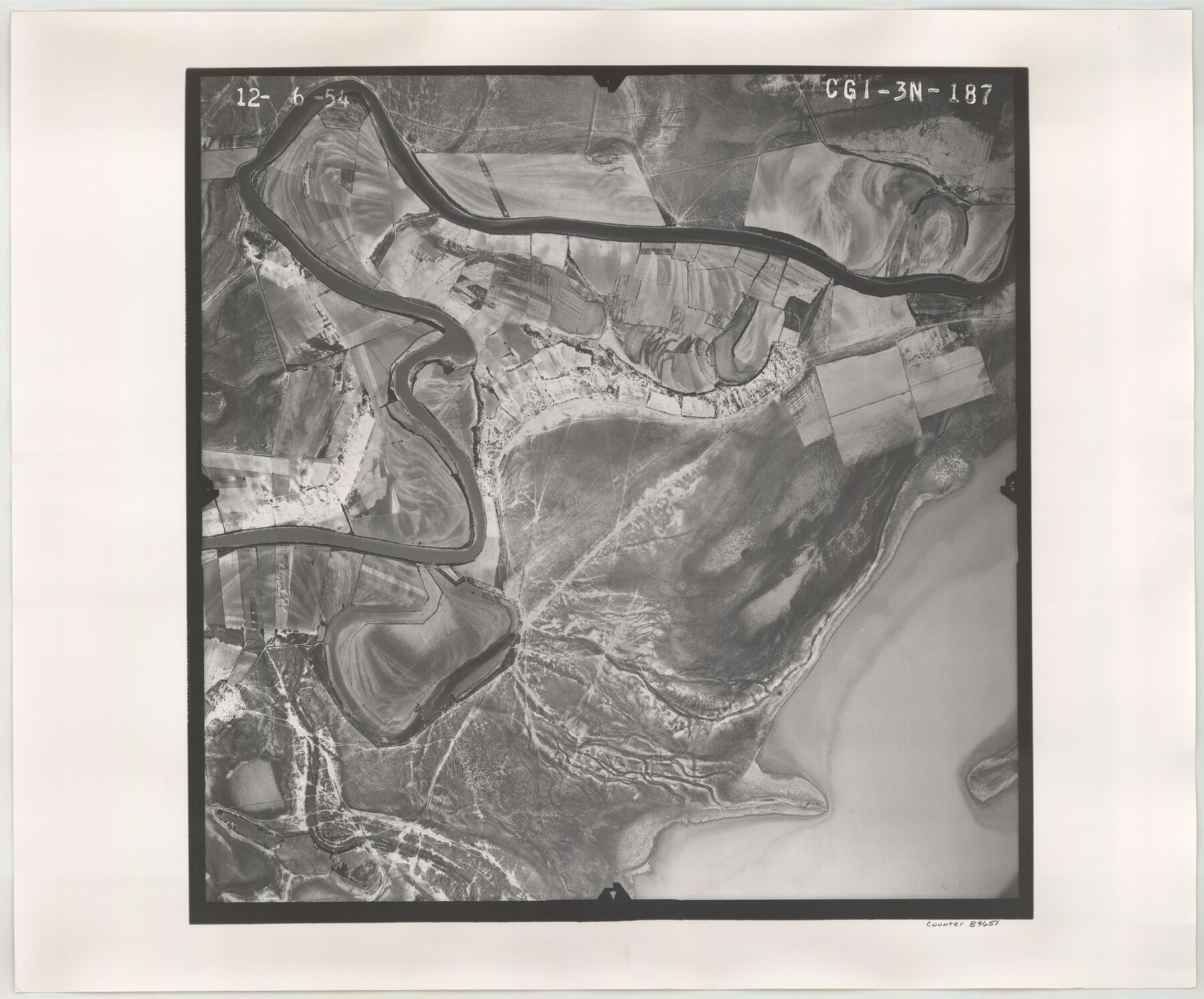
Flight Mission No. CGI-3N, Frame 187, Cameron County
CGI-3N-187
-
Map/Doc
84651
-
Collection
General Map Collection
-
Object Dates
1954/12/6 (Creation Date)
-
People and Organizations
U. S. Department of Agriculture (Publisher)
-
Counties
Cameron
-
Subjects
Aerial Photograph
-
Height x Width
18.5 x 22.2 inches
47.0 x 56.4 cm
-
Comments
Flown by Puckett Aerial Surveys, Inc. of Jackson, Mississippi.
Part of: General Map Collection
Flight Mission No. BRA-3M, Frame 197, Jefferson County

Print $20.00
- Digital $50.00
Flight Mission No. BRA-3M, Frame 197, Jefferson County
1953
Size 18.6 x 22.4 inches
Map/Doc 85412
Liberty County Working Sketch 16

Print $20.00
- Digital $50.00
Liberty County Working Sketch 16
1936
Size 24.1 x 34.7 inches
Map/Doc 70475
[Surveys along the Texas coast across from Mustang Island]
![346, [Surveys along the Texas coast across from Mustang Island], General Map Collection](https://historictexasmaps.com/wmedia_w700/maps/346.tif.jpg)
Print $2.00
- Digital $50.00
[Surveys along the Texas coast across from Mustang Island]
1841
Size 11.3 x 7.3 inches
Map/Doc 346
Flight Mission No. DQN-1K, Frame 30, Calhoun County

Print $20.00
- Digital $50.00
Flight Mission No. DQN-1K, Frame 30, Calhoun County
1953
Size 18.6 x 22.2 inches
Map/Doc 84135
Pecos County Sketch File 23

Print $20.00
- Digital $50.00
Pecos County Sketch File 23
1886
Size 18.0 x 18.0 inches
Map/Doc 12162
Castro County Sketch File 4b

Print $4.00
- Digital $50.00
Castro County Sketch File 4b
Size 13.5 x 8.9 inches
Map/Doc 17467
Jeff Davis County Working Sketch 45

Print $20.00
- Digital $50.00
Jeff Davis County Working Sketch 45
1990
Size 27.8 x 38.1 inches
Map/Doc 66540
Flight Mission No. DIX-3P, Frame 169, Aransas County

Print $20.00
- Digital $50.00
Flight Mission No. DIX-3P, Frame 169, Aransas County
1956
Size 17.8 x 18.3 inches
Map/Doc 83775
Map of Starr County

Print $40.00
- Digital $50.00
Map of Starr County
1900
Size 51.6 x 25.8 inches
Map/Doc 4046
Flight Mission No. CRC-4R, Frame 97, Chambers County

Print $20.00
- Digital $50.00
Flight Mission No. CRC-4R, Frame 97, Chambers County
1956
Size 18.6 x 22.2 inches
Map/Doc 84894
Tarrant County Working Sketch 18

Print $20.00
- Digital $50.00
Tarrant County Working Sketch 18
1996
Size 20.4 x 18.5 inches
Map/Doc 62435
You may also like
Flight Mission No. DQO-14T, Frame 65, Galveston County

Print $20.00
- Digital $50.00
Flight Mission No. DQO-14T, Frame 65, Galveston County
1958
Size 17.6 x 17.4 inches
Map/Doc 85216
Stonewall County Working Sketch 17

Print $20.00
- Digital $50.00
Stonewall County Working Sketch 17
1954
Size 31.5 x 24.7 inches
Map/Doc 62324
Fisher County Working Sketch 17

Print $20.00
- Digital $50.00
Fisher County Working Sketch 17
1972
Size 32.2 x 24.6 inches
Map/Doc 69151
Hardin County Sketch File 54

Print $20.00
- Digital $50.00
Hardin County Sketch File 54
1924
Size 16.6 x 17.9 inches
Map/Doc 11635
Menard County Boundary File 2b

Print $6.00
- Digital $50.00
Menard County Boundary File 2b
Size 13.3 x 8.2 inches
Map/Doc 57069
City of Austin, Texas - Use District Map

Print $20.00
- Digital $50.00
City of Austin, Texas - Use District Map
1943
Size 38.9 x 25.7 inches
Map/Doc 95705
Pecos County Rolled Sketch 65

Print $20.00
- Digital $50.00
Pecos County Rolled Sketch 65
1928
Size 37.9 x 33.8 inches
Map/Doc 9699
Jefferson County Boundary File 1

Print $10.00
- Digital $50.00
Jefferson County Boundary File 1
Size 9.8 x 6.7 inches
Map/Doc 55514
McCulloch County Sketch File 12

Print $6.00
- Digital $50.00
McCulloch County Sketch File 12
1989
Size 14.2 x 8.6 inches
Map/Doc 31198
Marion County Sketch File 9

Print $4.00
- Digital $50.00
Marion County Sketch File 9
Size 9.4 x 7.8 inches
Map/Doc 30577
[Sections 77-114, Block 47 and part of G. & M. Blocks 2 and 3]
![91827, [Sections 77-114, Block 47 and part of G. & M. Blocks 2 and 3], Twichell Survey Records](https://historictexasmaps.com/wmedia_w700/maps/91827-1.tif.jpg)
Print $20.00
- Digital $50.00
[Sections 77-114, Block 47 and part of G. & M. Blocks 2 and 3]
Size 38.1 x 19.8 inches
Map/Doc 91827
Presidio County Working Sketch 18

Print $20.00
- Digital $50.00
Presidio County Working Sketch 18
1943
Size 26.0 x 25.4 inches
Map/Doc 71694