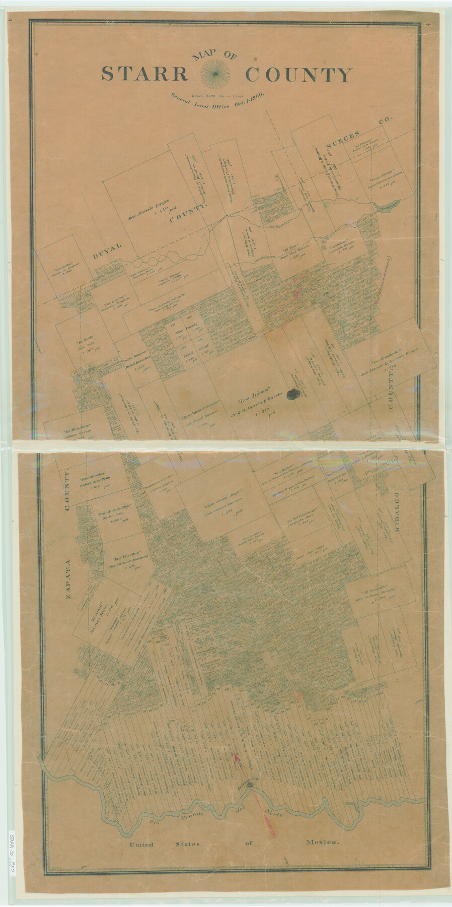
Map of Starr County
-
Map/Doc
4046
-
Collection
General Map Collection
-
Object Dates
1900/10/1 (Creation Date)
-
People and Organizations
Texas General Land Office (Publisher)
Sidney J. Rowe (Draftsman)
Sidney J. Rowe (Compiler)
-
Counties
Starr
-
Subjects
County
-
Height x Width
51.6 x 25.8 inches
131.1 x 65.5 cm
-
Comments
Help Save Texas History - Adopt Me!
-
Features
San Pedro Lake
Falfurrias
Palo Blanco Creek
San Antonio Creek
Rio Grande City
Rio Grande del Norte
Part of: General Map Collection
Brewster County Sketch File N-10

Print $14.00
- Digital $50.00
Brewster County Sketch File N-10
1922
Size 11.2 x 8.7 inches
Map/Doc 15616
Corpus Christi Pass, Texas

Print $20.00
- Digital $50.00
Corpus Christi Pass, Texas
1871
Size 26.1 x 18.2 inches
Map/Doc 72980
Milam County Rolled Sketch 5

Print $20.00
- Digital $50.00
Milam County Rolled Sketch 5
Size 27.9 x 39.8 inches
Map/Doc 6777
Gaines County Sketch File 9

Print $20.00
- Digital $50.00
Gaines County Sketch File 9
Size 34.1 x 17.1 inches
Map/Doc 11524
Motley County Sketch File B4 (N)

Print $20.00
- Digital $50.00
Motley County Sketch File B4 (N)
1900
Size 23.5 x 25.8 inches
Map/Doc 42151
Goliad County Working Sketch 17

Print $20.00
- Digital $50.00
Goliad County Working Sketch 17
1949
Size 21.8 x 22.2 inches
Map/Doc 63207
Potter County Working Sketch 14

Print $20.00
- Digital $50.00
Potter County Working Sketch 14
1982
Size 33.7 x 32.6 inches
Map/Doc 71674
[Right of Way Map, Belton Branch of the M.K.&T. RR.]
![64225, [Right of Way Map, Belton Branch of the M.K.&T. RR.], General Map Collection](https://historictexasmaps.com/wmedia_w700/maps/64225.tif.jpg)
Print $20.00
- Digital $50.00
[Right of Way Map, Belton Branch of the M.K.&T. RR.]
1896
Size 7.2 x 21.6 inches
Map/Doc 64225
Plan of the City of Galveston, Texas

Print $20.00
- Digital $50.00
Plan of the City of Galveston, Texas
1845
Size 19.3 x 41.8 inches
Map/Doc 4665
Sketch of coast of Texas, Laguna Madre from Pt. of Rocks to Corpus Christi [and accompanying letter]
![72963, Sketch of coast of Texas, Laguna Madre from Pt. of Rocks to Corpus Christi [and accompanying letter], General Map Collection](https://historictexasmaps.com/wmedia_w700/maps/72963.tif.jpg)
Print $2.00
- Digital $50.00
Sketch of coast of Texas, Laguna Madre from Pt. of Rocks to Corpus Christi [and accompanying letter]
1882
Size 11.2 x 8.8 inches
Map/Doc 72963
Rusk County Sketch File 30

Print $10.00
Rusk County Sketch File 30
1949
Size 11.3 x 8.9 inches
Map/Doc 35558
Donley County Boundary File 4

Print $10.00
- Digital $50.00
Donley County Boundary File 4
Size 5.7 x 8.4 inches
Map/Doc 52630
You may also like

Trinity River, Kaufman Sheet/Kings Creek

Print $6.00
- Digital $50.00
Trinity River, Kaufman Sheet/Kings Creek
1930
Size 32.6 x 27.0 inches
Map/Doc 65228
[Map of Polk County]
![4614, [Map of Polk County], General Map Collection](https://historictexasmaps.com/wmedia_w700/maps/4614-1.tif.jpg)
Print $20.00
- Digital $50.00
[Map of Polk County]
Size 21.7 x 25.8 inches
Map/Doc 4614
Duval County Sketch File 35a

Print $26.00
- Digital $50.00
Duval County Sketch File 35a
Size 11.3 x 8.9 inches
Map/Doc 21371
Plat of Fee Land Adjoining the Town of Lovington, New Mexico

Print $20.00
- Digital $50.00
Plat of Fee Land Adjoining the Town of Lovington, New Mexico
Size 24.2 x 18.4 inches
Map/Doc 92422
Duval County Sketch File 36a

Print $10.00
- Digital $50.00
Duval County Sketch File 36a
1935
Size 11.4 x 8.8 inches
Map/Doc 21380
General Highway Map, Starr County, Texas

Print $20.00
General Highway Map, Starr County, Texas
1961
Size 24.9 x 18.1 inches
Map/Doc 79658
Lipscomb County Working Sketch 1

Print $20.00
- Digital $50.00
Lipscomb County Working Sketch 1
1964
Size 30.7 x 34.1 inches
Map/Doc 70577
[E. L. & R. R. RR. Co. Block D8 and vicinity]
![91863, [E. L. & R. R. RR. Co. Block D8 and vicinity], Twichell Survey Records](https://historictexasmaps.com/wmedia_w700/maps/91863-1.tif.jpg)
Print $20.00
- Digital $50.00
[E. L. & R. R. RR. Co. Block D8 and vicinity]
1891
Size 18.5 x 21.0 inches
Map/Doc 91863
Gray County Sketch File 13

Print $20.00
- Digital $50.00
Gray County Sketch File 13
1946
Size 16.7 x 15.9 inches
Map/Doc 11578
Presidio County Rolled Sketch 4

Print $2.00
- Digital $50.00
Presidio County Rolled Sketch 4
Size 10.1 x 6.3 inches
Map/Doc 75984
Crockett County Working Sketch 49

Print $20.00
- Digital $50.00
Crockett County Working Sketch 49
1938
Size 46.7 x 43.9 inches
Map/Doc 68382