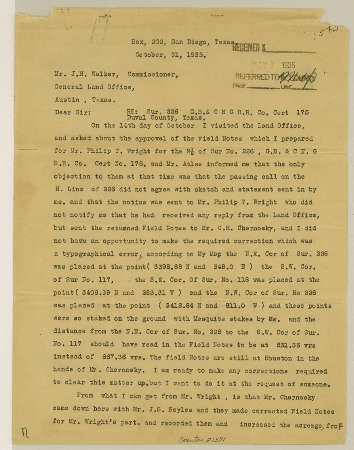
Duval County Sketch File 35a
Extreme N. Central part
-
Map/Doc
21371
-
Collection
General Map Collection
-
Object Dates
1935/4/24 (File Date)
1935/4/5
-
People and Organizations
J.S. Boyles (Surveyor/Engineer)
J.L. Dellis (Surveyor/Engineer)
-
Counties
Duval
-
Subjects
Surveying Sketch File
-
Height x Width
11.3 x 8.9 inches
28.7 x 22.6 cm
-
Medium
multi-page, multi-format
-
Scale
1" = 200 varas
Part of: General Map Collection
Presidio County Sketch File 116A

Print $63.00
- Digital $50.00
Presidio County Sketch File 116A
Size 17.0 x 11.0 inches
Map/Doc 34885
Hutchinson County Working Sketch 13

Print $20.00
- Digital $50.00
Hutchinson County Working Sketch 13
1926
Size 22.6 x 31.5 inches
Map/Doc 66371
Flight Mission No. CRC-3R, Frame 206, Chambers County

Print $20.00
- Digital $50.00
Flight Mission No. CRC-3R, Frame 206, Chambers County
1956
Size 18.5 x 22.2 inches
Map/Doc 84861
Jeff Davis County Texas

Print $20.00
- Digital $50.00
Jeff Davis County Texas
Size 15.9 x 21.3 inches
Map/Doc 4573
Montague County Sketch File 9

Print $18.00
- Digital $50.00
Montague County Sketch File 9
1872
Size 12.6 x 11.7 inches
Map/Doc 31724
Presidio County Sketch File 14

Print $52.00
- Digital $50.00
Presidio County Sketch File 14
1883
Size 15.3 x 18.8 inches
Map/Doc 11707
Map of Liberty County

Print $40.00
- Digital $50.00
Map of Liberty County
1903
Size 54.9 x 53.6 inches
Map/Doc 16878
Sutton County Rolled Sketch H

Print $40.00
- Digital $50.00
Sutton County Rolled Sketch H
Size 24.9 x 50.0 inches
Map/Doc 9973
Flight Mission No. DCL-7C, Frame 70, Kenedy County

Print $20.00
- Digital $50.00
Flight Mission No. DCL-7C, Frame 70, Kenedy County
1943
Size 15.4 x 15.3 inches
Map/Doc 86056
Brewster County Sketch File N-3d

Print $13.00
- Digital $50.00
Brewster County Sketch File N-3d
1889
Size 14.2 x 8.7 inches
Map/Doc 15596
Bailey County

Print $40.00
- Digital $50.00
Bailey County
1956
Size 49.4 x 31.4 inches
Map/Doc 95423
Nueces County Sketch File 8

Print $22.00
- Digital $50.00
Nueces County Sketch File 8
1849
Size 8.2 x 12.4 inches
Map/Doc 32512
You may also like
Pecos County Sketch File 85

Print $19.00
- Digital $50.00
Pecos County Sketch File 85
1948
Size 14.6 x 9.2 inches
Map/Doc 33955
Map of Bandera County, Texas

Print $20.00
- Digital $50.00
Map of Bandera County, Texas
1879
Size 19.6 x 32.6 inches
Map/Doc 691
Goliad County Sketch File 39

Print $14.00
- Digital $50.00
Goliad County Sketch File 39
1941
Size 14.3 x 8.8 inches
Map/Doc 24340
Armstrong County Working Sketch 9

Print $20.00
- Digital $50.00
Armstrong County Working Sketch 9
1993
Size 40.9 x 33.6 inches
Map/Doc 67240
Hunt County Sketch File 10

Print $4.00
- Digital $50.00
Hunt County Sketch File 10
1859
Size 12.4 x 8.0 inches
Map/Doc 27100
Nueces County Rolled Sketch 4

Print $20.00
- Digital $50.00
Nueces County Rolled Sketch 4
1910
Size 39.8 x 38.5 inches
Map/Doc 9583
Upton County Rolled Sketch 7

Print $62.00
- Digital $50.00
Upton County Rolled Sketch 7
1911
Size 10.5 x 15.0 inches
Map/Doc 49398
Jeff Davis County Working Sketch Graphic Index - west part

Print $20.00
- Digital $50.00
Jeff Davis County Working Sketch Graphic Index - west part
1977
Size 34.0 x 45.3 inches
Map/Doc 76594
Flight Mission No. CRC-3R, Frame 104, Chambers County

Print $20.00
- Digital $50.00
Flight Mission No. CRC-3R, Frame 104, Chambers County
1956
Size 18.6 x 22.3 inches
Map/Doc 84842
[F. W. & D. C. Ry. Co. Alignment and Right of Way Map, Clay County]
![64735, [F. W. & D. C. Ry. Co. Alignment and Right of Way Map, Clay County], General Map Collection](https://historictexasmaps.com/wmedia_w700/maps/64735-GC.tif.jpg)
Print $20.00
- Digital $50.00
[F. W. & D. C. Ry. Co. Alignment and Right of Way Map, Clay County]
1927
Size 18.6 x 11.8 inches
Map/Doc 64735
Flight Mission No. CGI-3N, Frame 100, Cameron County

Print $20.00
- Digital $50.00
Flight Mission No. CGI-3N, Frame 100, Cameron County
1954
Size 18.6 x 22.3 inches
Map/Doc 84580
Atascosa County Boundary File 7

Print $20.00
- Digital $50.00
Atascosa County Boundary File 7
Size 8.2 x 10.1 inches
Map/Doc 50213