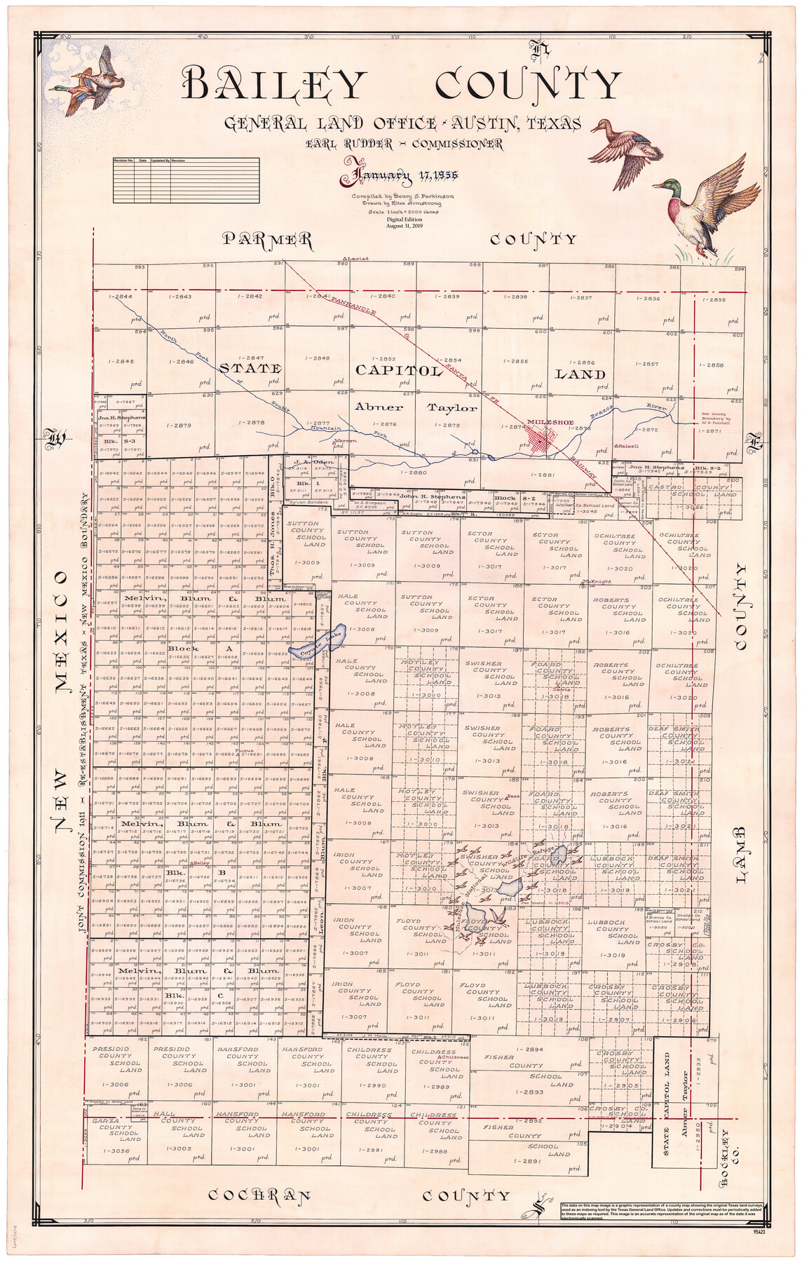
Bailey County
General Land Office Official County Map
-
Map/Doc
95423
-
Collection
General Map Collection
-
Object Dates
2019/8/31 (Revision Date)
1956/1/17 (Creation Date)
-
People and Organizations
Cheyenne Betancourt (Draftsman)
Eltea Armstrong (Draftsman)
Henry S. Parkinson (Compiler)
Earl Rudder (GLO Commissioner)
-
Counties
Bailey
-
Subjects
County OCM
-
Height x Width
49.4 x 31.4 inches
125.5 x 79.8 cm
-
Medium
digital image
-
Scale
1" = 2000 varas
Part of: General Map Collection
Stephens County Texas

Print $20.00
- Digital $50.00
Stephens County Texas
Size 20.8 x 18.6 inches
Map/Doc 4627
Harris County Working Sketch 83

Print $20.00
- Digital $50.00
Harris County Working Sketch 83
1970
Size 26.0 x 30.1 inches
Map/Doc 65975
Kent County Boundary File 3

Print $8.00
- Digital $50.00
Kent County Boundary File 3
Size 11.2 x 8.6 inches
Map/Doc 55824
Montgomery County Working Sketch 76

Print $20.00
- Digital $50.00
Montgomery County Working Sketch 76
Size 16.5 x 18.3 inches
Map/Doc 78191
Hardeman County Working Sketch 6

Print $20.00
- Digital $50.00
Hardeman County Working Sketch 6
1944
Size 25.9 x 17.8 inches
Map/Doc 63387
Calhoun County NRC Article 33.136 Sketch 1

Print $42.00
- Digital $50.00
Calhoun County NRC Article 33.136 Sketch 1
2000
Size 16.8 x 21.7 inches
Map/Doc 61556
Reagan County Boundary File 1a

Print $50.00
- Digital $50.00
Reagan County Boundary File 1a
Size 14.4 x 8.7 inches
Map/Doc 58154
Kerr County Sketch File 21

Print $10.00
- Digital $50.00
Kerr County Sketch File 21
1954
Size 11.1 x 8.7 inches
Map/Doc 28892
Bell County Working Sketch 14

Print $20.00
- Digital $50.00
Bell County Working Sketch 14
1966
Size 38.7 x 30.8 inches
Map/Doc 67354

Flight Mission No. BRE-1P, Frame 116, Nueces County

Print $20.00
- Digital $50.00
Flight Mission No. BRE-1P, Frame 116, Nueces County
1956
Size 18.6 x 22.5 inches
Map/Doc 86682
Galveston County Rolled Sketch 24

Print $20.00
- Digital $50.00
Galveston County Rolled Sketch 24
1973
Size 28.1 x 25.6 inches
Map/Doc 5958
You may also like
Boundary Between the United States & Mexico Agreed upon by the Joint Commission under the Treaty of Guadalupe Hidalgo

Print $20.00
- Digital $50.00
Boundary Between the United States & Mexico Agreed upon by the Joint Commission under the Treaty of Guadalupe Hidalgo
1853
Size 18.3 x 26.5 inches
Map/Doc 72886
A New Map of the United States of America

Print $20.00
A New Map of the United States of America
1856
Size 17.8 x 28.0 inches
Map/Doc 79320
Briscoe County

Print $20.00
- Digital $50.00
Briscoe County
1930
Size 42.0 x 35.8 inches
Map/Doc 73090
Val Verde County Sketch File 18

Print $8.00
- Digital $50.00
Val Verde County Sketch File 18
1883
Size 13.1 x 8.4 inches
Map/Doc 39225
Map showing the line of march of the Centre Division, Army of Mexico, under the command of Brigr. Genl. John E. Wool, from San Antonio de Bexar, Texas to Saltillo, Mexico

Print $20.00
- Digital $50.00
Map showing the line of march of the Centre Division, Army of Mexico, under the command of Brigr. Genl. John E. Wool, from San Antonio de Bexar, Texas to Saltillo, Mexico
1846
Size 24.5 x 19.5 inches
Map/Doc 94074
Wilbarger County Working Sketch 2b

Print $20.00
- Digital $50.00
Wilbarger County Working Sketch 2b
1922
Size 19.8 x 20.0 inches
Map/Doc 72540
Kleberg County Rolled Sketch 10-35

Print $20.00
- Digital $50.00
Kleberg County Rolled Sketch 10-35
1952
Size 38.2 x 35.4 inches
Map/Doc 9366
Trinity County Sketch File 8

Print $6.00
- Digital $50.00
Trinity County Sketch File 8
1859
Size 12.8 x 7.9 inches
Map/Doc 38513
Survey for H.A. Wroe

Print $20.00
- Digital $50.00
Survey for H.A. Wroe
Size 19.6 x 10.4 inches
Map/Doc 601
General Highway Map, Roberts County, Texas

Print $20.00
General Highway Map, Roberts County, Texas
1940
Size 18.4 x 25.0 inches
Map/Doc 79229

Map of the United States of America for Goddard's "Where to Emigrate and Why"

Print $20.00
- Digital $50.00
Map of the United States of America for Goddard's "Where to Emigrate and Why"
1869
Size 12.4 x 18.8 inches
Map/Doc 96619