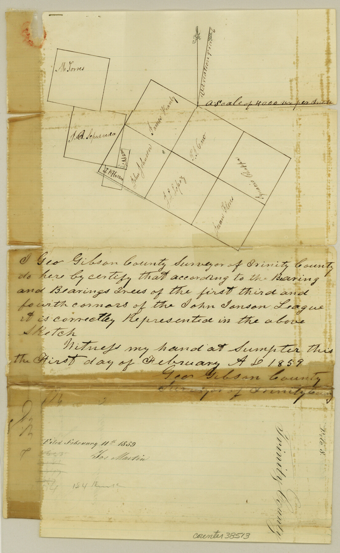
Trinity County Sketch File 8
[Sketch and explanation regarding J. Johnson league southwest from Groveton]
-
Map/Doc
38513
-
Collection
General Map Collection
-
Object Dates
2/1859 (Creation Date)
-
People and Organizations
George Gibson (Surveyor/Engineer)
-
Counties
Trinity
-
Subjects
Surveying Sketch File
-
Height x Width
12.8 x 7.9 inches
32.5 x 20.1 cm
-
Medium
paper, manuscript
Part of: General Map Collection
Kenedy County Rolled Sketch 5

Print $20.00
- Digital $50.00
Kenedy County Rolled Sketch 5
1911
Size 27.9 x 24.4 inches
Map/Doc 6462
S. M. S. Throckmorton Ranch, Throckmorton, Haskell, Baylor Cos.

Print $20.00
- Digital $50.00
S. M. S. Throckmorton Ranch, Throckmorton, Haskell, Baylor Cos.
1955
Size 33.8 x 45.1 inches
Map/Doc 2104
Lee County Sketch File 4

Print $4.00
- Digital $50.00
Lee County Sketch File 4
1859
Size 9.5 x 8.1 inches
Map/Doc 29682
Map of Leon County

Print $40.00
- Digital $50.00
Map of Leon County
1916
Size 49.3 x 42.5 inches
Map/Doc 66901
Copy of Surveyor's Field Book, Morris Browning - In Blocks 7, 5 & 4, I&GNRRCo., Hutchinson and Carson Counties, Texas

Print $2.00
- Digital $50.00
Copy of Surveyor's Field Book, Morris Browning - In Blocks 7, 5 & 4, I&GNRRCo., Hutchinson and Carson Counties, Texas
1888
Size 6.9 x 8.8 inches
Map/Doc 62260
[Peter's Colony surveys in Stephens County]
![75986, [Peter's Colony surveys in Stephens County], General Map Collection](https://historictexasmaps.com/wmedia_w700/maps/75986.tif.jpg)
Print $20.00
- Digital $50.00
[Peter's Colony surveys in Stephens County]
Size 25.3 x 21.1 inches
Map/Doc 75986
Travis County Rolled Sketch 13

Print $20.00
- Digital $50.00
Travis County Rolled Sketch 13
Size 28.0 x 20.4 inches
Map/Doc 8016
Terrell County Sketch File 38

Print $6.00
- Digital $50.00
Terrell County Sketch File 38
1987
Size 11.3 x 8.8 inches
Map/Doc 38001
Henderson County Sketch File 11

Print $2.00
- Digital $50.00
Henderson County Sketch File 11
Size 8.5 x 3.7 inches
Map/Doc 26348
Victoria County Working Sketch 11

Print $20.00
- Digital $50.00
Victoria County Working Sketch 11
2004
Size 34.7 x 36.0 inches
Map/Doc 83591
Roberts County

Print $20.00
- Digital $50.00
Roberts County
1932
Size 41.9 x 38.0 inches
Map/Doc 73275
Fannin County Boundary File 1a

Print $40.00
- Digital $50.00
Fannin County Boundary File 1a
1882
Size 36.5 x 9.5 inches
Map/Doc 53279
You may also like
Calhoun County NRC Article 33.136 Location Key Sheet

Print $20.00
- Digital $50.00
Calhoun County NRC Article 33.136 Location Key Sheet
1973
Size 27.0 x 23.0 inches
Map/Doc 87907
East Part of Jeff Davis Co.

Print $20.00
- Digital $50.00
East Part of Jeff Davis Co.
1977
Size 47.9 x 36.9 inches
Map/Doc 95544
[W. T. Brewer: M. McDonald, Ralph Gilpin, A. Vanhooser, John Baker, John R. Taylor Surveys]
![90959, [W. T. Brewer: M. McDonald, Ralph Gilpin, A. Vanhooser, John Baker, John R. Taylor Surveys], Twichell Survey Records](https://historictexasmaps.com/wmedia_w700/maps/90959-1.tif.jpg)
Print $2.00
- Digital $50.00
[W. T. Brewer: M. McDonald, Ralph Gilpin, A. Vanhooser, John Baker, John R. Taylor Surveys]
Size 9.1 x 11.2 inches
Map/Doc 90959
Van Zandt County Sketch File 26

Print $4.00
- Digital $50.00
Van Zandt County Sketch File 26
1858
Size 6.7 x 7.9 inches
Map/Doc 39445
No. IX - Outline map of the vicinity of Corpus Christi

Print $20.00
- Digital $50.00
No. IX - Outline map of the vicinity of Corpus Christi
Size 24.8 x 18.3 inches
Map/Doc 72967
Flight Mission No. DAG-23K, Frame 141, Matagorda County

Print $20.00
- Digital $50.00
Flight Mission No. DAG-23K, Frame 141, Matagorda County
1953
Size 18.7 x 22.4 inches
Map/Doc 86489
Nueces County Sketch File 81

Print $20.00
- Digital $50.00
Nueces County Sketch File 81
Size 11.2 x 8.7 inches
Map/Doc 33155
Andrews County Working Sketch 21

Print $40.00
- Digital $50.00
Andrews County Working Sketch 21
1979
Size 38.7 x 48.4 inches
Map/Doc 67067
Parker County Sketch File 42

Print $114.00
- Digital $50.00
Parker County Sketch File 42
1877
Size 14.4 x 12.0 inches
Map/Doc 33589
Wharton County Working Sketch 4

Print $20.00
- Digital $50.00
Wharton County Working Sketch 4
Size 16.3 x 21.3 inches
Map/Doc 72468
Hopkins County Sketch File 7

Print $6.00
- Digital $50.00
Hopkins County Sketch File 7
Size 10.4 x 6.1 inches
Map/Doc 26692
Flight Mission No. CRK-7P, Frame 131, Refugio County

Print $20.00
- Digital $50.00
Flight Mission No. CRK-7P, Frame 131, Refugio County
1956
Size 18.3 x 22.1 inches
Map/Doc 86954