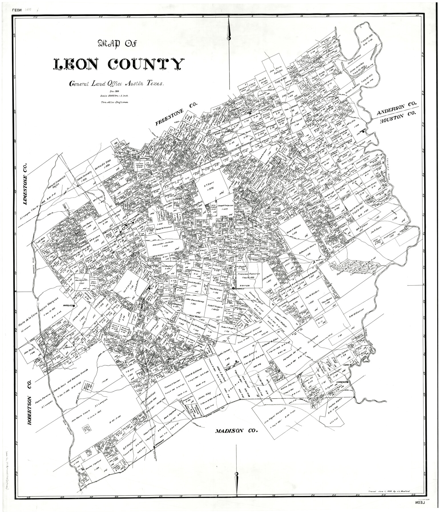
Map of Leon County
-
Map/Doc
66901
-
Collection
General Map Collection
-
Object Dates
12/1916 (Creation Date)
-
People and Organizations
Texas General Land Office (Publisher)
Tom G. Atlee (Draftsman)
Tom G. Atlee (Compiler)
-
Counties
Leon
-
Subjects
County
-
Height x Width
49.3 x 42.5 inches
125.2 x 108.0 cm
-
Comments
Traced June 1, 1938 by J. L. Woodland.
Part of: General Map Collection
Map of Bexar County

Print $40.00
- Digital $50.00
Map of Bexar County
1845
Size 48.8 x 43.0 inches
Map/Doc 87237
Martin County Working Sketch 11

Print $40.00
- Digital $50.00
Martin County Working Sketch 11
1971
Size 49.8 x 38.1 inches
Map/Doc 70829
Current Miscellaneous File 82

Print $4.00
- Digital $50.00
Current Miscellaneous File 82
Size 12.0 x 8.8 inches
Map/Doc 74224
Flight Mission No. BRA-7M, Frame 13, Jefferson County

Print $20.00
- Digital $50.00
Flight Mission No. BRA-7M, Frame 13, Jefferson County
1953
Size 18.6 x 22.4 inches
Map/Doc 85464
Atascosa County Working Sketch 20

Print $20.00
- Digital $50.00
Atascosa County Working Sketch 20
1953
Size 22.9 x 25.5 inches
Map/Doc 67216
[Capitol lands granted for purpose of building State Capitol]
![2073, [Capitol lands granted for purpose of building State Capitol], General Map Collection](https://historictexasmaps.com/wmedia_w700/maps/2073.tif.jpg)
Print $20.00
- Digital $50.00
[Capitol lands granted for purpose of building State Capitol]
1956
Size 31.5 x 13.0 inches
Map/Doc 2073
Swisher County

Print $20.00
- Digital $50.00
Swisher County
1879
Size 21.1 x 18.4 inches
Map/Doc 4064
Bell County Sketch File 21

Print $4.00
- Digital $50.00
Bell County Sketch File 21
1871
Size 8.0 x 9.7 inches
Map/Doc 14410
Travis County Rolled Sketch 28

Print $20.00
- Digital $50.00
Travis County Rolled Sketch 28
1941
Size 22.7 x 27.0 inches
Map/Doc 8030
Encinal County

Print $20.00
- Digital $50.00
Encinal County
1895
Size 34.4 x 24.0 inches
Map/Doc 3516
Galveston County Sketch File 15

Print $4.00
- Digital $50.00
Galveston County Sketch File 15
Size 6.7 x 3.7 inches
Map/Doc 23382
Matagorda County Working Sketch 15

Print $40.00
- Digital $50.00
Matagorda County Working Sketch 15
1954
Size 49.3 x 44.5 inches
Map/Doc 70873
You may also like

Sectional Map of Texas

Print $20.00
- Digital $50.00
Sectional Map of Texas
1909
Size 21.8 x 23.0 inches
Map/Doc 95799
Goliad County Working Sketch 11

Print $20.00
- Digital $50.00
Goliad County Working Sketch 11
1941
Size 38.8 x 40.8 inches
Map/Doc 63201
[Blocks 5-T, R-2, M-24, and M-23]
![91149, [Blocks 5-T, R-2, M-24, and M-23], Twichell Survey Records](https://historictexasmaps.com/wmedia_w700/maps/91149-1.tif.jpg)
Print $20.00
- Digital $50.00
[Blocks 5-T, R-2, M-24, and M-23]
Size 15.5 x 19.7 inches
Map/Doc 91149
Zavala County Sketch File B

Print $34.00
- Digital $50.00
Zavala County Sketch File B
1908
Size 13.5 x 8.9 inches
Map/Doc 41364
[Runnels County School Land and vicinity]
![91686, [Runnels County School Land and vicinity], Twichell Survey Records](https://historictexasmaps.com/wmedia_w700/maps/91686-1.tif.jpg)
Print $20.00
- Digital $50.00
[Runnels County School Land and vicinity]
1945
Size 17.9 x 12.5 inches
Map/Doc 91686
Refugio County Sketch File 17

Print $6.00
- Digital $50.00
Refugio County Sketch File 17
1902
Size 14.3 x 8.8 inches
Map/Doc 35272
Blanco County Rolled Sketch 3

Print $20.00
- Digital $50.00
Blanco County Rolled Sketch 3
Size 14.8 x 13.5 inches
Map/Doc 5142
Working Sketch in Gray, Donley, and Carson Counties, Texas

Print $20.00
- Digital $50.00
Working Sketch in Gray, Donley, and Carson Counties, Texas
1909
Size 22.7 x 27.0 inches
Map/Doc 90779

Flight Mission No. DIX-10P, Frame 75, Aransas County

Print $20.00
- Digital $50.00
Flight Mission No. DIX-10P, Frame 75, Aransas County
1956
Size 18.6 x 22.3 inches
Map/Doc 83936
Brooks County Working Sketch 14

Print $20.00
- Digital $50.00
Brooks County Working Sketch 14
1944
Size 29.2 x 20.0 inches
Map/Doc 67798