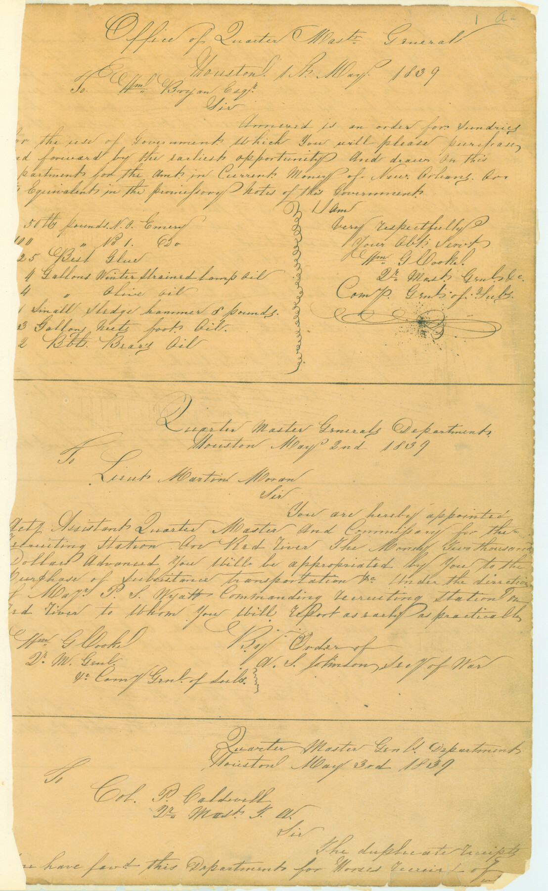
Republic of Texas Muster Roll
-
Map/Doc
94246
-
Collection
Historical Volumes
-
Subjects
Bound Volume Republic of Texas
-
Height x Width
19.5 x 12.0 inches
49.5 x 30.5 cm
-
Medium
paper, bound volume
-
Comments
The muster rolls represent lists of soldiers and the various regiments and companies in which they served during the Texan War of Independence.
Part of: Historical Volumes
Minutes of the Ayuntamiento of San Felipe de Austin Vol. 1

Minutes of the Ayuntamiento of San Felipe de Austin Vol. 1
Size 13.9 x 10.6 inches
Map/Doc 94260
Atlas B, 1-137, Burnet's Colony

Atlas B, 1-137, Burnet's Colony
Size 13.2 x 18.1 inches
Map/Doc 94537
Acts of the Visit of the Royal Commissioners (sometimes referred to as the “Visita General”) - Mier

Acts of the Visit of the Royal Commissioners (sometimes referred to as the “Visita General”) - Mier
1767
Size 14.0 x 9.2 inches
Map/Doc 94257
English Field Notes of the Spanish Archives - Book 4 & W

English Field Notes of the Spanish Archives - Book 4 & W
1836
Map/Doc 96530


English Field Notes of the Spanish Archives - Book Lockhart

English Field Notes of the Spanish Archives - Book Lockhart
1832
Map/Doc 96539
Translations of Titles - Austin's Second Contract, Vol. 3

Translations of Titles - Austin's Second Contract, Vol. 3
1841
Map/Doc 94548
General Land Office Reference Book: Burnet's, Vehlein's, Zavala's, Robertson's Colonies in Texas

General Land Office Reference Book: Burnet's, Vehlein's, Zavala's, Robertson's Colonies in Texas
Map/Doc 94555
English Field Notes of the Spanish Archives - Book A-B

English Field Notes of the Spanish Archives - Book A-B
1835
Map/Doc 96540
Index to Titles, Field, Notes, and Plats, A-Z

Index to Titles, Field, Notes, and Plats, A-Z
Size 17.0 x 12.1 inches
Map/Doc 94525
Record of Translations of Titles - DeWitt's Colony, Vol. 4

Record of Translations of Titles - DeWitt's Colony, Vol. 4
1872
Map/Doc 94549
You may also like

International boundary between the United States and Mexico in the Rio Grande and Colorado River delineated in accordance with the Treaty of November 23, 1970 - Volume 2

International boundary between the United States and Mexico in the Rio Grande and Colorado River delineated in accordance with the Treaty of November 23, 1970 - Volume 2
1974
Size 25.0 x 35.2 inches
Map/Doc 7641
Controlled Mosaic by Jack Amman Photogrammetric Engineers, Inc - Sheet 34

Print $20.00
- Digital $50.00
Controlled Mosaic by Jack Amman Photogrammetric Engineers, Inc - Sheet 34
1954
Size 20.0 x 24.0 inches
Map/Doc 83487
Presidio County Sketch File 75

Print $30.00
- Digital $50.00
Presidio County Sketch File 75
1946
Size 8.9 x 14.3 inches
Map/Doc 34691
Cooke County Sketch File 3

Print $2.00
- Digital $50.00
Cooke County Sketch File 3
1873
Size 6.3 x 7.7 inches
Map/Doc 19222
[Surveys in the Travis District along the Colorado River]
![3180, [Surveys in the Travis District along the Colorado River], General Map Collection](https://historictexasmaps.com/wmedia_w700/maps/3180.tif.jpg)
Print $2.00
- Digital $50.00
[Surveys in the Travis District along the Colorado River]
1841
Size 7.0 x 7.3 inches
Map/Doc 3180
Bell County Working Sketch 8

Print $20.00
- Digital $50.00
Bell County Working Sketch 8
1954
Size 44.2 x 37.3 inches
Map/Doc 67348
Real County Rolled Sketch 12A

Print $20.00
- Digital $50.00
Real County Rolled Sketch 12A
Size 36.2 x 38.3 inches
Map/Doc 9837
Crockett County Working Sketch 98

Print $20.00
- Digital $50.00
Crockett County Working Sketch 98
1980
Size 42.8 x 35.9 inches
Map/Doc 68431
Somervell County Working Sketch 2

Print $20.00
- Digital $50.00
Somervell County Working Sketch 2
1951
Size 22.4 x 23.8 inches
Map/Doc 63906

Presidio County Working Sketch 11

Print $20.00
- Digital $50.00
Presidio County Working Sketch 11
1941
Size 29.2 x 25.8 inches
Map/Doc 71686