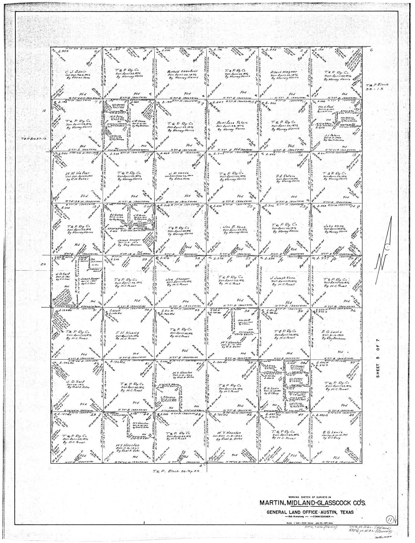
Martin County Working Sketch 11
-
Map/Doc
70829
-
Collection
General Map Collection
-
Object Dates
7/22/1971 (Creation Date)
-
People and Organizations
Herbert H. Ulbricht (Draftsman)
-
Counties
Martin Midland Glasscock
-
Subjects
Surveying Working Sketch
-
Height x Width
49.8 x 38.1 inches
126.5 x 96.8 cm
-
Scale
1" = 400 varas
Part of: General Map Collection
Hardeman County Sketch File 31

Print $4.00
- Digital $50.00
Hardeman County Sketch File 31
Size 14.5 x 9.0 inches
Map/Doc 25066
Crockett County Sketch File 97

Print $20.00
- Digital $50.00
Crockett County Sketch File 97
Size 14.1 x 9.3 inches
Map/Doc 19966
Navarro County Sketch File 11

Print $4.00
- Digital $50.00
Navarro County Sketch File 11
1859
Size 10.4 x 8.2 inches
Map/Doc 32320
Map of Hardin County

Print $20.00
- Digital $50.00
Map of Hardin County
1902
Size 43.8 x 42.3 inches
Map/Doc 4699
Texas Highway Map Points of Interest, Recreational Facilities Guide, Special Events Calendar [Verso]
![94188, Texas Highway Map Points of Interest, Recreational Facilities Guide, Special Events Calendar [Verso], General Map Collection](https://historictexasmaps.com/wmedia_w700/maps/94188.tif.jpg)
Texas Highway Map Points of Interest, Recreational Facilities Guide, Special Events Calendar [Verso]
1963
Size 31.0 x 18.3 inches
Map/Doc 94188
Goliad County Working Sketch 15

Print $20.00
- Digital $50.00
Goliad County Working Sketch 15
1948
Size 42.9 x 43.6 inches
Map/Doc 63205
Morris County Rolled Sketch 2A

Print $20.00
- Digital $50.00
Morris County Rolled Sketch 2A
Size 24.3 x 19.1 inches
Map/Doc 10239
Angelina County Working Sketch 43

Print $20.00
- Digital $50.00
Angelina County Working Sketch 43
1963
Size 23.1 x 34.5 inches
Map/Doc 67126
Young Territory

Print $20.00
- Digital $50.00
Young Territory
1873
Size 29.2 x 29.9 inches
Map/Doc 1976
Limestone County Sketch File 28

Print $54.00
- Digital $50.00
Limestone County Sketch File 28
1986
Size 11.2 x 8.5 inches
Map/Doc 30216
El Paso County Working Sketch 40

Print $20.00
- Digital $50.00
El Paso County Working Sketch 40
1992
Size 21.5 x 24.0 inches
Map/Doc 69062
Flight Mission No. CRK-5P, Frame 160, Refugio County

Print $20.00
- Digital $50.00
Flight Mission No. CRK-5P, Frame 160, Refugio County
1956
Size 18.6 x 22.4 inches
Map/Doc 86941
You may also like
Presidio County Rolled Sketch 84

Print $20.00
- Digital $50.00
Presidio County Rolled Sketch 84
1942
Size 22.7 x 33.1 inches
Map/Doc 9779
General Highway Map, Bailey County, Texas

Print $20.00
General Highway Map, Bailey County, Texas
1961
Size 25.0 x 18.2 inches
Map/Doc 79359
Kinney County Working Sketch 31

Print $20.00
- Digital $50.00
Kinney County Working Sketch 31
1961
Size 30.9 x 47.3 inches
Map/Doc 70213
Parker County Working Sketch 20

Print $20.00
- Digital $50.00
Parker County Working Sketch 20
2005
Map/Doc 83581
Colorado County Working Sketch 10

Print $20.00
- Digital $50.00
Colorado County Working Sketch 10
1940
Size 23.2 x 24.4 inches
Map/Doc 68110
Harris County Historic Topographic 1

Print $20.00
- Digital $50.00
Harris County Historic Topographic 1
1916
Size 29.3 x 22.7 inches
Map/Doc 65811
Flight Mission No. BRA-16M, Frame 182, Jefferson County

Print $20.00
- Digital $50.00
Flight Mission No. BRA-16M, Frame 182, Jefferson County
1953
Size 18.6 x 22.4 inches
Map/Doc 85780
Castro County Sketch File 1

Print $6.00
- Digital $50.00
Castro County Sketch File 1
1890
Size 8.8 x 7.8 inches
Map/Doc 17451
San Patricio County Rolled Sketch 46B

Print $3.00
- Digital $50.00
San Patricio County Rolled Sketch 46B
1983
Size 12.5 x 10.0 inches
Map/Doc 8373
Coryell County Working Sketch 6

Print $20.00
- Digital $50.00
Coryell County Working Sketch 6
1941
Size 15.9 x 13.6 inches
Map/Doc 68213
Flight Mission No. DQO-2K, Frame 151, Galveston County

Print $20.00
- Digital $50.00
Flight Mission No. DQO-2K, Frame 151, Galveston County
1952
Size 18.9 x 22.6 inches
Map/Doc 85048
A Pocket Guide to Austin, Texas - Area Map and Downtown Map

A Pocket Guide to Austin, Texas - Area Map and Downtown Map
Size 17.2 x 20.2 inches
Map/Doc 94386