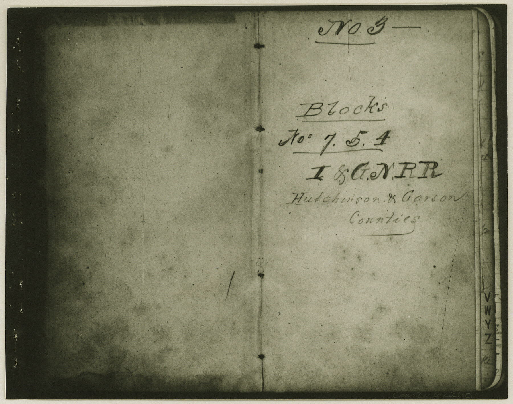
Copy of Surveyor's Field Book, Morris Browning - In Blocks 7, 5 & 4, I&GNRRCo., Hutchinson and Carson Counties, Texas
K-7-70
-
Map/Doc
62260
-
Collection
General Map Collection
-
Object Dates
1888/10/22 (Creation Date)
-
People and Organizations
Morris Browning (Surveyor/Engineer)
-
Counties
Hutchinson Carson
-
Height x Width
6.9 x 8.8 inches
17.5 x 22.4 cm
-
Comments
Copy of Surveyor's field book presented to the General Land Office by Morris Browning on February 3, 1941.
Surveyed from September 14, 1888 to October 22, 1888.
Part of: General Map Collection
Jeff Davis County Sketch File 31

Print $34.00
- Digital $50.00
Jeff Davis County Sketch File 31
Size 10.6 x 8.4 inches
Map/Doc 28023
Reagan County Working Sketch 1

Print $20.00
- Digital $50.00
Reagan County Working Sketch 1
1886
Size 25.0 x 27.3 inches
Map/Doc 71841
Brewster County Rolled Sketch 114

Print $20.00
- Digital $50.00
Brewster County Rolled Sketch 114
1964
Size 11.9 x 18.3 inches
Map/Doc 5290
Hemphill County Working Sketch 17

Print $20.00
- Digital $50.00
Hemphill County Working Sketch 17
1972
Size 33.6 x 45.0 inches
Map/Doc 66112
Amistad International Reservoir on Rio Grande 109

Print $20.00
- Digital $50.00
Amistad International Reservoir on Rio Grande 109
1950
Size 28.6 x 41.3 inches
Map/Doc 75540
San Jacinto County Working Sketch 17

Print $40.00
- Digital $50.00
San Jacinto County Working Sketch 17
1934
Size 36.6 x 48.2 inches
Map/Doc 63730

Oldham County

Print $40.00
- Digital $50.00
Oldham County
1925
Size 40.5 x 52.1 inches
Map/Doc 73254
Webb County Working Sketch 25

Print $20.00
- Digital $50.00
Webb County Working Sketch 25
1928
Size 38.8 x 31.2 inches
Map/Doc 72390
Red River County Sketch File 9

Print $10.00
- Digital $50.00
Red River County Sketch File 9
1862
Size 12.6 x 8.2 inches
Map/Doc 35117
A new and accurate map of North America (wherein the errors of all preceeding British, French and Dutch maps, respecting the rights of Great Britain, France & Spain, & the limits of each of His Majesty's provinces, are corrected)

Print $20.00
- Digital $50.00
A new and accurate map of North America (wherein the errors of all preceeding British, French and Dutch maps, respecting the rights of Great Britain, France & Spain, & the limits of each of His Majesty's provinces, are corrected)
1755
Size 18.3 x 22.1 inches
Map/Doc 97416
Wichita County Working Sketch 5

Print $20.00
- Digital $50.00
Wichita County Working Sketch 5
1913
Size 18.2 x 27.0 inches
Map/Doc 72514
You may also like
Duval County Boundary File 3c

Print $12.00
- Digital $50.00
Duval County Boundary File 3c
Size 11.7 x 8.4 inches
Map/Doc 52732
Flight Mission No. CRC-2R, Frame 113, Chambers County

Print $20.00
- Digital $50.00
Flight Mission No. CRC-2R, Frame 113, Chambers County
1956
Size 18.5 x 22.5 inches
Map/Doc 84740
Flight Mission No. DAG-28K, Frame 31, Matagorda County

Print $20.00
- Digital $50.00
Flight Mission No. DAG-28K, Frame 31, Matagorda County
1953
Size 16.1 x 16.2 inches
Map/Doc 86599
Henderson County Working Sketch 29

Print $20.00
- Digital $50.00
Henderson County Working Sketch 29
1961
Size 39.3 x 41.9 inches
Map/Doc 66162
Throckmorton County Rolled Sketch 5A

Print $20.00
- Digital $50.00
Throckmorton County Rolled Sketch 5A
2001
Size 25.2 x 36.0 inches
Map/Doc 76406
Austin County Rolled Sketch 6

Print $20.00
- Digital $50.00
Austin County Rolled Sketch 6
1951
Size 25.5 x 34.0 inches
Map/Doc 5108
Wellman Townsite Showing Survey 17

Print $3.00
- Digital $50.00
Wellman Townsite Showing Survey 17
Size 12.4 x 11.9 inches
Map/Doc 92885
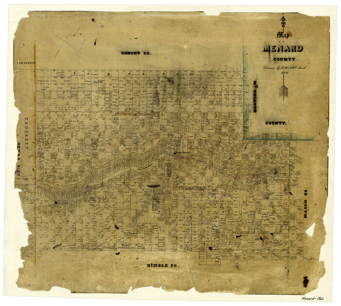
Map of Menard County
Print $20.00
- Digital $50.00
Map of Menard County
1860
Size 20.9 x 23.3 inches
Map/Doc 3874
Garza County Rolled Sketch 5A

Print $40.00
- Digital $50.00
Garza County Rolled Sketch 5A
Size 36.4 x 53.8 inches
Map/Doc 3830
Potter County Sketch File 6A

Print $20.00
- Digital $50.00
Potter County Sketch File 6A
Size 16.7 x 17.3 inches
Map/Doc 12196
Coryell County Sketch File 22

Print $20.00
- Digital $50.00
Coryell County Sketch File 22
1943
Size 24.8 x 18.2 inches
Map/Doc 11186
Throckmorton County Working Sketch Graphic Index

Print $20.00
- Digital $50.00
Throckmorton County Working Sketch Graphic Index
1943
Size 44.6 x 36.3 inches
Map/Doc 76713