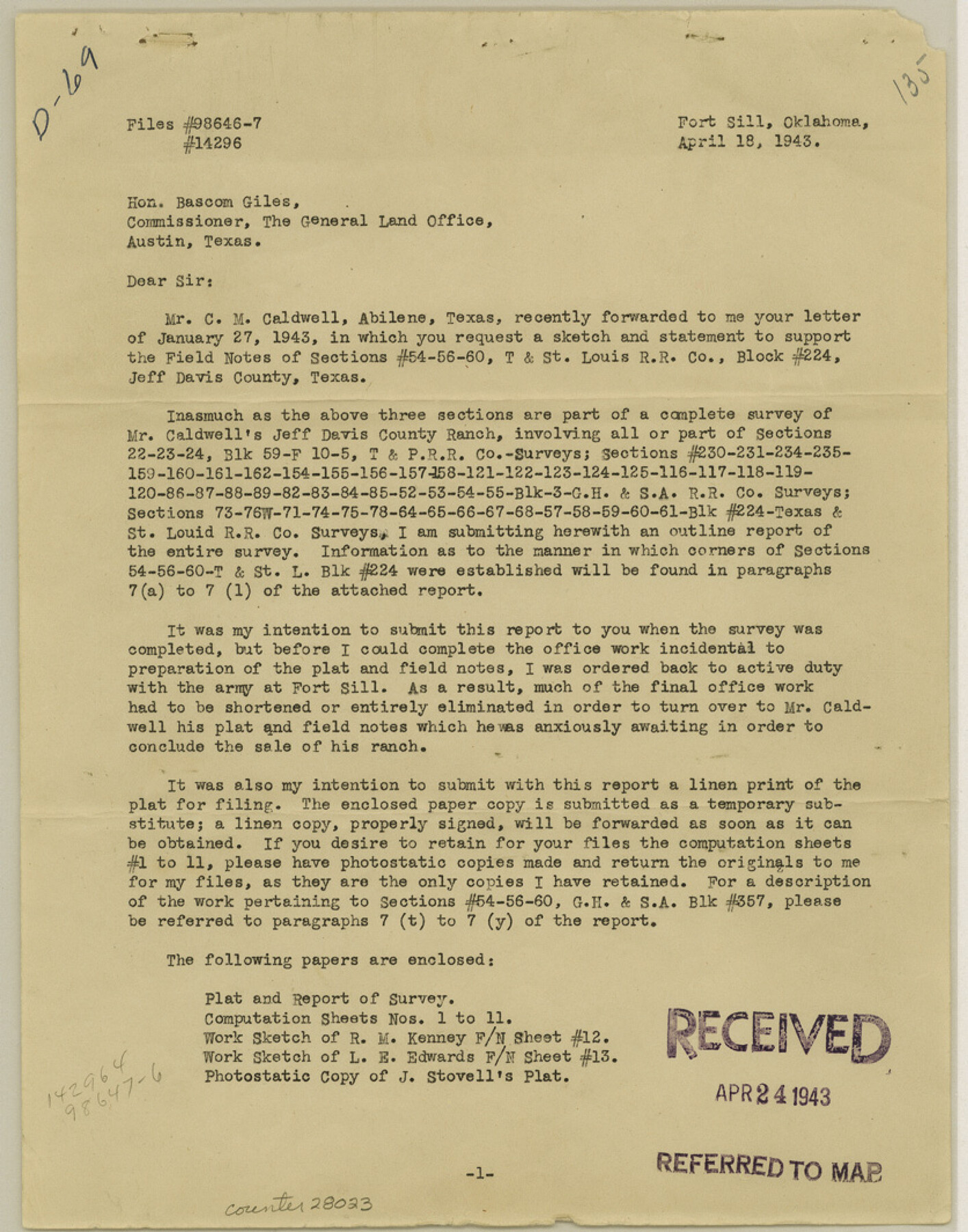
Jeff Davis County Sketch File 31
[Report of surveys in T. & P. Block 59 Township 10-S, G. H. & S. A. Block 3, Tex. Mex. Block 357 and T. & St. L. Block 224]
-
Map/Doc
28023
-
Collection
General Map Collection
-
Object Dates
5/8/1943 (File Date)
4/18/1943 (Correspondence Date)
1907 (Survey Date)
1941 (Survey Date)
-
People and Organizations
Ralph W. Baker (Surveyor/Engineer)
L.E. Edwards (Surveyor/Engineer)
R.M. Kenney (Surveyor/Engineer)
George M. Williams (Surveyor/Engineer)
A.J. Adcock (Surveyor/Engineer)
J.W. Merrill (Surveyor/Engineer)
Jno. Stovell (Surveyor/Engineer)
R.C. Withers (Surveyor/Engineer)
-
Counties
Jeff Davis
-
Subjects
Surveying Sketch File
-
Height x Width
10.6 x 8.4 inches
26.9 x 21.3 cm
-
Medium
paper, print
-
Comments
See Jeff Davis County Rolled Sketch 19A (9266) for sketch.
-
Features
C.M. Caldwell Ranch
Nunn Ranch
Van Horn
Buckley Ranch
A.R. Eppenauer Ranch
Cherry Creek
Related maps
Jeff Davis County Rolled Sketch 19A

Print $20.00
- Digital $50.00
Jeff Davis County Rolled Sketch 19A
Size 33.3 x 39.0 inches
Map/Doc 9266
Part of: General Map Collection

Hale County Boundary File 3

Print $40.00
- Digital $50.00
Hale County Boundary File 3
Size 31.4 x 41.5 inches
Map/Doc 54046
Jefferson County Working Sketch 21

Print $40.00
- Digital $50.00
Jefferson County Working Sketch 21
1969
Size 31.3 x 60.5 inches
Map/Doc 66564
Harris County Sketch File 94

Print $20.00
- Digital $50.00
Harris County Sketch File 94
1952
Size 33.9 x 17.4 inches
Map/Doc 11677
Coke County Sketch File 9

Print $4.00
- Digital $50.00
Coke County Sketch File 9
Size 12.6 x 7.9 inches
Map/Doc 18585
Knox County Boundary File 1a

Print $16.00
- Digital $50.00
Knox County Boundary File 1a
Size 9.7 x 13.8 inches
Map/Doc 65010
Edwards County Sketch File 32 1/2

Print $6.00
- Digital $50.00
Edwards County Sketch File 32 1/2
Size 11.4 x 17.4 inches
Map/Doc 21767
Surveyor's Watercourse Report 1

Print $34.00
Surveyor's Watercourse Report 1
2025
Size 11.0 x 8.5 inches
Map/Doc 97511
Reagan County Rolled Sketch 28

Print $40.00
- Digital $50.00
Reagan County Rolled Sketch 28
1952
Size 64.1 x 46.5 inches
Map/Doc 9823
Brown County State Real Property Sketch 1

Print $80.00
- Digital $50.00
Brown County State Real Property Sketch 1
2018
Size 48.0 x 36.0 inches
Map/Doc 95204
Clay County Boundary File 14

Print $80.00
- Digital $50.00
Clay County Boundary File 14
Size 63.1 x 15.4 inches
Map/Doc 51416
Flight Mission No. BQR-7K, Frame 33, Brazoria County

Print $20.00
- Digital $50.00
Flight Mission No. BQR-7K, Frame 33, Brazoria County
1952
Size 18.7 x 22.3 inches
Map/Doc 84031
You may also like
San Patricio County Sketch File 37

Print $94.00
- Digital $50.00
San Patricio County Sketch File 37
1915
Size 10.5 x 6.4 inches
Map/Doc 36142
University of Texas System University Lands

Print $20.00
- Digital $50.00
University of Texas System University Lands
1972
Size 23.2 x 17.9 inches
Map/Doc 93250
Travis County Sketch File 71

Print $10.00
- Digital $50.00
Travis County Sketch File 71
1840
Size 12.9 x 8.3 inches
Map/Doc 38456
PSL Field Notes for Block B13 in Crane, Ector, Ward, and Winkler Counties, Blocks B14 and B16 in Crane and Ector Counties, Blocks B7 and B8 in Ector and Winkler Counties and Block B15 in Ector County

PSL Field Notes for Block B13 in Crane, Ector, Ward, and Winkler Counties, Blocks B14 and B16 in Crane and Ector Counties, Blocks B7 and B8 in Ector and Winkler Counties and Block B15 in Ector County
Map/Doc 81651
St. Louis, Brownsville & Mexico Railway Location Map from Mile 120 to Rio Grande

Print $40.00
- Digital $50.00
St. Louis, Brownsville & Mexico Railway Location Map from Mile 120 to Rio Grande
1905
Size 20.2 x 61.4 inches
Map/Doc 64169
Bandera County Rolled Sketch 8

Print $20.00
- Digital $50.00
Bandera County Rolled Sketch 8
Size 27.9 x 26.4 inches
Map/Doc 5119
Map of Galveston Bay from Lawrence Cove to Stevenson's Station

Print $20.00
- Digital $50.00
Map of Galveston Bay from Lawrence Cove to Stevenson's Station
1851
Size 35.2 x 29.7 inches
Map/Doc 69921
Flight Mission No. CRC-4R, Frame 162, Chambers County

Print $20.00
- Digital $50.00
Flight Mission No. CRC-4R, Frame 162, Chambers County
1956
Size 18.6 x 22.4 inches
Map/Doc 84921

Ward County Working Sketch 32

Print $40.00
- Digital $50.00
Ward County Working Sketch 32
1967
Size 32.5 x 66.0 inches
Map/Doc 72338
Potter County Sketch File 5

Print $20.00
- Digital $50.00
Potter County Sketch File 5
1890
Size 14.1 x 8.8 inches
Map/Doc 34387
[Area south of Runnels County School Land]
![93168, [Area south of Runnels County School Land], Twichell Survey Records](https://historictexasmaps.com/wmedia_w700/maps/93168-1.tif.jpg)
Print $40.00
- Digital $50.00
[Area south of Runnels County School Land]
Size 87.7 x 42.9 inches
Map/Doc 93168