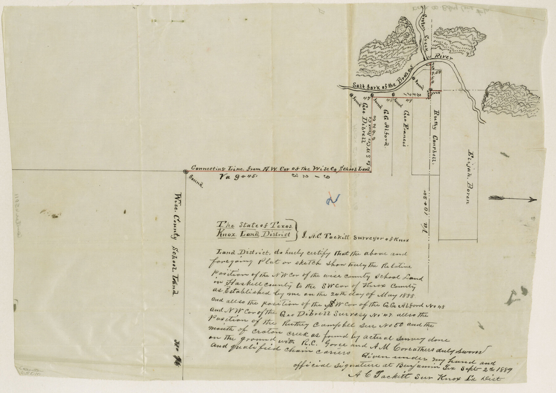
Knox County Boundary File 1a
Knox Co. Connection of the S. W. corner of said County with adjoining surveys
-
Map/Doc
65010
-
Collection
General Map Collection
-
Counties
Knox
-
Subjects
County Boundaries
-
Height x Width
9.7 x 13.8 inches
24.6 x 35.1 cm
Part of: General Map Collection
Childress County Rolled Sketch 9

Print $20.00
- Digital $50.00
Childress County Rolled Sketch 9
Size 19.3 x 22.9 inches
Map/Doc 5446
Nueces County Sketch File 58

Print $162.00
- Digital $50.00
Nueces County Sketch File 58
1981
Size 11.2 x 8.5 inches
Map/Doc 32920
Reagan County Rolled Sketch 19

Print $20.00
- Digital $50.00
Reagan County Rolled Sketch 19
1939
Size 24.0 x 20.5 inches
Map/Doc 7445
Flight Mission No. BQY-4M, Frame 60, Harris County

Print $20.00
- Digital $50.00
Flight Mission No. BQY-4M, Frame 60, Harris County
1953
Size 18.6 x 22.3 inches
Map/Doc 85269
Erath County Sketch File 16

Print $4.00
- Digital $50.00
Erath County Sketch File 16
1872
Size 12.9 x 8.3 inches
Map/Doc 22294
[Missouri, Kansas & Texas] E. L. & R. R. Railroad, Morris Co.
![64273, [Missouri, Kansas & Texas] E. L. & R. R. Railroad, Morris Co., General Map Collection](https://historictexasmaps.com/wmedia_w700/maps/64273.tif.jpg)
Print $20.00
- Digital $50.00
[Missouri, Kansas & Texas] E. L. & R. R. Railroad, Morris Co.
1906
Size 13.1 x 28.4 inches
Map/Doc 64273
Brazos River, Koy Bridge Sheet/Mill Creek

Print $20.00
- Digital $50.00
Brazos River, Koy Bridge Sheet/Mill Creek
1933
Size 44.0 x 27.3 inches
Map/Doc 65290
Brewster County Rolled Sketch 24E

Print $20.00
- Digital $50.00
Brewster County Rolled Sketch 24E
1906
Size 15.2 x 18.1 inches
Map/Doc 5212
Kerr County Working Sketch 11

Print $20.00
- Digital $50.00
Kerr County Working Sketch 11
1951
Size 30.3 x 29.9 inches
Map/Doc 70042
Van Zandt County Working Sketch 6a

Print $40.00
- Digital $50.00
Van Zandt County Working Sketch 6a
1941
Size 57.6 x 30.1 inches
Map/Doc 72255
Sulphur River, Bassett Sheet

Print $20.00
- Digital $50.00
Sulphur River, Bassett Sheet
1939
Size 24.8 x 32.0 inches
Map/Doc 78322

You may also like
Castro County Sketch File 4m

Print $4.00
- Digital $50.00
Castro County Sketch File 4m
Size 13.6 x 8.6 inches
Map/Doc 17489
Shackelford County Sketch File 16

Print $24.00
- Digital $50.00
Shackelford County Sketch File 16
2005
Size 16.0 x 16.0 inches
Map/Doc 82982
Presidio County Sketch File E

Print $20.00
- Digital $50.00
Presidio County Sketch File E
Size 15.9 x 20.0 inches
Map/Doc 11702
Grayson County Boundary File 4

Print $16.00
- Digital $50.00
Grayson County Boundary File 4
Size 12.7 x 8.0 inches
Map/Doc 53948
Fractional Township No. 7 South Range No. 4 East of the Indian Meridian, Indian Territory

Print $20.00
- Digital $50.00
Fractional Township No. 7 South Range No. 4 East of the Indian Meridian, Indian Territory
1898
Size 19.3 x 24.4 inches
Map/Doc 75207
Trace of a copy of the map captured at the battle of Resaca de la Palma

Print $20.00
- Digital $50.00
Trace of a copy of the map captured at the battle of Resaca de la Palma
Size 18.4 x 27.4 inches
Map/Doc 73055
San Saba County

Print $20.00
- Digital $50.00
San Saba County
1987
Size 43.5 x 47.3 inches
Map/Doc 95635
San Patricio County Sketch File 39

Print $8.00
- Digital $50.00
San Patricio County Sketch File 39
Size 12.9 x 8.4 inches
Map/Doc 36232
Harris County Working Sketch 102

Print $20.00
- Digital $50.00
Harris County Working Sketch 102
1980
Size 33.6 x 18.9 inches
Map/Doc 65994
Archer County Working Sketch 1a

Print $20.00
- Digital $50.00
Archer County Working Sketch 1a
Size 42.8 x 42.5 inches
Map/Doc 83096
Comal County Rolled Sketch 1

Print $20.00
- Digital $50.00
Comal County Rolled Sketch 1
1972
Size 24.2 x 19.6 inches
Map/Doc 5535
[Leagues 615, 616, and vicinity]
![91004, [Leagues 615, 616, and vicinity], Twichell Survey Records](https://historictexasmaps.com/wmedia_w700/maps/91004-1.tif.jpg)
Print $20.00
- Digital $50.00
[Leagues 615, 616, and vicinity]
Size 12.9 x 12.3 inches
Map/Doc 91004