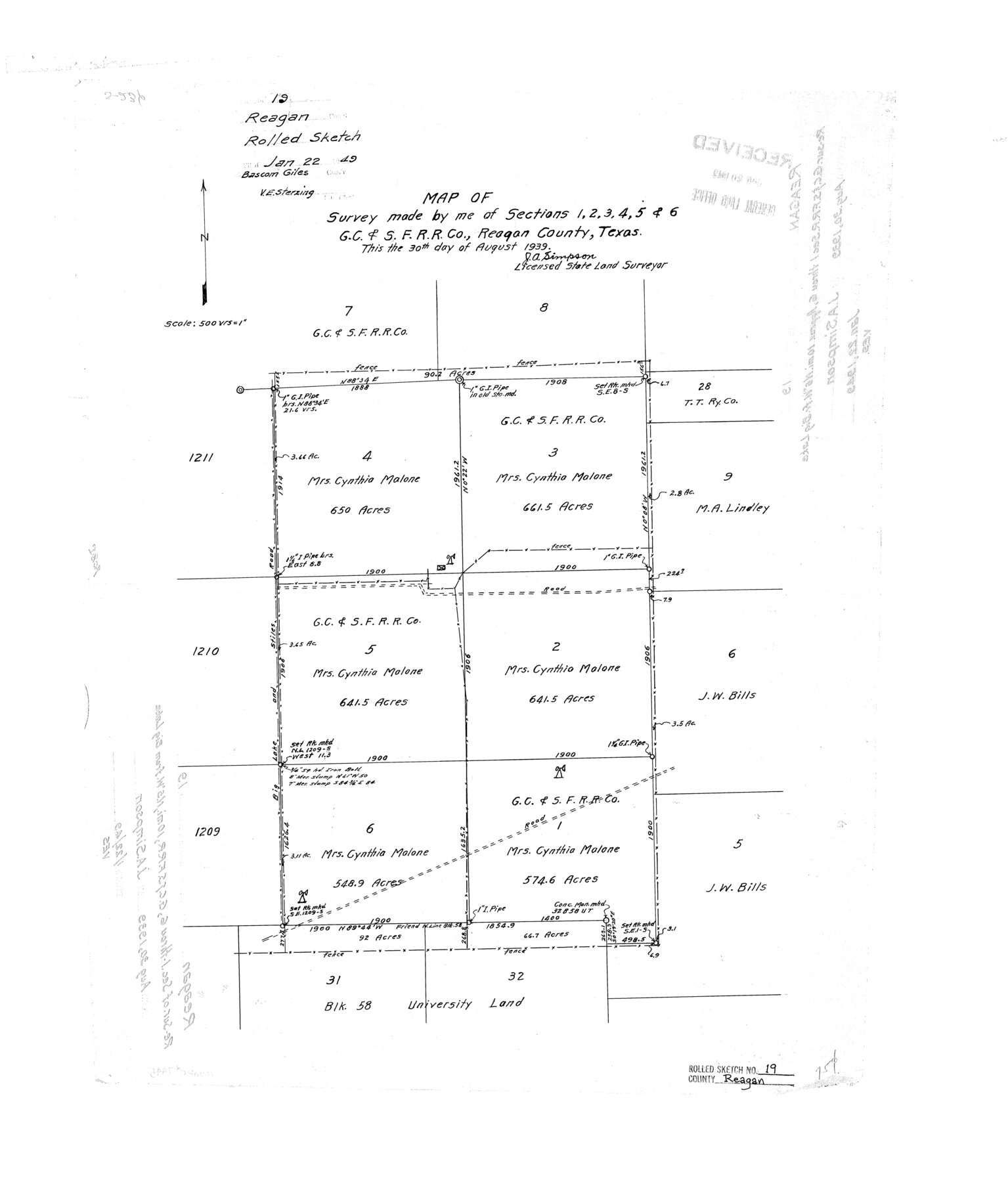
Reagan County Rolled Sketch 19
Map of survey made by me of sections 1, 2, 3, 4, 5, & 6, G. C. & S. F. R.R. Co., Reagan County, Texas
-
Map/Doc
7445
-
Collection
General Map Collection
-
Object Dates
1939/8/30 (Creation Date)
1949/1/22 (File Date)
-
People and Organizations
J.A. Simpson (Surveyor/Engineer)
-
Counties
Reagan
-
Subjects
Cadastral Surveying Rolled Sketch
-
Height x Width
24.0 x 20.5 inches
61.0 x 52.1 cm
-
Scale
1" = 500 varas
Part of: General Map Collection
[Ft. W. & R. G. Ry. Right of Way Map, Chapin to Bluffdale, Hood County, Texas]
![64644, [Ft. W. & R. G. Ry. Right of Way Map, Chapin to Bluffdale, Hood County, Texas], General Map Collection](https://historictexasmaps.com/wmedia_w700/maps/64644.tif.jpg)
Print $40.00
- Digital $50.00
[Ft. W. & R. G. Ry. Right of Way Map, Chapin to Bluffdale, Hood County, Texas]
1918
Size 37.7 x 84.3 inches
Map/Doc 64644
Howard County Sketch File 10
![11798, Howard County Sketch File 10, General Map Collection](https://historictexasmaps.com/wmedia_w700/pdf_converted_jpg/qi_pdf_thumbnail_8204.jpg)
Print $20.00
- Digital $50.00
Howard County Sketch File 10
Size 22.5 x 22.0 inches
Map/Doc 11798
Brazoria County Working Sketch 51
![83628, Brazoria County Working Sketch 51, General Map Collection](https://historictexasmaps.com/wmedia_w700/maps/83628.tif.jpg)
Print $20.00
- Digital $50.00
Brazoria County Working Sketch 51
2006
Size 34.0 x 38.0 inches
Map/Doc 83628
Hood County Rolled Sketch 6A
![6223, Hood County Rolled Sketch 6A, General Map Collection](https://historictexasmaps.com/wmedia_w700/maps/6223.tif.jpg)
Print $4.00
- Digital $50.00
Hood County Rolled Sketch 6A
1996
Size 19.9 x 26.5 inches
Map/Doc 6223
Zavala County Sketch File 21
![41376, Zavala County Sketch File 21, General Map Collection](https://historictexasmaps.com/wmedia_w700/pdf_converted_jpg/qi_pdf_thumbnail_15247.jpg)
Print $4.00
- Digital $50.00
Zavala County Sketch File 21
1915
Size 11.5 x 8.8 inches
Map/Doc 41376
Copy of Surveyor's Field Book, Morris Browning - In Blocks 7, 5 & 4, I&GNRRCo., Hutchinson and Carson Counties, Texas
![62286, Copy of Surveyor's Field Book, Morris Browning - In Blocks 7, 5 & 4, I&GNRRCo., Hutchinson and Carson Counties, Texas, General Map Collection](https://historictexasmaps.com/wmedia_w700/maps/62286.tif.jpg)
Print $2.00
- Digital $50.00
Copy of Surveyor's Field Book, Morris Browning - In Blocks 7, 5 & 4, I&GNRRCo., Hutchinson and Carson Counties, Texas
1888
Size 7.0 x 8.8 inches
Map/Doc 62286
Mason County Working Sketch 23
![83577, Mason County Working Sketch 23, General Map Collection](https://historictexasmaps.com/wmedia_w700/maps/83577.tif.jpg)
Print $20.00
- Digital $50.00
Mason County Working Sketch 23
2004
Size 17.4 x 36.9 inches
Map/Doc 83577
Aransas County Rolled Sketch 31
![77498, Aransas County Rolled Sketch 31, General Map Collection](https://historictexasmaps.com/wmedia_w700/maps/77498.tif.jpg)
Print $20.00
- Digital $50.00
Aransas County Rolled Sketch 31
1986
Size 30.0 x 41.4 inches
Map/Doc 77498
Flight Mission No. DCL-7C, Frame 43, Kenedy County
![86031, Flight Mission No. DCL-7C, Frame 43, Kenedy County, General Map Collection](https://historictexasmaps.com/wmedia_w700/pdf_converted_jpg/qi_pdf_thumbnail_33177.jpg)
Print $20.00
- Digital $50.00
Flight Mission No. DCL-7C, Frame 43, Kenedy County
1943
Size 15.5 x 15.5 inches
Map/Doc 86031
Lubbock County Working Sketch 8
![70668, Lubbock County Working Sketch 8, General Map Collection](https://historictexasmaps.com/wmedia_w700/maps/70668.tif.jpg)
Print $20.00
- Digital $50.00
Lubbock County Working Sketch 8
Size 27.4 x 25.2 inches
Map/Doc 70668
Llano County Sketch File 18
![12013, Llano County Sketch File 18, General Map Collection](https://historictexasmaps.com/wmedia_w700/pdf_converted_jpg/qi_pdf_thumbnail_8372.jpg)
Print $20.00
- Digital $50.00
Llano County Sketch File 18
1949
Size 22.3 x 20.0 inches
Map/Doc 12013
You may also like
General Highway Map, Gonzales County, Texas
![79102, General Highway Map, Gonzales County, Texas, Texas State Library and Archives](https://historictexasmaps.com/wmedia_w700/maps/79102.tif.jpg)
Print $20.00
General Highway Map, Gonzales County, Texas
1940
Size 18.6 x 25.0 inches
Map/Doc 79102
Fort Bend County State Real Property Sketch 4
![61678, Fort Bend County State Real Property Sketch 4, General Map Collection](https://historictexasmaps.com/wmedia_w700/pdf_converted_jpg/qi_pdf_thumbnail_17197.jpg)
Print $40.00
- Digital $50.00
Fort Bend County State Real Property Sketch 4
1987
Size 36.3 x 47.9 inches
Map/Doc 61678
Survey and Location of the Corpus Christi & Rio Grande Railway Under Charter of May 24th 1873
![64092, Survey and Location of the Corpus Christi & Rio Grande Railway Under Charter of May 24th 1873, General Map Collection](https://historictexasmaps.com/wmedia_w700/maps/64092.tif.jpg)
Print $40.00
- Digital $50.00
Survey and Location of the Corpus Christi & Rio Grande Railway Under Charter of May 24th 1873
1874
Size 12.5 x 58.7 inches
Map/Doc 64092
[Capitol Leagues Eastward from Bl, LC2 to H. & T.C. Blk. 44]
![89921, [Capitol Leagues Eastward from Bl, LC2 to H. & T.C. Blk. 44], Twichell Survey Records](https://historictexasmaps.com/wmedia_w700/maps/89921-1.tif.jpg)
Print $40.00
- Digital $50.00
[Capitol Leagues Eastward from Bl, LC2 to H. & T.C. Blk. 44]
Size 64.0 x 41.9 inches
Map/Doc 89921
Erath County Sketch File 8a
![22271, Erath County Sketch File 8a, General Map Collection](https://historictexasmaps.com/wmedia_w700/pdf_converted_jpg/qi_pdf_thumbnail_11028.jpg)
Print $6.00
- Digital $50.00
Erath County Sketch File 8a
1853
Size 15.9 x 11.0 inches
Map/Doc 22271
Panola County Sketch File 25
![12140, Panola County Sketch File 25, General Map Collection](https://historictexasmaps.com/wmedia_w700/pdf_converted_jpg/qi_pdf_thumbnail_8480.jpg)
Print $20.00
- Digital $50.00
Panola County Sketch File 25
1946
Size 24.1 x 21.4 inches
Map/Doc 12140
Aransas Migratory Waterfowl Refuge in Aransas and Refugio Counties
![2693, Aransas Migratory Waterfowl Refuge in Aransas and Refugio Counties, General Map Collection](https://historictexasmaps.com/wmedia_w700/maps/2693.tif.jpg)
Print $20.00
- Digital $50.00
Aransas Migratory Waterfowl Refuge in Aransas and Refugio Counties
1937
Size 40.3 x 31.0 inches
Map/Doc 2693
Schleicher County Sketch File 27
![12305, Schleicher County Sketch File 27, General Map Collection](https://historictexasmaps.com/wmedia_w700/pdf_converted_jpg/qi_pdf_thumbnail_8629.jpg)
Print $20.00
- Digital $50.00
Schleicher County Sketch File 27
Size 23.0 x 19.2 inches
Map/Doc 12305
Smith County Working Sketch 8
![63893, Smith County Working Sketch 8, General Map Collection](https://historictexasmaps.com/wmedia_w700/maps/63893.tif.jpg)
Print $20.00
- Digital $50.00
Smith County Working Sketch 8
Size 28.9 x 22.7 inches
Map/Doc 63893
Chart of the Harbour of San [Luis]
![72763, Chart of the Harbour of San [Luis], General Map Collection](https://historictexasmaps.com/wmedia_w700/maps/72763.tif.jpg)
Print $20.00
- Digital $50.00
Chart of the Harbour of San [Luis]
1846
Size 27.7 x 18.3 inches
Map/Doc 72763
Schleicher County Sketch File 41
![36544, Schleicher County Sketch File 41, General Map Collection](https://historictexasmaps.com/wmedia_w700/pdf_converted_jpg/qi_pdf_thumbnail_14164.jpg)
Print $6.00
- Digital $50.00
Schleicher County Sketch File 41
1963
Size 16.2 x 9.9 inches
Map/Doc 36544
Wise County, Texas
![767, Wise County, Texas, Maddox Collection](https://historictexasmaps.com/wmedia_w700/maps/767-1.tif.jpg)
Print $20.00
- Digital $50.00
Wise County, Texas
1870
Size 20.9 x 18.0 inches
Map/Doc 767