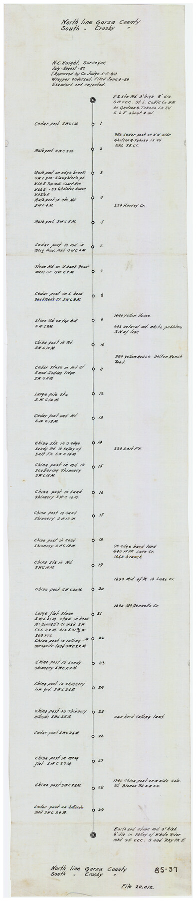
North Line Garza County/South Line Crosby County
85-37
-
Map/Doc
90904
-
Collection
Twichell Survey Records
-
Object Dates
8/1887 (Creation Date)
-
People and Organizations
H.C. Knight (Surveyor/Engineer)
-
Counties
Garza Crosby
-
Height x Width
8.3 x 35.1 inches
21.1 x 89.2 cm
-
Comments
Note on map says "Examined and Rejected"
Part of: Twichell Survey Records
[Township 3 North, Block 33]
![91215, [Township 3 North, Block 33], Twichell Survey Records](https://historictexasmaps.com/wmedia_w700/maps/91215-1.tif.jpg)
Print $3.00
- Digital $50.00
[Township 3 North, Block 33]
Size 11.2 x 17.0 inches
Map/Doc 91215
Part of Fisher County [around Bastrop County School Land Leagues 313 and 314, Thos. H. Cosby League 315 and El Paso County School Land League 316]
![90820, Part of Fisher County [around Bastrop County School Land Leagues 313 and 314, Thos. H. Cosby League 315 and El Paso County School Land League 316], Twichell Survey Records](https://historictexasmaps.com/wmedia_w700/maps/90820-2.tif.jpg)
Print $20.00
- Digital $50.00
Part of Fisher County [around Bastrop County School Land Leagues 313 and 314, Thos. H. Cosby League 315 and El Paso County School Land League 316]
1883
Size 20.0 x 24.7 inches
Map/Doc 90820
[East Line and Red River Railroad Company, Block Z and vicinity]
![91256, [East Line and Red River Railroad Company, Block Z and vicinity], Twichell Survey Records](https://historictexasmaps.com/wmedia_w700/maps/91256-1.tif.jpg)
Print $20.00
- Digital $50.00
[East Line and Red River Railroad Company, Block Z and vicinity]
1878
Size 27.8 x 22.1 inches
Map/Doc 91256
[J. Blackwell survey 150, E. Parker, Asa Dorsett survey 827 and surrounding surveys]
![90422, [J. Blackwell survey 150, E. Parker, Asa Dorsett survey 827 and surrounding surveys], Twichell Survey Records](https://historictexasmaps.com/wmedia_w700/maps/90422-1.tif.jpg)
Print $20.00
- Digital $50.00
[J. Blackwell survey 150, E. Parker, Asa Dorsett survey 827 and surrounding surveys]
Size 35.0 x 30.3 inches
Map/Doc 90422
[Part of Blocks 34 and 35, Township 3 North]
![91287, [Part of Blocks 34 and 35, Township 3 North], Twichell Survey Records](https://historictexasmaps.com/wmedia_w700/maps/91287-1.tif.jpg)
Print $20.00
- Digital $50.00
[Part of Blocks 34 and 35, Township 3 North]
Size 12.7 x 13.5 inches
Map/Doc 91287
Map of Independence Area, Washington County, Texas

Print $20.00
- Digital $50.00
Map of Independence Area, Washington County, Texas
1935
Size 18.6 x 16.5 inches
Map/Doc 92093
Littlefield, Lamb County, Texas

Print $20.00
- Digital $50.00
Littlefield, Lamb County, Texas
Size 42.4 x 38.0 inches
Map/Doc 89966
[Sketch from Paul McCombs Map of 1884, showing T. & P. Township 5, Block 60, Township 6, Block 59, and Township 7, Blocks 59 and 60]
![91774, [Sketch from Paul McCombs Map of 1884, showing T. & P. Township 5, Block 60, Township 6, Block 59, and Township 7, Blocks 59 and 60], Twichell Survey Records](https://historictexasmaps.com/wmedia_w700/maps/91774-1.tif.jpg)
Print $2.00
- Digital $50.00
[Sketch from Paul McCombs Map of 1884, showing T. & P. Township 5, Block 60, Township 6, Block 59, and Township 7, Blocks 59 and 60]
Size 9.2 x 15.0 inches
Map/Doc 91774
Section P Tech Memorial Park, Inc.

Print $20.00
- Digital $50.00
Section P Tech Memorial Park, Inc.
1953
Size 21.1 x 32.3 inches
Map/Doc 92353
Ellis Addition to the City of Lubbock, Being a Subdivision of a Part of the SW/4 of SW/4 Sec. 4, Blk. A

Print $3.00
- Digital $50.00
Ellis Addition to the City of Lubbock, Being a Subdivision of a Part of the SW/4 of SW/4 Sec. 4, Blk. A
1952
Size 9.5 x 12.0 inches
Map/Doc 92710
Brazos River Conservation and Reclamation District Official Boundary Line Survey, Parmer County

Print $20.00
- Digital $50.00
Brazos River Conservation and Reclamation District Official Boundary Line Survey, Parmer County
Size 24.9 x 36.9 inches
Map/Doc 91599
[Sketch showing H. and T. C. Blocks 46 and 47]
![91735, [Sketch showing H. and T. C. Blocks 46 and 47], Twichell Survey Records](https://historictexasmaps.com/wmedia_w700/maps/91735-1.tif.jpg)
Print $20.00
- Digital $50.00
[Sketch showing H. and T. C. Blocks 46 and 47]
1884
Size 38.5 x 24.7 inches
Map/Doc 91735
You may also like
Foard County Working Sketch 3

Print $20.00
- Digital $50.00
Foard County Working Sketch 3
1933
Size 21.1 x 18.8 inches
Map/Doc 69193
Stonewall County Working Sketch 9

Print $20.00
- Digital $50.00
Stonewall County Working Sketch 9
1950
Size 27.9 x 34.1 inches
Map/Doc 62316
Texas State Boundary Line 7

Print $182.00
Texas State Boundary Line 7
2000
Size 11.2 x 8.8 inches
Map/Doc 75018
Mason County Working Sketch 23

Print $20.00
- Digital $50.00
Mason County Working Sketch 23
2004
Size 17.4 x 36.9 inches
Map/Doc 83577
Irion County Rolled Sketch 20

Print $20.00
- Digital $50.00
Irion County Rolled Sketch 20
1936
Size 26.3 x 42.7 inches
Map/Doc 6329
Travis County Sketch File 70

Print $26.00
- Digital $50.00
Travis County Sketch File 70
1961
Size 14.4 x 8.8 inches
Map/Doc 38453
Leon County Working Sketch 61

Print $20.00
- Digital $50.00
Leon County Working Sketch 61
2010
Size 35.8 x 38.7 inches
Map/Doc 89986
Flight Mission No. DCL-6C, Frame 120, Kenedy County

Print $20.00
- Digital $50.00
Flight Mission No. DCL-6C, Frame 120, Kenedy County
1943
Size 18.4 x 22.3 inches
Map/Doc 85950
Flight Mission No. BRA-7M, Frame 208, Jefferson County

Print $20.00
- Digital $50.00
Flight Mission No. BRA-7M, Frame 208, Jefferson County
1953
Size 18.5 x 22.3 inches
Map/Doc 85576
Comal County Sketch File 6

Print $6.00
- Digital $50.00
Comal County Sketch File 6
Size 10.3 x 8.1 inches
Map/Doc 19008
Kendall County Working Sketch 29

Print $20.00
- Digital $50.00
Kendall County Working Sketch 29
2025
Map/Doc 97408
Andrews County Sketch File 1

Print $6.00
- Digital $50.00
Andrews County Sketch File 1
Size 9.0 x 13.6 inches
Map/Doc 12818