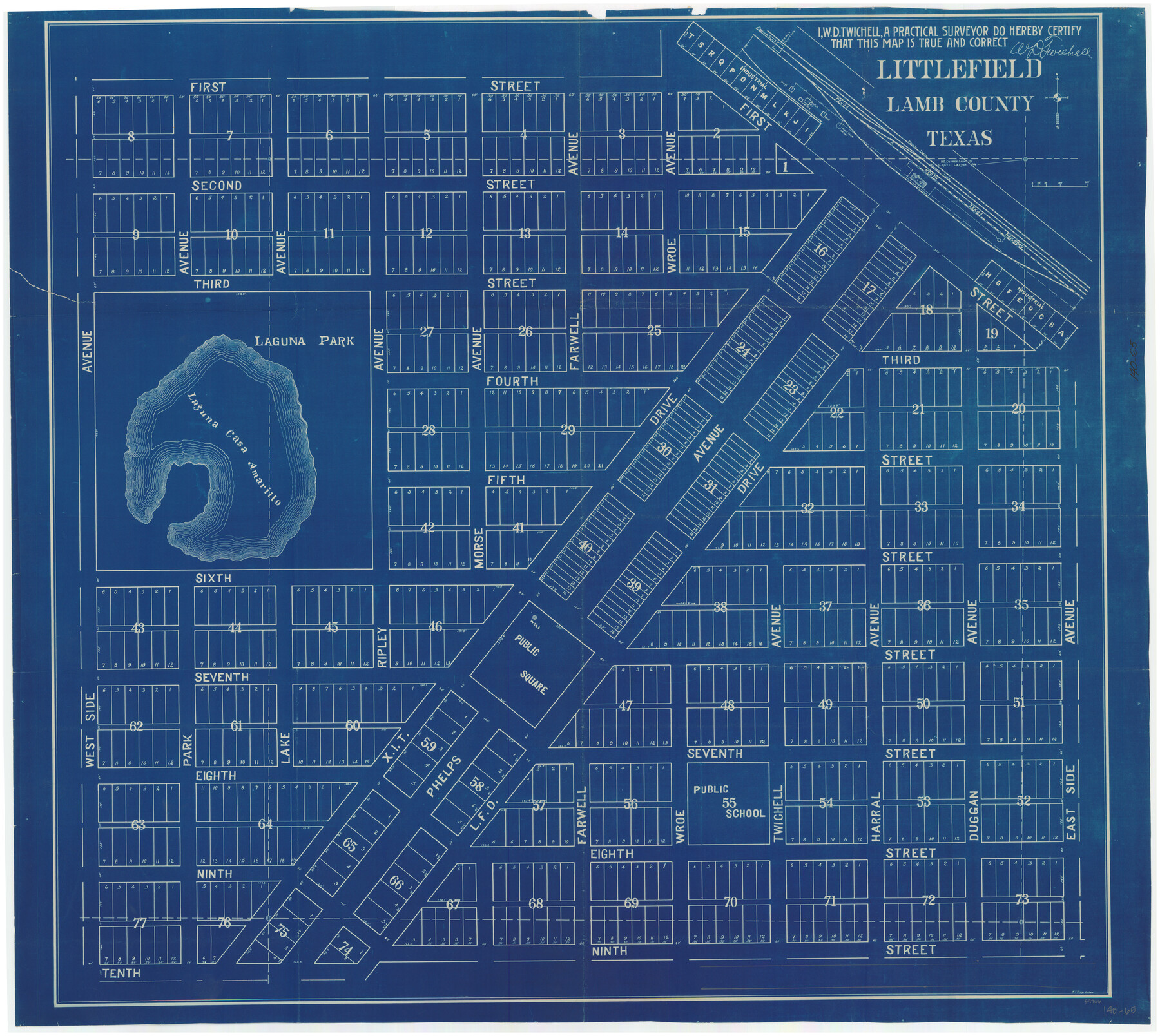
Littlefield, Lamb County, Texas
140-65
-
Map/Doc
89966
-
Collection
Twichell Survey Records
-
People and Organizations
W.D. Twichell (Surveyor/Engineer)
Howard T. Trigg (Surveyor/Engineer)
-
Counties
Lamb
-
Height x Width
42.4 x 38.0 inches
107.7 x 96.5 cm
Part of: Twichell Survey Records
[Surveys to the North and West of the Francis Blundell survey containing townsite]
![90884, [Surveys to the North and West of the Francis Blundell survey containing townsite], Twichell Survey Records](https://historictexasmaps.com/wmedia_w700/maps/90884-1.tif.jpg)
Print $20.00
- Digital $50.00
[Surveys to the North and West of the Francis Blundell survey containing townsite]
Size 26.3 x 19.8 inches
Map/Doc 90884
[Block 1 PO, Surveys 15, 16, and 17]
![91433, [Block 1 PO, Surveys 15, 16, and 17], Twichell Survey Records](https://historictexasmaps.com/wmedia_w700/maps/91433-1.tif.jpg)
Print $20.00
- Digital $50.00
[Block 1 PO, Surveys 15, 16, and 17]
1906
Size 16.6 x 15.6 inches
Map/Doc 91433
[Blotter for Roads in Moore County]
![91530, [Blotter for Roads in Moore County], Twichell Survey Records](https://historictexasmaps.com/wmedia_w700/maps/91530-1.tif.jpg)
Print $20.00
- Digital $50.00
[Blotter for Roads in Moore County]
Size 32.5 x 32.0 inches
Map/Doc 91530
[Sketch around Falls County School Land and surveys to South]
![91886, [Sketch around Falls County School Land and surveys to South], Twichell Survey Records](https://historictexasmaps.com/wmedia_w700/maps/91886-1.tif.jpg)
Print $20.00
- Digital $50.00
[Sketch around Falls County School Land and surveys to South]
1894
Size 13.1 x 12.1 inches
Map/Doc 91886
Working Sketch in Bastrop County

Print $20.00
- Digital $50.00
Working Sketch in Bastrop County
1923
Size 32.6 x 37.9 inches
Map/Doc 90147
[Part of Block K11, Leagues 346, 357 1/2, 367]
![90530, [Part of Block K11, Leagues 346, 357 1/2, 367], Twichell Survey Records](https://historictexasmaps.com/wmedia_w700/maps/90530-1.tif.jpg)
Print $2.00
- Digital $50.00
[Part of Block K11, Leagues 346, 357 1/2, 367]
Size 7.3 x 11.6 inches
Map/Doc 90530
[Roosevelt, Quay, and other Counties, N.M.]
![89820, [Roosevelt, Quay, and other Counties, N.M.], Twichell Survey Records](https://historictexasmaps.com/wmedia_w700/maps/89820-1.tif.jpg)
Print $40.00
- Digital $50.00
[Roosevelt, Quay, and other Counties, N.M.]
Size 40.7 x 57.6 inches
Map/Doc 89820
[Strip along North line of Glasscock County School Land]
![90556, [Strip along North line of Glasscock County School Land], Twichell Survey Records](https://historictexasmaps.com/wmedia_w700/maps/90556-1.tif.jpg)
Print $2.00
- Digital $50.00
[Strip along North line of Glasscock County School Land]
Size 4.3 x 6.5 inches
Map/Doc 90556
Gregg County School Land League 2

Print $20.00
- Digital $50.00
Gregg County School Land League 2
Size 15.6 x 15.5 inches
Map/Doc 90613
[Sketch Showing Connections from Jeremiah McDonald resurvey]
![91154, [Sketch Showing Connections from Jeremiah McDonald resurvey], Twichell Survey Records](https://historictexasmaps.com/wmedia_w700/maps/91154-1.tif.jpg)
Print $20.00
- Digital $50.00
[Sketch Showing Connections from Jeremiah McDonald resurvey]
Size 21.6 x 14.5 inches
Map/Doc 91154
[Sketch of Blocks D5-D8]
![93046, [Sketch of Blocks D5-D8], Twichell Survey Records](https://historictexasmaps.com/wmedia_w700/maps/93046-1.tif.jpg)
Print $20.00
- Digital $50.00
[Sketch of Blocks D5-D8]
Size 43.1 x 28.3 inches
Map/Doc 93046
Working Sketch in Crosby Co.

Print $20.00
- Digital $50.00
Working Sketch in Crosby Co.
1906
Size 17.5 x 17.9 inches
Map/Doc 90350
You may also like
Kerr County Rolled Sketch 10

Print $20.00
- Digital $50.00
Kerr County Rolled Sketch 10
1946
Size 20.7 x 26.2 inches
Map/Doc 6494

Flight Mission No. DQN-2K, Frame 137, Calhoun County

Print $20.00
- Digital $50.00
Flight Mission No. DQN-2K, Frame 137, Calhoun County
1953
Size 18.8 x 22.5 inches
Map/Doc 84306
General Highway Map. Detail of Cities and Towns in Travis County, Texas

Print $20.00
General Highway Map. Detail of Cities and Towns in Travis County, Texas
1961
Size 18.2 x 24.8 inches
Map/Doc 79682
Colorado County Sketch File 17

Print $22.00
- Digital $50.00
Colorado County Sketch File 17
Size 8.7 x 7.7 inches
Map/Doc 18949
J. De Cordova's Map of the State of Texas Compiled from the records of the General Land Office of the State

Print $20.00
J. De Cordova's Map of the State of Texas Compiled from the records of the General Land Office of the State
1872
Size 34.3 x 31.9 inches
Map/Doc 76216

Potter County

Print $20.00
- Digital $50.00
Potter County
1909
Size 47.3 x 41.0 inches
Map/Doc 66983
Val Verde County Sketch File Z2

Print $31.00
- Digital $50.00
Val Verde County Sketch File Z2
1881
Size 16.7 x 10.7 inches
Map/Doc 39114
Chambers County NRC Article 33.136 Sketch 10

Print $44.00
- Digital $50.00
Chambers County NRC Article 33.136 Sketch 10
2014
Size 24.0 x 36.0 inches
Map/Doc 94498
Brewster County Sketch File 57

Print $6.00
- Digital $50.00
Brewster County Sketch File 57
2008
Size 11.0 x 8.5 inches
Map/Doc 88871
Flight Mission No. CON-4R, Frame 143, Stonewall County

Print $20.00
- Digital $50.00
Flight Mission No. CON-4R, Frame 143, Stonewall County
1957
Size 18.3 x 22.0 inches
Map/Doc 86993