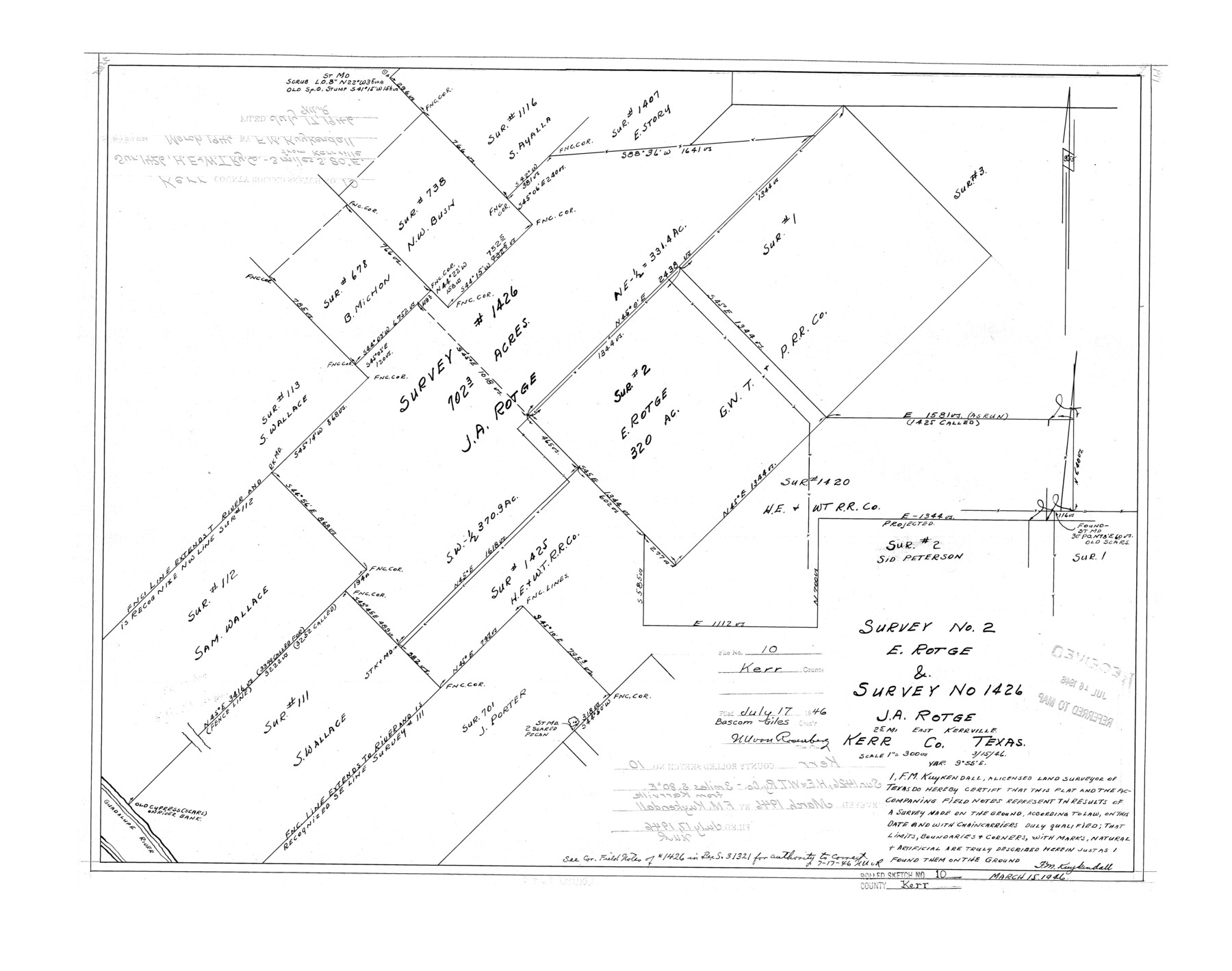
Kerr County Rolled Sketch 10
Survey no. 2, E. Rotge & survey no. 1426, J.A. Rotge
-
Map/Doc
6494
-
Collection
General Map Collection
-
Object Dates
1946/3/15 (Creation Date)
1946/7/17 (File Date)
-
People and Organizations
F.M. Kuykendall (Surveyor/Engineer)
-
Counties
Kerr
-
Subjects
Surveying Rolled Sketch
-
Height x Width
20.7 x 26.2 inches
52.6 x 66.5 cm
-
Scale
1" = 300 varas
Part of: General Map Collection
Runnels County Working Sketch 32

Print $20.00
- Digital $50.00
Runnels County Working Sketch 32
1959
Size 27.7 x 24.0 inches
Map/Doc 63630
Kenedy County Rolled Sketch 16

Print $40.00
- Digital $50.00
Kenedy County Rolled Sketch 16
1978
Size 36.7 x 50.2 inches
Map/Doc 10693
Location of the Southern Kansas Railway of Texas, Roberts County, Texas

Print $40.00
- Digital $50.00
Location of the Southern Kansas Railway of Texas, Roberts County, Texas
1887
Size 20.0 x 75.1 inches
Map/Doc 64037
Dawson County Sketch File 30

Print $40.00
- Digital $50.00
Dawson County Sketch File 30
1913
Size 13.6 x 9.1 inches
Map/Doc 20594
Terrell County Rolled Sketch 30

Print $40.00
- Digital $50.00
Terrell County Rolled Sketch 30
1931
Size 38.9 x 49.0 inches
Map/Doc 10735
Medina County

Print $40.00
- Digital $50.00
Medina County
1915
Size 53.2 x 44.8 inches
Map/Doc 10790
Carson County Sketch File 1

Print $20.00
- Digital $50.00
Carson County Sketch File 1
Size 16.8 x 18.5 inches
Map/Doc 11053
La Salle County Rolled Sketch 11

Print $20.00
- Digital $50.00
La Salle County Rolled Sketch 11
1947
Size 22.1 x 35.8 inches
Map/Doc 6574
Liberty County Working Sketch 53

Print $20.00
- Digital $50.00
Liberty County Working Sketch 53
1959
Size 31.1 x 34.4 inches
Map/Doc 70513
Tyler County Working Sketch 11

Print $20.00
- Digital $50.00
Tyler County Working Sketch 11
1941
Size 23.0 x 17.3 inches
Map/Doc 69481
Fort Bend County State Real Property Sketch 2

Print $40.00
- Digital $50.00
Fort Bend County State Real Property Sketch 2
1986
Size 34.8 x 43.4 inches
Map/Doc 61676
Ellis County Working Sketch 1

Print $20.00
- Digital $50.00
Ellis County Working Sketch 1
1939
Size 19.1 x 19.3 inches
Map/Doc 69017
You may also like
[S.E. corner of Sec. 48, Blk. 35 T5N to N.E. corner of Sec. 1, Blk. 35 T5N]
![89826, [S.E. corner of Sec. 48, Blk. 35 T5N to N.E. corner of Sec. 1, Blk. 35 T5N], Twichell Survey Records](https://historictexasmaps.com/wmedia_w700/maps/89826-1.tif.jpg)
Print $40.00
- Digital $50.00
[S.E. corner of Sec. 48, Blk. 35 T5N to N.E. corner of Sec. 1, Blk. 35 T5N]
1907
Size 7.2 x 72.9 inches
Map/Doc 89826

Flight Mission No. DIX-5P, Frame 106, Aransas County

Print $20.00
- Digital $50.00
Flight Mission No. DIX-5P, Frame 106, Aransas County
1956
Size 17.8 x 18.0 inches
Map/Doc 83784
Map of the River Sabine from its mouth on the Gulf of Mexico in the Sea to Logan's Ferry in Latitude 31°58'24" North

Print $40.00
- Digital $50.00
Map of the River Sabine from its mouth on the Gulf of Mexico in the Sea to Logan's Ferry in Latitude 31°58'24" North
1842
Size 67.6 x 30.6 inches
Map/Doc 87152
Nacogdoches County Sketch File 15

Print $10.00
- Digital $50.00
Nacogdoches County Sketch File 15
1926
Size 11.2 x 8.7 inches
Map/Doc 32262
Controlled Mosaic by Jack Amman Photogrammetric Engineers, Inc - Sheet 40

Print $20.00
- Digital $50.00
Controlled Mosaic by Jack Amman Photogrammetric Engineers, Inc - Sheet 40
1954
Size 20.0 x 24.0 inches
Map/Doc 83495
Sutton County Sketch File 3

Print $8.00
- Digital $50.00
Sutton County Sketch File 3
Size 12.9 x 8.5 inches
Map/Doc 37353
Map of The Surveyed Part of Peters Colony Texas

Print $40.00
- Digital $50.00
Map of The Surveyed Part of Peters Colony Texas
1852
Size 54.6 x 34.6 inches
Map/Doc 4654
Travis County Rolled Sketch 59

Print $20.00
- Digital $50.00
Travis County Rolled Sketch 59
1987
Size 17.0 x 22.6 inches
Map/Doc 8050
Hutchinson County Working Sketch 2

Print $20.00
- Digital $50.00
Hutchinson County Working Sketch 2
Size 32.0 x 18.9 inches
Map/Doc 66360
Slaton-Tex Water System

Print $20.00
- Digital $50.00
Slaton-Tex Water System
1922
Size 47.7 x 37.6 inches
Map/Doc 92818
Red River, Bois D'Arc Creek Floodway Sheet No. 7

Print $20.00
- Digital $50.00
Red River, Bois D'Arc Creek Floodway Sheet No. 7
1917
Size 29.0 x 23.8 inches
Map/Doc 69662