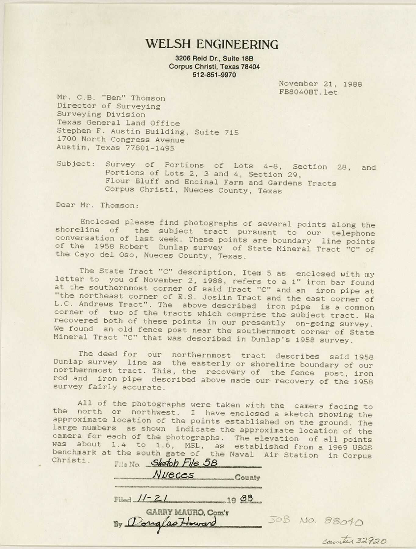
Nueces County Sketch File 58
Flour Bluff and Encinal Farm and Garden Tracts, Nueces County, Texas
-
Map/Doc
32920
-
Collection
General Map Collection
-
Object Dates
12/31/1981 (Creation Date)
11/1988 (Creation Date)
11/3/1988 (File Date)
11/21/1988
11/2/1988 (Correspondence Date)
10/1858 (Survey Date)
1/12/1989 (Correspondence Date)
12/30/1988 (Correspondence Date)
12/29/1988 (Correspondence Date)
1/18/1989 (Correspondence Date)
12/16/1988 (Correspondence Date)
12/29/1988 (Creation Date)
10/1958 (Survey Date)
-
People and Organizations
Nixon M. Welsh (Surveyor/Engineer)
William W. Green (Surveyor/Engineer)
Richard Lemley (Chainman/Field Personnel)
Fernado [sic] Trevino (Chainman/Field Personnel)
John Urtiago (Chainman/Field Personnel)
Robert M. Dunlap (Surveyor/Engineer)
George M. Pyle (Surveyor/Engineer)
K.G. Davis (Draftsman)
-
Counties
Nueces
-
Subjects
Surveying Sketch File
-
Height x Width
11.2 x 8.5 inches
28.5 x 21.6 cm
-
Medium
multi-page, multi-format
-
Features
Argonne Street
Sundeen Jr. High School
South Padre Island Drive
Hana Jr. High School
Oso Park
Smith School
Holly Road
U.S. Naval Radio Facility
Saratoga Boulevard
U.S. Government Railroad
Peary Place
Encinal Farm
McArdle Road
Porter Street
Wallace Street
Woodlawn School
Barnhart Street
Decatur Street
Baylark Street
Sea Lane Drive
South Bay Drive
Harbor Village
Sea Breeze
Anchor Harbor
Sahara Crive
Alameda Drive
Del Oso Road
Pharoa Crive
Pelican Bay Estates
Ocean Drive
Corpus Christi
Cayo del Oso
South Padre Island Drive
Ennis Joslin Road
Oso Creek
Laguna Madre
Cayo del Oso
Oso Bay
Blind Oso
Edgewater Terrace
University of Corpus Christi
Guth Park
Oso Municipal Golf Course
Flour Bluff
Corpus Christi Bay
Lexington Boulevard
University Heights
Ward Island
Koolside Park
South Alameda [Road]
Montclair School
Glenmore Street
Kenthner Street
Paloma Street
Cullen Place Jr. High School
Airline Road
Cullen Park
Part of: General Map Collection
Parker County Working Sketch 2

Print $20.00
- Digital $50.00
Parker County Working Sketch 2
1920
Map/Doc 71452
Kimble County Rolled Sketch 44

Print $20.00
- Digital $50.00
Kimble County Rolled Sketch 44
Size 35.9 x 24.2 inches
Map/Doc 96810
Right of Way and Track Map, the Missouri, Kansas & Texas Ry. Of Texas operated by the Missouri, Kansas & Texas Ry. Of Texas, Houston Division

Print $40.00
- Digital $50.00
Right of Way and Track Map, the Missouri, Kansas & Texas Ry. Of Texas operated by the Missouri, Kansas & Texas Ry. Of Texas, Houston Division
1918
Size 25.6 x 64.4 inches
Map/Doc 64566
Henderson County Sketch File 4

Print $4.00
- Digital $50.00
Henderson County Sketch File 4
1851
Size 12.9 x 8.3 inches
Map/Doc 26323
Fannin County Boundary File 4

Print $10.00
- Digital $50.00
Fannin County Boundary File 4
Size 8.5 x 8.6 inches
Map/Doc 53304
Ellis County Sketch File 18

Print $40.00
- Digital $50.00
Ellis County Sketch File 18
Size 16.0 x 12.8 inches
Map/Doc 21862
Hardin County Rolled Sketch 17

Print $20.00
- Digital $50.00
Hardin County Rolled Sketch 17
1951
Size 38.3 x 32.4 inches
Map/Doc 6087
Travis County Working Sketch 47

Print $40.00
- Digital $50.00
Travis County Working Sketch 47
1981
Size 55.5 x 41.8 inches
Map/Doc 69431
Fayette County

Print $40.00
- Digital $50.00
Fayette County
1920
Size 42.7 x 49.8 inches
Map/Doc 4945
Armstrong County Working Sketch 6

Print $20.00
- Digital $50.00
Armstrong County Working Sketch 6
1929
Size 24.3 x 19.4 inches
Map/Doc 67237
Flight Mission No. DAG-17K, Frame 139, Matagorda County

Print $20.00
- Digital $50.00
Flight Mission No. DAG-17K, Frame 139, Matagorda County
1952
Size 18.5 x 22.3 inches
Map/Doc 86356
Parker County Sketch File 9

Print $4.00
- Digital $50.00
Parker County Sketch File 9
Size 8.1 x 10.0 inches
Map/Doc 33538
You may also like
San Patricio County Sketch File 15A

Print $4.00
San Patricio County Sketch File 15A
1883
Size 11.0 x 8.5 inches
Map/Doc 97195
Atascosa County Sketch File 38

Print $40.00
- Digital $50.00
Atascosa County Sketch File 38
Size 16.3 x 23.8 inches
Map/Doc 10868
Tyler County Rolled Sketch 10

Print $40.00
- Digital $50.00
Tyler County Rolled Sketch 10
1982
Size 48.7 x 35.4 inches
Map/Doc 10032
Newton County Working Sketch 39

Print $20.00
- Digital $50.00
Newton County Working Sketch 39
1961
Size 36.6 x 41.0 inches
Map/Doc 71285
Houston County State Real Property Sketch 1

Print $20.00
- Digital $50.00
Houston County State Real Property Sketch 1
1997
Size 35.5 x 24.4 inches
Map/Doc 80129
King County Working Sketch 16

Print $40.00
- Digital $50.00
King County Working Sketch 16
1979
Size 41.4 x 59.4 inches
Map/Doc 70180
Archer County Sketch File 27

Print $40.00
- Digital $50.00
Archer County Sketch File 27
Size 19.1 x 21.1 inches
Map/Doc 10833
Trinity County Sketch File 2

Print $36.00
- Digital $50.00
Trinity County Sketch File 2
1855
Size 10.3 x 8.2 inches
Map/Doc 38490
Map of Dallas & Greenville Railroad through Dallas County, Texas

Print $2.00
- Digital $50.00
Map of Dallas & Greenville Railroad through Dallas County, Texas
Size 14.8 x 4.5 inches
Map/Doc 64487

Northeast Part Presidio County

Print $20.00
- Digital $50.00
Northeast Part Presidio County
1973
Size 42.3 x 33.4 inches
Map/Doc 95616
Dickens County Sketch File H

Print $28.00
- Digital $50.00
Dickens County Sketch File H
Size 13.2 x 8.9 inches
Map/Doc 20861