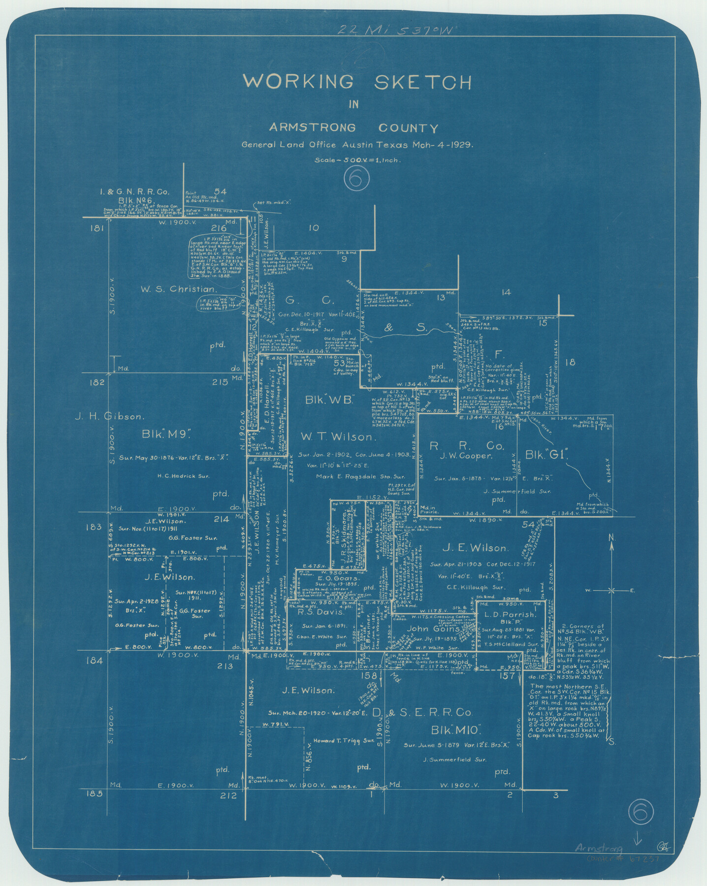
Armstrong County Working Sketch 6
-
Map/Doc
67237
-
Collection
General Map Collection
-
Object Dates
3/4/1929 (Creation Date)
-
Counties
Armstrong
-
Subjects
Surveying Working Sketch
-
Height x Width
24.3 x 19.4 inches
61.7 x 49.3 cm
-
Scale
1" = 500 varas
-
Comments
Surveys located about 22 miles South 37 degrees West of Claude, Texas.
Part of: General Map Collection
Cass County Sketch File 25

Print $14.00
- Digital $50.00
Cass County Sketch File 25
1936
Size 14.3 x 8.9 inches
Map/Doc 17444
Brewster County Rolled Sketch 75

Print $20.00
- Digital $50.00
Brewster County Rolled Sketch 75
1941
Size 31.5 x 36.9 inches
Map/Doc 8492
Flight Mission No. CRC-3R, Frame 22, Chambers County

Print $20.00
- Digital $50.00
Flight Mission No. CRC-3R, Frame 22, Chambers County
1956
Size 18.6 x 22.3 inches
Map/Doc 84796
Intracoastal Waterway in Texas - Corpus Christi to Point Isabel including Arroyo Colorado to Mo. Pac. R.R. Bridge Near Harlingen

Print $20.00
- Digital $50.00
Intracoastal Waterway in Texas - Corpus Christi to Point Isabel including Arroyo Colorado to Mo. Pac. R.R. Bridge Near Harlingen
1933
Size 28.0 x 40.7 inches
Map/Doc 61848
Flight Mission No. DAG-22K, Frame 74, Matagorda County

Print $20.00
- Digital $50.00
Flight Mission No. DAG-22K, Frame 74, Matagorda County
1953
Size 18.8 x 22.5 inches
Map/Doc 86461
Flight Mission No. DAG-23K, Frame 61, Matagorda County

Print $20.00
- Digital $50.00
Flight Mission No. DAG-23K, Frame 61, Matagorda County
1953
Size 16.0 x 15.7 inches
Map/Doc 86488
Outer Continental Shelf Leasing Maps (Texas Offshore Operations)

Print $20.00
- Digital $50.00
Outer Continental Shelf Leasing Maps (Texas Offshore Operations)
1954
Size 11.6 x 12.3 inches
Map/Doc 75835
Medina County Sketch File 15

Print $6.00
- Digital $50.00
Medina County Sketch File 15
1943
Size 14.2 x 8.5 inches
Map/Doc 31473
Burleson County Working Sketch 11

Print $20.00
- Digital $50.00
Burleson County Working Sketch 11
1980
Size 18.7 x 17.0 inches
Map/Doc 67730
Harris County Rolled Sketch WHW2

Print $20.00
- Digital $50.00
Harris County Rolled Sketch WHW2
Size 15.5 x 14.4 inches
Map/Doc 6148
Upton County Working Sketch 27

Print $20.00
- Digital $50.00
Upton County Working Sketch 27
1954
Size 24.2 x 33.9 inches
Map/Doc 69523
Flight Mission No. DAH-9M, Frame 162, Orange County

Print $20.00
- Digital $50.00
Flight Mission No. DAH-9M, Frame 162, Orange County
1953
Size 18.6 x 22.3 inches
Map/Doc 86861
You may also like
Briscoe County Working Sketch 7

Print $20.00
- Digital $50.00
Briscoe County Working Sketch 7
1944
Size 18.5 x 20.4 inches
Map/Doc 67810
Leon County Working Sketch 29

Print $20.00
- Digital $50.00
Leon County Working Sketch 29
1971
Size 25.8 x 33.1 inches
Map/Doc 70428
Schleicher County Sketch File 36

Print $20.00
- Digital $50.00
Schleicher County Sketch File 36
1951
Size 15.2 x 21.7 inches
Map/Doc 12309
Gulf Intracoastal Waterway - Aransas Bay to Corpus Christi Bay - Modified Route Main Channel

Print $20.00
- Digital $50.00
Gulf Intracoastal Waterway - Aransas Bay to Corpus Christi Bay - Modified Route Main Channel
Size 30.9 x 41.9 inches
Map/Doc 61904
Newton County Sketch File 22

Print $4.00
- Digital $50.00
Newton County Sketch File 22
1890
Size 14.2 x 8.7 inches
Map/Doc 32401
[Meander of Yellow House Creek from Northeast Corner of Section 37, Block S to Northeast corner of Section 3, Block O]
![91387, [Meander of Yellow House Creek from Northeast Corner of Section 37, Block S to Northeast corner of Section 3, Block O], Twichell Survey Records](https://historictexasmaps.com/wmedia_w700/maps/91387-1.tif.jpg)
Print $20.00
- Digital $50.00
[Meander of Yellow House Creek from Northeast Corner of Section 37, Block S to Northeast corner of Section 3, Block O]
Size 24.8 x 32.7 inches
Map/Doc 91387
Edwards County Working Sketch 71

Print $20.00
- Digital $50.00
Edwards County Working Sketch 71
1957
Size 17.4 x 23.8 inches
Map/Doc 68947
Packery Channel

Print $20.00
- Digital $50.00
Packery Channel
1950
Size 17.6 x 17.5 inches
Map/Doc 2997
Blanco County Working Sketch 33

Print $40.00
- Digital $50.00
Blanco County Working Sketch 33
1978
Size 41.0 x 57.5 inches
Map/Doc 67393
Flight Mission No. CLL-3N, Frame 45, Willacy County

Print $20.00
- Digital $50.00
Flight Mission No. CLL-3N, Frame 45, Willacy County
1954
Size 18.4 x 22.1 inches
Map/Doc 87103
Coryell County Sketch File 16

Print $4.00
- Digital $50.00
Coryell County Sketch File 16
Size 6.5 x 5.4 inches
Map/Doc 19373
Madison County Working Sketch Graphic Index

Print $20.00
- Digital $50.00
Madison County Working Sketch Graphic Index
1922
Size 29.4 x 47.6 inches
Map/Doc 76628