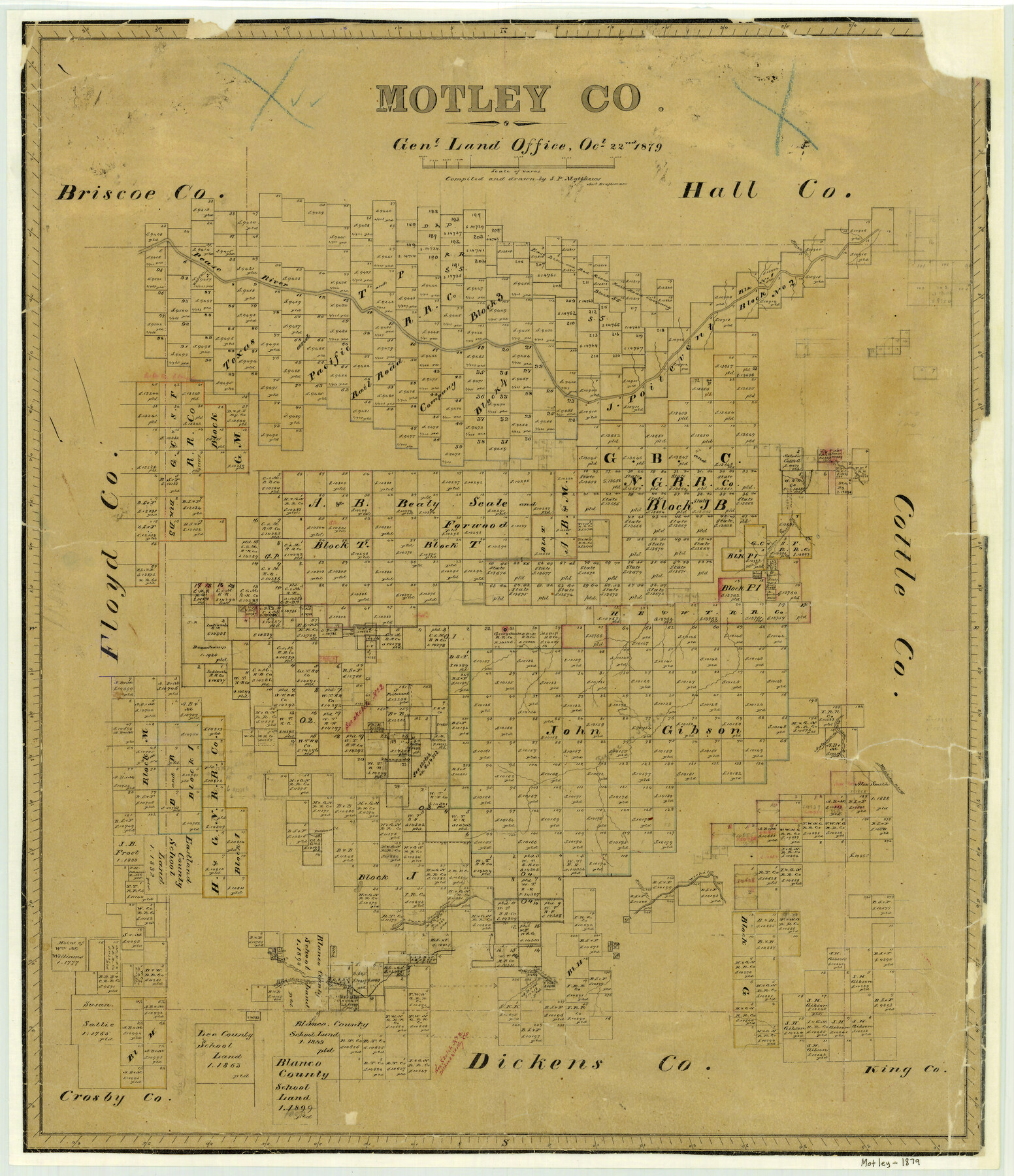
Motley County
-
Map/Doc
3904
-
Collection
General Map Collection
-
Object Dates
1879/10/22 (Creation Date)
-
People and Organizations
Texas General Land Office (Publisher)
Sam. P. Matthews (Compiler)
Sam. P. Matthews (Draftsman)
-
Counties
Motley
-
Subjects
County
-
Height x Width
24.4 x 21.0 inches
62.0 x 53.3 cm
-
Features
Jackson's Branch [of Wichita River]
T&P
China Creek
Salt Creek
Rusk Branch of Pease River
Warren Creek
Dan Coe Creek
South Fork of Middle Wichita River
Sallie Haynes Creek
South Fork of Pease River
Pease River
Bill's Branch [of Wichita River]
Dutchman Creek
Autumn Creek
Wichita River
Sadosa Creek
Middle Pease River
Bush Branch [of Middle Pease River]
Silver Creek
Part of: General Map Collection
El Paso County

Print $40.00
- Digital $50.00
El Paso County
1881
Size 53.7 x 88.3 inches
Map/Doc 16826
Blanco County Sketch File 12

Print $20.00
- Digital $50.00
Blanco County Sketch File 12
Size 15.0 x 19.8 inches
Map/Doc 10928
Zavala County Working Sketch Graphic Index

Print $20.00
- Digital $50.00
Zavala County Working Sketch Graphic Index
1977
Size 42.2 x 48.2 inches
Map/Doc 76751
That part of the boundary between the Republic of Texas and the United States, North of Sabine River from the 36th to the 72nd Mile Mound on the Meridian Line (Sheet No. 2)

Print $20.00
- Digital $50.00
That part of the boundary between the Republic of Texas and the United States, North of Sabine River from the 36th to the 72nd Mile Mound on the Meridian Line (Sheet No. 2)
1842
Size 33.7 x 26.0 inches
Map/Doc 3132
Potter County Working Sketch 5

Print $20.00
- Digital $50.00
Potter County Working Sketch 5
1920
Size 41.3 x 37.1 inches
Map/Doc 71665
Runnels County Sketch File 5a

Print $40.00
Runnels County Sketch File 5a
1883
Size 8.9 x 22.0 inches
Map/Doc 35438
Chambers County Sketch File X

Print $4.00
- Digital $50.00
Chambers County Sketch File X
1936
Size 11.1 x 8.7 inches
Map/Doc 17598
Texas Intracoastal Waterway, Aransas Bay to Aransas Pass

Print $20.00
- Digital $50.00
Texas Intracoastal Waterway, Aransas Bay to Aransas Pass
1962
Size 38.7 x 26.8 inches
Map/Doc 73439
Right of Way and Track Map, International & Gt. Northern Ry. Operated by the International & Gt. Northern Ry. Co., Gulf Division

Print $40.00
- Digital $50.00
Right of Way and Track Map, International & Gt. Northern Ry. Operated by the International & Gt. Northern Ry. Co., Gulf Division
1917
Size 25.0 x 56.6 inches
Map/Doc 64249
El Paso County Working Sketch 49

Print $20.00
- Digital $50.00
El Paso County Working Sketch 49
1990
Size 36.8 x 23.1 inches
Map/Doc 69071
Gaines County Working Sketch 33

Print $40.00
- Digital $50.00
Gaines County Working Sketch 33
1990
Size 50.3 x 36.0 inches
Map/Doc 69333
Webb County Sketch File 14c

Print $20.00
- Digital $50.00
Webb County Sketch File 14c
1892
Size 20.5 x 13.0 inches
Map/Doc 12633
You may also like
Map Showing Eastern Portion of Pecos County, Texas

Print $40.00
- Digital $50.00
Map Showing Eastern Portion of Pecos County, Texas
Size 62.2 x 43.5 inches
Map/Doc 89835
Dickens County Sketch File 18a

Print $20.00
- Digital $50.00
Dickens County Sketch File 18a
Size 17.6 x 19.4 inches
Map/Doc 11322
Alamo Defenders Heritage Map of Texas

Print $20.00
Alamo Defenders Heritage Map of Texas
2025
Size 36.0 x 24.0 inches
Map/Doc 97433
Ochiltree County Working Sketch 1

Print $20.00
- Digital $50.00
Ochiltree County Working Sketch 1
1954
Size 16.7 x 11.6 inches
Map/Doc 71314
Motley County Sketch File 6 (S)

Print $22.00
- Digital $50.00
Motley County Sketch File 6 (S)
Size 12.9 x 13.8 inches
Map/Doc 32145
Flight Mission No. BRA-9M, Frame 69, Jefferson County

Print $20.00
- Digital $50.00
Flight Mission No. BRA-9M, Frame 69, Jefferson County
1953
Size 18.5 x 22.3 inches
Map/Doc 85652
[Block M-23 and vicinity]
![91148, [Block M-23 and vicinity], Twichell Survey Records](https://historictexasmaps.com/wmedia_w700/maps/91148-1.tif.jpg)
Print $3.00
- Digital $50.00
[Block M-23 and vicinity]
Size 11.1 x 13.6 inches
Map/Doc 91148
Montgomery County Working Sketch 34

Print $20.00
- Digital $50.00
Montgomery County Working Sketch 34
1952
Size 43.0 x 35.8 inches
Map/Doc 71141
Reeves County Working Sketch 56

Print $40.00
- Digital $50.00
Reeves County Working Sketch 56
1978
Size 58.8 x 29.5 inches
Map/Doc 63499
San Jacinto County Rolled Sketch 6

Print $20.00
- Digital $50.00
San Jacinto County Rolled Sketch 6
Size 42.1 x 43.5 inches
Map/Doc 8361
Travis County Sketch File 77

Print $26.00
- Digital $50.00
Travis County Sketch File 77
2004
Size 11.0 x 8.5 inches
Map/Doc 83254
Sutton County Working Sketch 46

Print $40.00
- Digital $50.00
Sutton County Working Sketch 46
1953
Size 48.4 x 27.1 inches
Map/Doc 62389