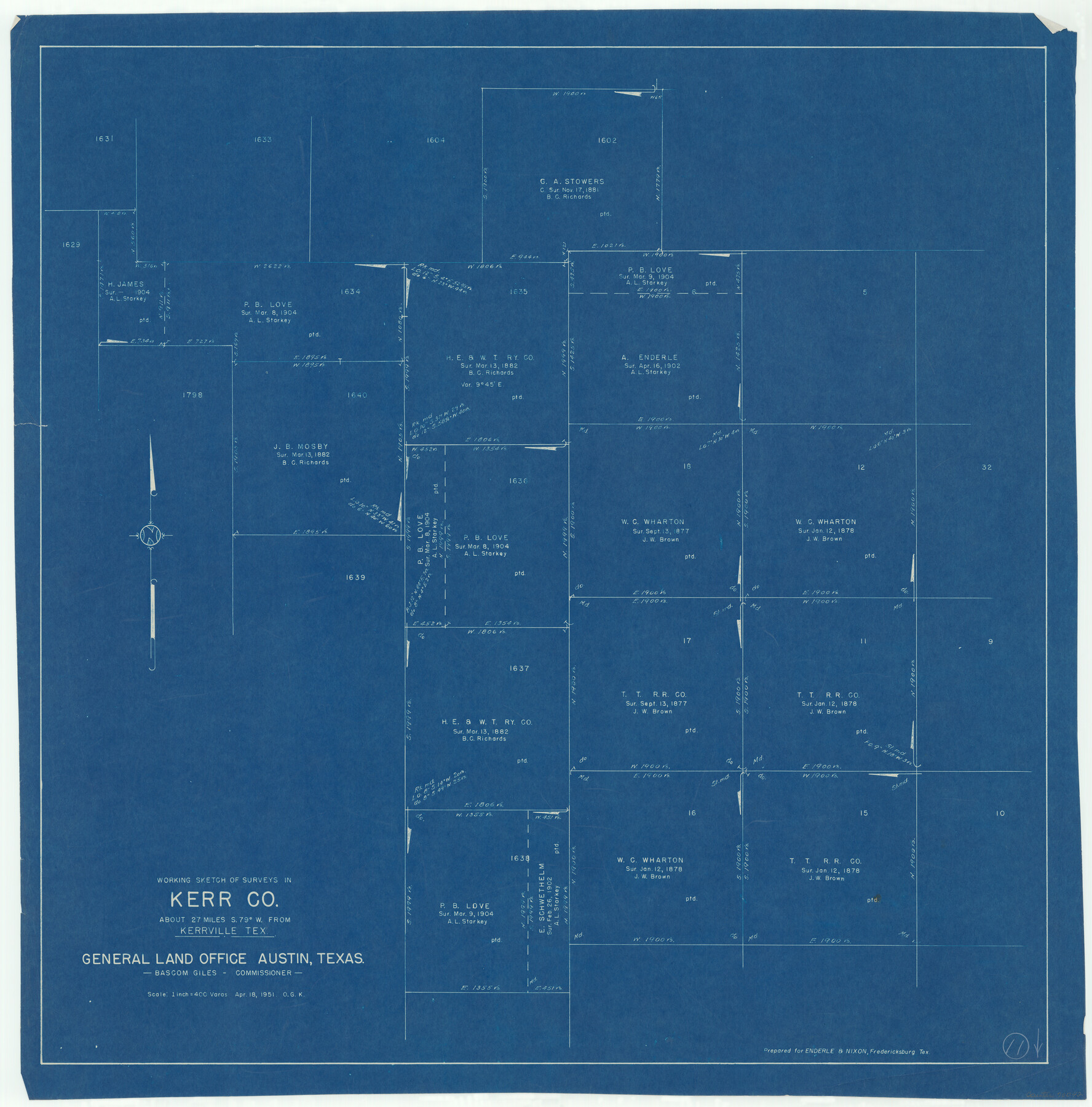
Kerr County Working Sketch 11
-
Map/Doc
70042
-
Collection
General Map Collection
-
Object Dates
4/18/1951 (Creation Date)
-
People and Organizations
Otto G. Kurio (Draftsman)
-
Counties
Kerr
-
Subjects
Surveying Working Sketch
-
Height x Width
30.3 x 29.9 inches
77.0 x 76.0 cm
-
Scale
1" = 400 varas
Part of: General Map Collection
Reeves County Sketch File 12

Print $20.00
- Digital $50.00
Reeves County Sketch File 12
Size 42.7 x 31.3 inches
Map/Doc 10588
Hardeman County Sketch File 8a

Print $20.00
- Digital $50.00
Hardeman County Sketch File 8a
Size 16.0 x 32.0 inches
Map/Doc 11623
Presidio County Working Sketch 128

Print $20.00
- Digital $50.00
Presidio County Working Sketch 128
1987
Size 37.3 x 29.0 inches
Map/Doc 71806
Flight Mission No. BQY-4M, Frame 62, Harris County

Print $20.00
- Digital $50.00
Flight Mission No. BQY-4M, Frame 62, Harris County
1953
Size 18.7 x 22.5 inches
Map/Doc 85271
Presidio County Working Sketch 33

Print $40.00
- Digital $50.00
Presidio County Working Sketch 33
1947
Size 41.6 x 50.6 inches
Map/Doc 71710
Leon County Working Sketch 2

Print $20.00
- Digital $50.00
Leon County Working Sketch 2
Size 17.3 x 17.0 inches
Map/Doc 70401
Texas Gulf Coast Map from the Sabine River to the Rio Grande as subdivided for mineral development

Print $20.00
- Digital $50.00
Texas Gulf Coast Map from the Sabine River to the Rio Grande as subdivided for mineral development
1948
Size 41.6 x 39.2 inches
Map/Doc 2904
Liberty County Sketch File 58

Print $2.00
- Digital $50.00
Liberty County Sketch File 58
Size 8.9 x 7.7 inches
Map/Doc 30060
Bailey County Sketch File 3

Print $22.00
- Digital $50.00
Bailey County Sketch File 3
1901
Size 8.9 x 6.8 inches
Map/Doc 13937
Frio County Rolled Sketch 5

Print $20.00
- Digital $50.00
Frio County Rolled Sketch 5
Size 25.7 x 23.0 inches
Map/Doc 5917
[Map showing resurvey of Capitol Leagues in Hartley & Dallam Counties, Texas]
![1753, [Map showing resurvey of Capitol Leagues in Hartley & Dallam Counties, Texas], General Map Collection](https://historictexasmaps.com/wmedia_w700/maps/1753-1.tif.jpg)
Print $40.00
- Digital $50.00
[Map showing resurvey of Capitol Leagues in Hartley & Dallam Counties, Texas]
1918
Size 66.9 x 31.0 inches
Map/Doc 1753
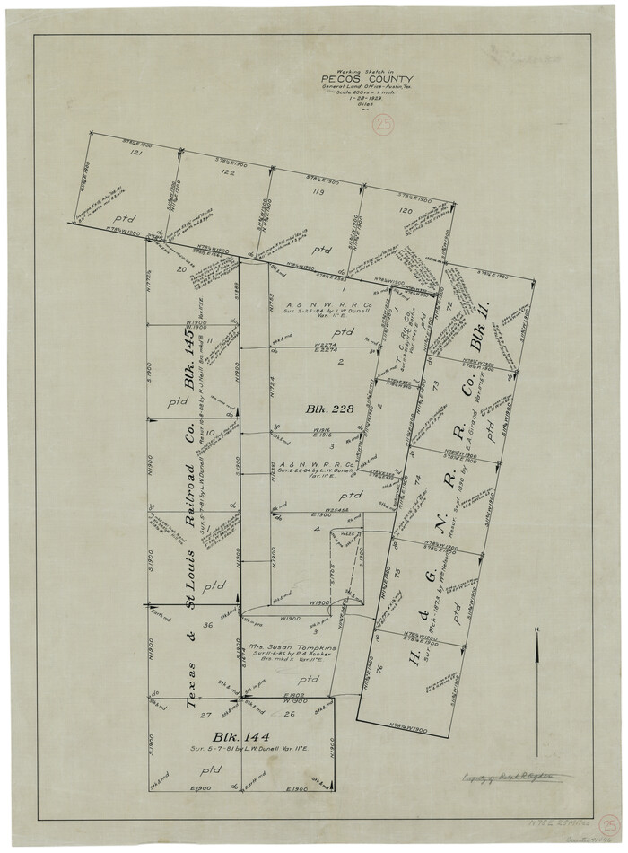
Pecos County Working Sketch 25
Print $20.00
- Digital $50.00
Pecos County Working Sketch 25
1929
Size 28.9 x 21.1 inches
Map/Doc 71496
You may also like
Right-of-Way and Track Map, Houston and Brazos Valley Ry. Co. operated by the Houston and Brazos Valley Ry. Co.

Print $40.00
- Digital $50.00
Right-of-Way and Track Map, Houston and Brazos Valley Ry. Co. operated by the Houston and Brazos Valley Ry. Co.
1918
Size 24.9 x 56.6 inches
Map/Doc 64606
Haskell County Working Sketch 1

Print $40.00
- Digital $50.00
Haskell County Working Sketch 1
Size 31.0 x 74.5 inches
Map/Doc 66059
Brazoria County Rolled Sketch 46

Print $40.00
- Digital $50.00
Brazoria County Rolled Sketch 46
1950
Size 30.7 x 57.3 inches
Map/Doc 8462
Matagorda County Rolled Sketch 23

Print $20.00
- Digital $50.00
Matagorda County Rolled Sketch 23
1942
Size 25.0 x 23.8 inches
Map/Doc 6690
[Sketch for Mineral Application 33721 - 33725 Incl. - Padre and Mustang Island]
![2869, [Sketch for Mineral Application 33721 - 33725 Incl. - Padre and Mustang Island], General Map Collection](https://historictexasmaps.com/wmedia_w700/maps/2869.tif.jpg)
Print $20.00
- Digital $50.00
[Sketch for Mineral Application 33721 - 33725 Incl. - Padre and Mustang Island]
1942
Size 22.2 x 22.3 inches
Map/Doc 2869
Briscoe County Working Sketch 6

Print $20.00
- Digital $50.00
Briscoe County Working Sketch 6
1940
Size 31.0 x 24.5 inches
Map/Doc 67809
Upton County Working Sketch 57

Print $20.00
- Digital $50.00
Upton County Working Sketch 57
1988
Size 28.9 x 37.4 inches
Map/Doc 69554
Aransas County Rolled Sketch 10

Print $58.00
- Digital $50.00
Aransas County Rolled Sketch 10
1936
Size 10.6 x 15.4 inches
Map/Doc 42208
Fayette County

Print $40.00
- Digital $50.00
Fayette County
1978
Size 42.5 x 54.7 inches
Map/Doc 73146
Hockley County Sketch File 5

Print $4.00
- Digital $50.00
Hockley County Sketch File 5
Size 9.1 x 11.2 inches
Map/Doc 26539
Coke County Working Sketch 8

Print $20.00
- Digital $50.00
Coke County Working Sketch 8
1926
Size 26.9 x 25.5 inches
Map/Doc 68045
Hunt County Rolled Sketch 5

Print $20.00
- Digital $50.00
Hunt County Rolled Sketch 5
1966
Size 24.6 x 24.2 inches
Map/Doc 6276