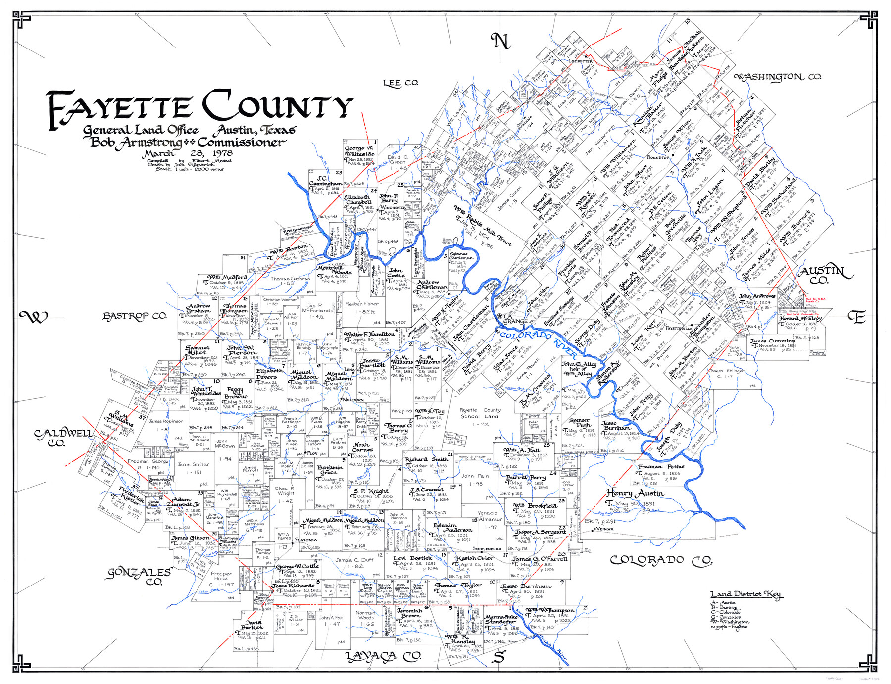
Fayette County
-
Map/Doc
73146
-
Collection
General Map Collection
-
Object Dates
3/28/1978 (Creation Date)
-
People and Organizations
Elbert Menzel (Compiler)
Bob Armstrong (GLO Commissioner)
Joan Kilpatrick (Draftsman)
-
Counties
Fayette
-
Subjects
County
-
Height x Width
42.5 x 54.7 inches
108.0 x 138.9 cm
-
Scale
1" = 2000 varas
-
Features
Peach Creek
South Fork of Buckner's Creek
Buckner's Creek
Lena
Muldoon
Burnham's Crossing
Harvey's Creek
Boggy Creek
Weimar
Schulenburg
GH&SA
Upper Rocky Creek
Sandy Fork of Mulberry Creek
Mulberry Creek
Flatonia
North Fork of Buckner's Creek
East Fork of Peach Creek
San Felipe Road
St. Barnabas Creek
Persimmon Creek
Fayetteville
William's Creek
Floy
Navidad River
Main Fork of Navidad River
Brushy Creek
East Navidad River
Gonzales Road
Wilbarger Trace
Williamson's Creek
Mesquite Creek
Pin Oak Creek
Little Pin Oak Creek
Ruiz Creek
Willow Creek
Rabb's Creek
David's Creek
Green's Creek
Owl Creek
Wilbarger Road
Washington Road
Bastrop Road
Washington to Bastrop Road
Cummins Creek
Pin Oak Fork of Buckner's Creek
Ledbetter
H&TC
Round Top
Rocky Creek
La Bahia Road
Cedar Creek
Miller's Creek
La Grange
Colorado River
SA&AP
Winchester
Westpoint
MK&T
Part of: General Map Collection
Burleson County Working Sketch 27

Print $20.00
- Digital $50.00
Burleson County Working Sketch 27
1981
Size 23.8 x 12.2 inches
Map/Doc 67746
Fort Bend County State Real Property Sketch 13

Print $40.00
- Digital $50.00
Fort Bend County State Real Property Sketch 13
1987
Size 36.3 x 47.9 inches
Map/Doc 61687
Johnson County Boundary File 51a

Print $66.00
- Digital $50.00
Johnson County Boundary File 51a
Size 12.7 x 8.2 inches
Map/Doc 55604
Yoakum County Rolled Sketch 3(2)

Print $40.00
- Digital $50.00
Yoakum County Rolled Sketch 3(2)
1959
Size 12.4 x 104.3 inches
Map/Doc 76041
Midland County Working Sketch 19

Print $20.00
- Digital $50.00
Midland County Working Sketch 19
1953
Size 29.9 x 24.7 inches
Map/Doc 70999
Upton County Sketch File 33

Print $20.00
- Digital $50.00
Upton County Sketch File 33
1939
Size 19.4 x 20.8 inches
Map/Doc 12524
Mills County Working Sketch 24

Print $20.00
- Digital $50.00
Mills County Working Sketch 24
1988
Size 40.3 x 36.5 inches
Map/Doc 71054
Louisiana and Texas Intracoastal Waterway - Dredging from Freeport Harbor to Caney Creek - Sheet 2

Print $20.00
- Digital $50.00
Louisiana and Texas Intracoastal Waterway - Dredging from Freeport Harbor to Caney Creek - Sheet 2
1940
Size 31.2 x 41.3 inches
Map/Doc 61817
Medina County Working Sketch 15

Print $20.00
- Digital $50.00
Medina County Working Sketch 15
1974
Size 26.2 x 18.7 inches
Map/Doc 70930
Webb County Working Sketch 58

Print $20.00
- Digital $50.00
Webb County Working Sketch 58
1958
Size 37.4 x 37.0 inches
Map/Doc 72424
Sutton County Working Sketch 68

Print $40.00
- Digital $50.00
Sutton County Working Sketch 68
1972
Size 61.2 x 37.4 inches
Map/Doc 62411
Brewster County Working Sketch 47

Print $20.00
- Digital $50.00
Brewster County Working Sketch 47
1949
Size 42.9 x 35.4 inches
Map/Doc 67581
You may also like
Chambers County Sketch File 17

Print $40.00
- Digital $50.00
Chambers County Sketch File 17
1878
Size 12.4 x 15.6 inches
Map/Doc 17567


Austin County, Texas

Print $20.00
- Digital $50.00
Austin County, Texas
1879
Size 23.5 x 28.8 inches
Map/Doc 689
Flight Mission No. BRE-2P, Frame 45, Nueces County

Print $20.00
- Digital $50.00
Flight Mission No. BRE-2P, Frame 45, Nueces County
1956
Size 18.6 x 22.6 inches
Map/Doc 86747
El Paso County Sketch File 35 (5)

Print $6.00
- Digital $50.00
El Paso County Sketch File 35 (5)
1886
Size 14.6 x 8.9 inches
Map/Doc 22218
Map of Cherokee Co.

Print $40.00
- Digital $50.00
Map of Cherokee Co.
1902
Size 49.6 x 39.7 inches
Map/Doc 4908
[H. & T. C. Block 47, East Line and Red River RR. Co. Block Z and vicinity]
![92974, [H. & T. C. Block 47, East Line and Red River RR. Co. Block Z and vicinity], Twichell Survey Records](https://historictexasmaps.com/wmedia_w700/maps/92974-1.tif.jpg)
Print $20.00
- Digital $50.00
[H. & T. C. Block 47, East Line and Red River RR. Co. Block Z and vicinity]
Size 17.4 x 14.0 inches
Map/Doc 92974
Haskell County Sketch File 22

Print $6.00
- Digital $50.00
Haskell County Sketch File 22
Size 14.3 x 8.8 inches
Map/Doc 26179
[Galveston, Harrisburg & San Antonio through El Paso County]
![64008, [Galveston, Harrisburg & San Antonio through El Paso County], General Map Collection](https://historictexasmaps.com/wmedia_w700/maps/64008.tif.jpg)
Print $20.00
- Digital $50.00
[Galveston, Harrisburg & San Antonio through El Paso County]
1906
Size 13.7 x 33.8 inches
Map/Doc 64008
Flight Mission No. BQY-4M, Frame 33, Harris County

Print $20.00
- Digital $50.00
Flight Mission No. BQY-4M, Frame 33, Harris County
1953
Size 18.7 x 22.4 inches
Map/Doc 85248
Gulf Coast of the United States, Key West to Rio Grande

Print $20.00
- Digital $50.00
Gulf Coast of the United States, Key West to Rio Grande
1863
Size 27.5 x 18.3 inches
Map/Doc 72664