Corpus Christi
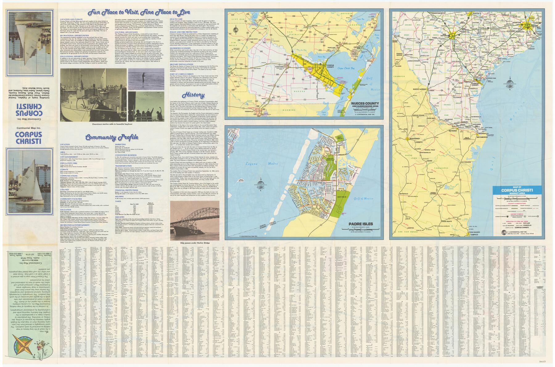
[Verso: Information about Corpus Christi and inset maps of Nueces County, Padre Isles, and Corpus Chrisiti Market Area]
-
Map/Doc
94427
-
Collection
General Map Collection
-
Object Dates
1977 (Copyright Date)
1986 (Edition Date)
-
People and Organizations
Continental Map Inc. (Publisher)
-
Counties
Nueces
-
Height x Width
25.4 x 38.5 inches
64.5 x 97.8 cm
-
Medium
paper, etching/engraving/lithograph
-
Comments
See 94426 for map of Corpus Christi on recto.
Related maps

Part of: General Map Collection
Coleman County Sketch File 24

Print $6.00
- Digital $50.00
Coleman County Sketch File 24
1872
Size 8.7 x 7.8 inches
Map/Doc 18705
Guadalupe County

Print $20.00
- Digital $50.00
Guadalupe County
1977
Size 35.0 x 45.9 inches
Map/Doc 77297
McMullen County Working Sketch 46

Print $20.00
- Digital $50.00
McMullen County Working Sketch 46
1982
Size 35.2 x 22.0 inches
Map/Doc 70747
Upton County Sketch File 11

Print $20.00
- Digital $50.00
Upton County Sketch File 11
1919
Size 22.5 x 27.6 inches
Map/Doc 12511
Flight Mission No. CGI-1N, Frame 214, Cameron County

Print $20.00
- Digital $50.00
Flight Mission No. CGI-1N, Frame 214, Cameron County
1955
Size 18.5 x 22.1 inches
Map/Doc 84523
A Compleat Map of the West Indies, containing the Coasts of Florida, Louisiana, New Spain, and Terra Firma: with all the Islands

Print $20.00
- Digital $50.00
A Compleat Map of the West Indies, containing the Coasts of Florida, Louisiana, New Spain, and Terra Firma: with all the Islands
1774
Size 13.9 x 19.0 inches
Map/Doc 97400
Hidalgo County Rolled Sketch 3

Print $20.00
- Digital $50.00
Hidalgo County Rolled Sketch 3
1881
Size 27.0 x 20.3 inches
Map/Doc 6206
Flight Mission No. DAG-24K, Frame 134, Matagorda County

Print $20.00
- Digital $50.00
Flight Mission No. DAG-24K, Frame 134, Matagorda County
1953
Size 17.1 x 15.6 inches
Map/Doc 86552
[Sketch for Mineral Application 24072, San Jacinto River]
![65605, [Sketch for Mineral Application 24072, San Jacinto River], General Map Collection](https://historictexasmaps.com/wmedia_w700/maps/65605.tif.jpg)
Print $20.00
- Digital $50.00
[Sketch for Mineral Application 24072, San Jacinto River]
1929
Size 23.4 x 17.8 inches
Map/Doc 65605
Palo Pinto County Sketch File 20

Print $6.00
- Digital $50.00
Palo Pinto County Sketch File 20
1891
Size 12.5 x 10.9 inches
Map/Doc 33402
Karnes County Working Sketch 11

Print $40.00
- Digital $50.00
Karnes County Working Sketch 11
1975
Size 38.1 x 53.6 inches
Map/Doc 66659
San Patricio County Rolled Sketch 55

Print $20.00
- Digital $50.00
San Patricio County Rolled Sketch 55
1999
Size 25.1 x 36.7 inches
Map/Doc 7741
You may also like
Shelby County Working Sketch Graphic Index

Print $20.00
- Digital $50.00
Shelby County Working Sketch Graphic Index
1945
Size 42.9 x 44.3 inches
Map/Doc 76697
Potter County Sketch File 9

Print $20.00
- Digital $50.00
Potter County Sketch File 9
1887
Size 12.5 x 17.7 inches
Map/Doc 12198
Bexar County Working Sketch 18

Print $20.00
- Digital $50.00
Bexar County Working Sketch 18
1979
Size 22.6 x 18.3 inches
Map/Doc 67334
Angelina County Sketch File 18a

Print $5.00
- Digital $50.00
Angelina County Sketch File 18a
Size 7.7 x 12.0 inches
Map/Doc 13030
Bosque County Working Sketch 16

Print $20.00
- Digital $50.00
Bosque County Working Sketch 16
1974
Size 40.5 x 33.2 inches
Map/Doc 67449
[Surveys in the Fannin District: Bois d'Arc Creek, Sulphur Creek]
![263, [Surveys in the Fannin District: Bois d'Arc Creek, Sulphur Creek], General Map Collection](https://historictexasmaps.com/wmedia_w700/maps/263.tif.jpg)
Print $2.00
- Digital $50.00
[Surveys in the Fannin District: Bois d'Arc Creek, Sulphur Creek]
1844
Size 7.9 x 7.9 inches
Map/Doc 263

Sketch Showing Block 142, Original Town, Survey 1, Block O

Print $20.00
- Digital $50.00
Sketch Showing Block 142, Original Town, Survey 1, Block O
Size 23.0 x 18.0 inches
Map/Doc 92782
Matagorda County Working Sketch 24

Print $20.00
- Digital $50.00
Matagorda County Working Sketch 24
1972
Size 25.3 x 34.5 inches
Map/Doc 70882
Travis County Rolled Sketch 23

Print $20.00
- Digital $50.00
Travis County Rolled Sketch 23
1941
Size 30.5 x 37.7 inches
Map/Doc 8024
Stonewall County Working Sketch 26

Print $20.00
- Digital $50.00
Stonewall County Working Sketch 26
1973
Size 27.0 x 17.9 inches
Map/Doc 62333
Wheeler County Working Sketch 16

Print $20.00
- Digital $50.00
Wheeler County Working Sketch 16
1982
Size 38.9 x 25.8 inches
Map/Doc 72505