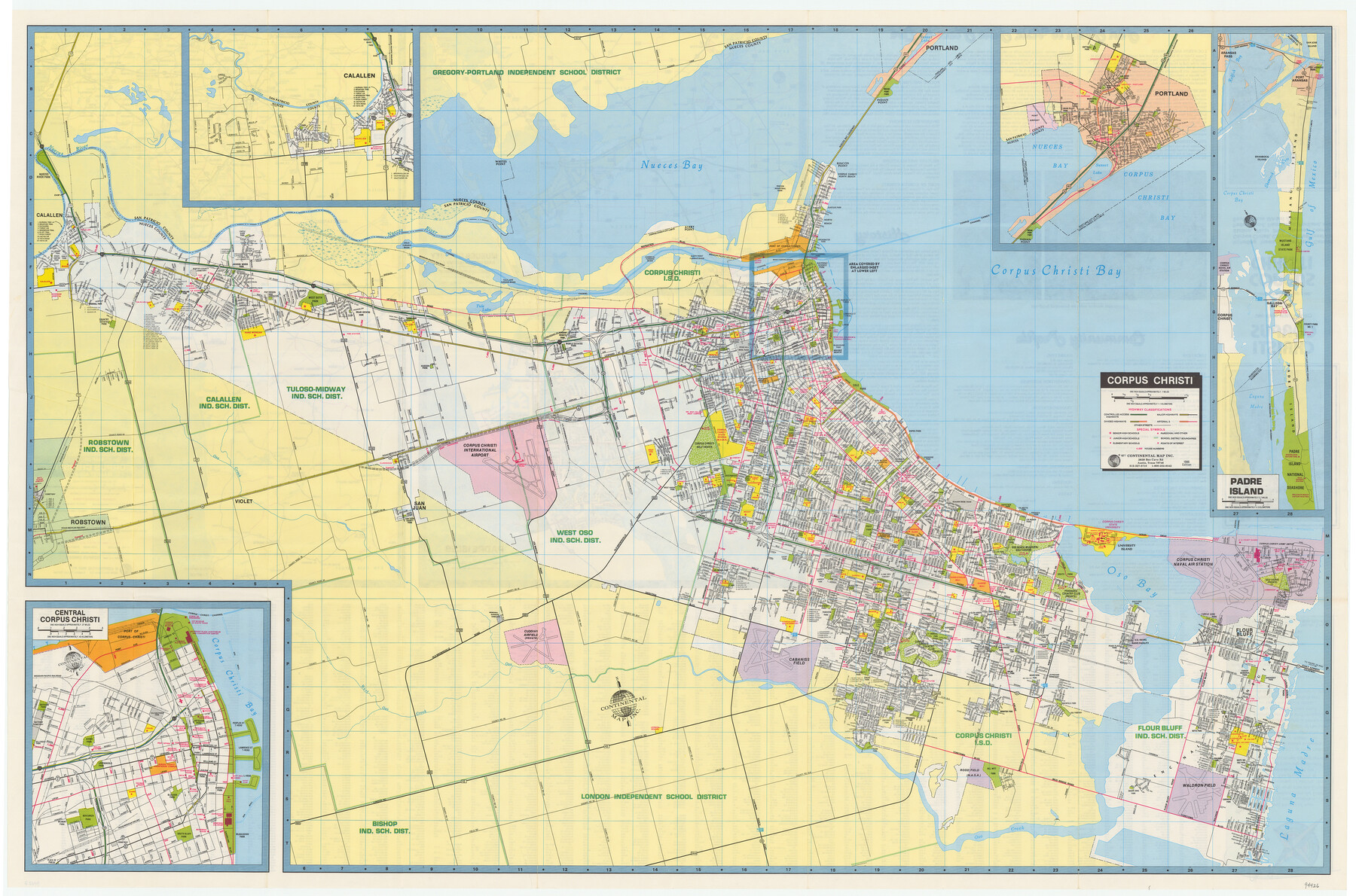
Corpus Christi
[Recto: Corpus Christi with inset maps of Calallen, Portland, Central Corpus Christi, and Padre Island]
-
Map/Doc
94426
-
Collection
General Map Collection
-
Object Dates
1977 (Copyright Date)
1986 (Edition Date)
-
People and Organizations
Continental Map Inc. (Publisher)
-
Counties
Nueces
-
Subjects
City
-
Height x Width
25.5 x 38.6 inches
64.8 x 98.0 cm
-
Medium
paper, etching/engraving/lithograph
-
Comments
See 94427 for information about Corpus Christi and inset maps of Nueces County, Padre Isles, and Corpus Christi Market Area on verso.
Related maps

Part of: General Map Collection
Travis County Rolled Sketch 30

Print $20.00
- Digital $50.00
Travis County Rolled Sketch 30
1943
Size 26.5 x 25.6 inches
Map/Doc 8032
Lee County Sketch File 4

Print $4.00
- Digital $50.00
Lee County Sketch File 4
1859
Size 9.5 x 8.1 inches
Map/Doc 29682
Denton County Working Sketch 1

Print $20.00
- Digital $50.00
Denton County Working Sketch 1
1920
Size 16.1 x 12.9 inches
Map/Doc 68606
Harris County Rolled Sketch 80B

Print $20.00
- Digital $50.00
Harris County Rolled Sketch 80B
Size 32.0 x 44.2 inches
Map/Doc 9137
[Galveston, Harrisburg & San Antonio Railway]
![64403, [Galveston, Harrisburg & San Antonio Railway], General Map Collection](https://historictexasmaps.com/wmedia_w700/maps/64403.tif.jpg)
Print $20.00
- Digital $50.00
[Galveston, Harrisburg & San Antonio Railway]
1892
Size 13.7 x 33.7 inches
Map/Doc 64403
Milam County Boundary File 5

Print $18.00
- Digital $50.00
Milam County Boundary File 5
Size 8.9 x 9.7 inches
Map/Doc 57223
Port Series No. 6 - The Ports of Galveston, Houston, and Texas City, Texas

Port Series No. 6 - The Ports of Galveston, Houston, and Texas City, Texas
1924
Map/Doc 97159
Presidio County Working Sketch 54

Print $20.00
- Digital $50.00
Presidio County Working Sketch 54
1955
Size 26.0 x 20.8 inches
Map/Doc 71731
Map of the Fort Worth & Denver City Railway, Wichita County, Texas

Print $40.00
- Digital $50.00
Map of the Fort Worth & Denver City Railway, Wichita County, Texas
1885
Size 23.7 x 66.5 inches
Map/Doc 64455
Post Route Map of the State of Texas with adjacent parts of Louisiana, Arkansas, Indian Territory, and of the Republic of Mexico showing post offices with the intermediate and mail routes in operation on the 1st of December, 1892

Print $40.00
- Digital $50.00
Post Route Map of the State of Texas with adjacent parts of Louisiana, Arkansas, Indian Territory, and of the Republic of Mexico showing post offices with the intermediate and mail routes in operation on the 1st of December, 1892
1889
Size 44.0 x 57.3 inches
Map/Doc 94080
Recharge zone of the Edwards Aquifer hydrologically associated with Barton Springs in the Austin Area, Texas

Print $20.00
- Digital $50.00
Recharge zone of the Edwards Aquifer hydrologically associated with Barton Springs in the Austin Area, Texas
1986
Size 41.5 x 29.3 inches
Map/Doc 60400
[Maps of surveys in Reeves & Culberson Cos]
![61129, [Maps of surveys in Reeves & Culberson Cos], General Map Collection](https://historictexasmaps.com/wmedia_w700/maps/61129.tif.jpg)
Print $20.00
- Digital $50.00
[Maps of surveys in Reeves & Culberson Cos]
1937
Size 30.7 x 25.0 inches
Map/Doc 61129
You may also like
Map of the country adjacent to the left bank of the Rio Grande below Matamoros

Print $20.00
- Digital $50.00
Map of the country adjacent to the left bank of the Rio Grande below Matamoros
1847
Size 18.4 x 27.4 inches
Map/Doc 72869
El Paso County Working Sketch 47

Print $20.00
- Digital $50.00
El Paso County Working Sketch 47
Size 28.3 x 30.5 inches
Map/Doc 69069
Map illustrating the general geological features of the country west of the Mississippi River compiled from the surveys of W.H. Emory and from the Pacific Railroad surveys & other sources

Print $20.00
- Digital $50.00
Map illustrating the general geological features of the country west of the Mississippi River compiled from the surveys of W.H. Emory and from the Pacific Railroad surveys & other sources
1857
Size 21.2 x 24.7 inches
Map/Doc 95172
Leon County Working Sketch 4

Print $20.00
- Digital $50.00
Leon County Working Sketch 4
Size 18.1 x 14.0 inches
Map/Doc 70403
Montgomery County Sketch File 37

Print $6.00
- Digital $50.00
Montgomery County Sketch File 37
Size 12.6 x 8.2 inches
Map/Doc 31916
Sterling County Sketch File 17a

Print $20.00
- Digital $50.00
Sterling County Sketch File 17a
Size 42.8 x 31.6 inches
Map/Doc 10609
Galveston County Aerial Photograph Index Sheet 2

Print $20.00
- Digital $50.00
Galveston County Aerial Photograph Index Sheet 2
1953
Size 21.2 x 19.5 inches
Map/Doc 83693
Milam County Boundary File 65

Print $10.00
- Digital $50.00
Milam County Boundary File 65
Size 8.8 x 7.8 inches
Map/Doc 57251
[Plat map showing mostly Overton Addition]
![92825, [Plat map showing mostly Overton Addition], Twichell Survey Records](https://historictexasmaps.com/wmedia_w700/maps/92825-1.tif.jpg)
Print $20.00
- Digital $50.00
[Plat map showing mostly Overton Addition]
Size 31.7 x 31.4 inches
Map/Doc 92825
Haskell County Sketch File 15

Print $24.00
- Digital $50.00
Haskell County Sketch File 15
1893
Size 13.5 x 16.5 inches
Map/Doc 26158

[King/Stonewall County Line]
![90979, [King/Stonewall County Line], Twichell Survey Records](https://historictexasmaps.com/wmedia_w700/maps/90979-1.tif.jpg)
Print $20.00
- Digital $50.00
[King/Stonewall County Line]
1895
Size 38.9 x 8.3 inches
Map/Doc 90979