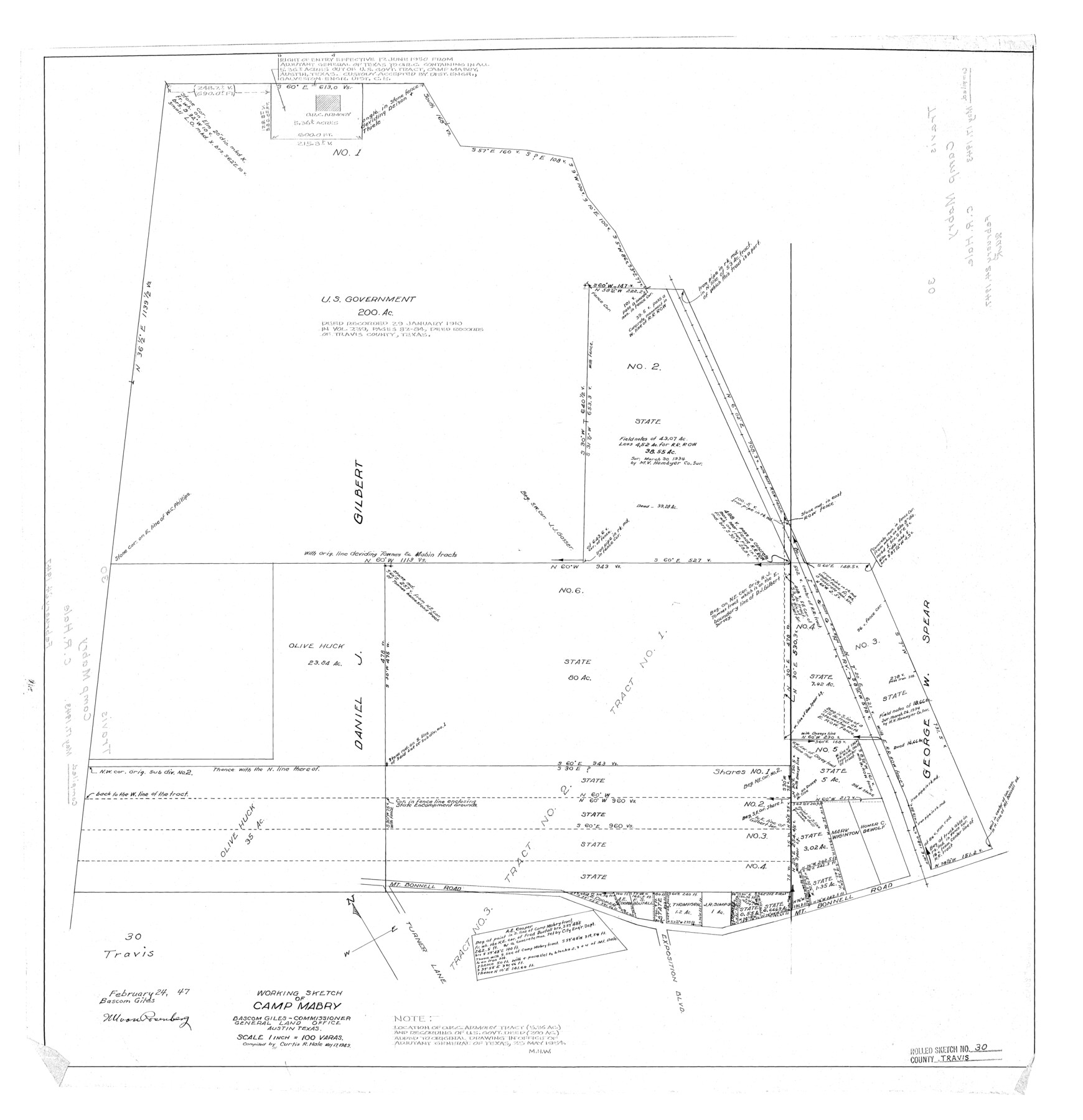
Travis County Rolled Sketch 30
Working Sketch of Camp Mabry
-
Map/Doc
8032
-
Collection
General Map Collection
-
Object Dates
1943/5/17 (Creation Date)
1947/2/24 (File Date)
-
People and Organizations
Curtis R. Hale (Compiler)
-
Counties
Travis
-
Subjects
Surveying Rolled Sketch
-
Height x Width
26.5 x 25.6 inches
67.3 x 65.0 cm
-
Scale
1" = 100 varas
Part of: General Map Collection
Carta Historica y Arqueologica

Print $20.00
- Digital $50.00
Carta Historica y Arqueologica
Size 26.0 x 34.4 inches
Map/Doc 96806
Map of Harris County

Print $40.00
- Digital $50.00
Map of Harris County
1896
Size 50.0 x 68.7 inches
Map/Doc 4675
A How to Get From Here to There Map and Water Too of Metropolitan Houston

A How to Get From Here to There Map and Water Too of Metropolitan Houston
Size 36.6 x 25.5 inches
Map/Doc 94361
Crockett County Sketch File 21

Print $18.00
- Digital $50.00
Crockett County Sketch File 21
Size 13.6 x 8.4 inches
Map/Doc 19682
Brazos County Working Sketch 10

Print $20.00
- Digital $50.00
Brazos County Working Sketch 10
1991
Size 15.8 x 20.7 inches
Map/Doc 67485
Karnes County Boundary File 5a

Print $4.00
- Digital $50.00
Karnes County Boundary File 5a
Size 8.1 x 13.3 inches
Map/Doc 55721
Flight Mission No. BRE-1P, Frame 5, Nueces County

Print $20.00
- Digital $50.00
Flight Mission No. BRE-1P, Frame 5, Nueces County
1956
Size 18.3 x 22.1 inches
Map/Doc 86613
Trinity County Sketch File 9

Print $41.00
- Digital $50.00
Trinity County Sketch File 9
Size 8.5 x 7.8 inches
Map/Doc 38516
Texas Intracoastal Waterway - Laguna Madre - Rincon de San Jose to Chubby Island

Print $20.00
- Digital $50.00
Texas Intracoastal Waterway - Laguna Madre - Rincon de San Jose to Chubby Island
1961
Size 38.7 x 27.5 inches
Map/Doc 73515
Crane County Rolled Sketch 7

Print $20.00
- Digital $50.00
Crane County Rolled Sketch 7
1927
Size 33.4 x 44.8 inches
Map/Doc 8679
Il Texas: La Ferrovia New York Texas-Messicana, La Colonizzazione Italiana della costa del Texas

Print $20.00
- Digital $50.00
Il Texas: La Ferrovia New York Texas-Messicana, La Colonizzazione Italiana della costa del Texas
1881
Size 17.6 x 22.0 inches
Map/Doc 97406

You may also like
Orange County Working Sketch 41

Print $20.00
- Digital $50.00
Orange County Working Sketch 41
1979
Size 28.0 x 18.2 inches
Map/Doc 71373
Flight Mission No. CRC-2R, Frame 4, Chambers County

Print $20.00
- Digital $50.00
Flight Mission No. CRC-2R, Frame 4, Chambers County
1956
Size 18.7 x 22.4 inches
Map/Doc 84723
Duval County Rolled Sketch 17

Print $20.00
- Digital $50.00
Duval County Rolled Sketch 17
1940
Size 18.9 x 17.9 inches
Map/Doc 5738
Plat Showing Subdivision of Wilbarger County School Land Hockley County, Texas

Print $20.00
- Digital $50.00
Plat Showing Subdivision of Wilbarger County School Land Hockley County, Texas
1947
Size 20.0 x 20.9 inches
Map/Doc 92255
El Paso County Working Sketch 9

Print $20.00
- Digital $50.00
El Paso County Working Sketch 9
1955
Size 28.0 x 25.0 inches
Map/Doc 69031
Clarendon, Texas, Donley Co.

Print $20.00
Clarendon, Texas, Donley Co.
1890
Size 17.4 x 28.6 inches
Map/Doc 93468
Flight Mission No. DIX-8P, Frame 66, Aransas County

Print $20.00
- Digital $50.00
Flight Mission No. DIX-8P, Frame 66, Aransas County
1956
Size 18.6 x 22.2 inches
Map/Doc 83897
In the Supreme Court of the United States, The State of Oklahoma, Complainant vs. The State of Texas, Defendant, The United States of America, Intervener, Red River Valley, Texas and Oklahoma Between the 98th and 100th Meridians in Five Sheets, 1921

Print $40.00
- Digital $50.00
In the Supreme Court of the United States, The State of Oklahoma, Complainant vs. The State of Texas, Defendant, The United States of America, Intervener, Red River Valley, Texas and Oklahoma Between the 98th and 100th Meridians in Five Sheets, 1921
1921
Size 38.4 x 60.0 inches
Map/Doc 75275
Flight Mission No. DAG-22K, Frame 85, Matagorda County

Print $20.00
- Digital $50.00
Flight Mission No. DAG-22K, Frame 85, Matagorda County
1953
Size 15.7 x 15.4 inches
Map/Doc 86469
General Highway Map, Parmer County, Texas

Print $20.00
General Highway Map, Parmer County, Texas
1940
Size 18.3 x 24.6 inches
Map/Doc 79216
Hidalgo County Sketch File 6

Print $4.00
- Digital $50.00
Hidalgo County Sketch File 6
1891
Size 10.3 x 8.4 inches
Map/Doc 26403
Flight Mission No. DJV-3P, Frame 13, Ellis County

Print $20.00
- Digital $50.00
Flight Mission No. DJV-3P, Frame 13, Ellis County
1956
Size 18.6 x 22.2 inches
Map/Doc 84975