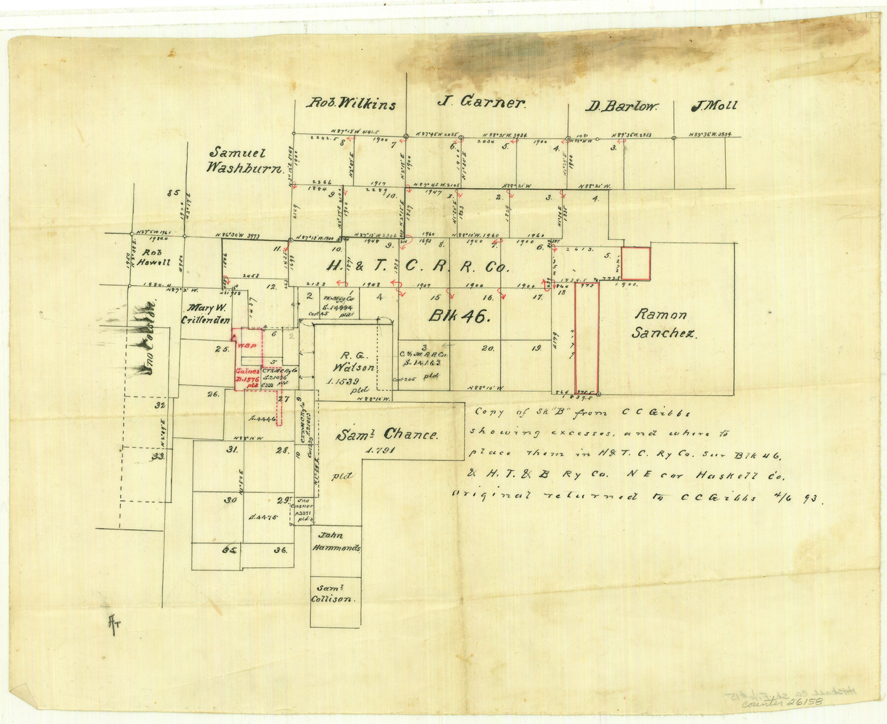
Haskell County Sketch File 15
[Sketch and connecting line from common north corners of 5 and 6, H. T. & B. RR. Co. to Ramon Sanches]
-
Map/Doc
26158
-
Collection
General Map Collection
-
Object Dates
1893/1/5 (Creation Date)
1893/4/1 (File Date)
1892/10/1 (Survey Date)
-
People and Organizations
J.A. Fisher (Surveyor/Engineer)
-
Counties
Haskell Knox Baylor Throckmorton
-
Subjects
Surveying Sketch File
-
Height x Width
13.5 x 16.5 inches
34.3 x 41.9 cm
-
Medium
paper, manuscript
-
Features
Millers Creek
Part of: General Map Collection
Sutton County

Print $40.00
- Digital $50.00
Sutton County
1941
Size 42.3 x 56.8 inches
Map/Doc 63052
Fort Bend County Sketch File 35

Print $4.00
- Digital $50.00
Fort Bend County Sketch File 35
Size 11.5 x 7.3 inches
Map/Doc 23005
Castro County Sketch File 4d

Print $4.00
- Digital $50.00
Castro County Sketch File 4d
Size 13.6 x 8.8 inches
Map/Doc 17471
Eastland County Working Sketch 20

Print $20.00
- Digital $50.00
Eastland County Working Sketch 20
1920
Size 38.0 x 23.5 inches
Map/Doc 68801
United States Atlantic and Gulf Coasts Including Puerto Rico and the Virgin Islands

Print $40.00
- Digital $50.00
United States Atlantic and Gulf Coasts Including Puerto Rico and the Virgin Islands
1992
Size 21.6 x 60.4 inches
Map/Doc 76124
Newton County Boundary File 1

Print $4.00
- Digital $50.00
Newton County Boundary File 1
Size 14.3 x 8.8 inches
Map/Doc 57614
Coryell County Sketch File 25

Print $4.00
- Digital $50.00
Coryell County Sketch File 25
1873
Size 12.8 x 8.3 inches
Map/Doc 19391
Bell County Sketch File 3

Print $4.00
- Digital $50.00
Bell County Sketch File 3
1848
Size 12.6 x 8.4 inches
Map/Doc 14367
Frio County Sketch File 17

Print $6.00
- Digital $50.00
Frio County Sketch File 17
1955
Size 14.3 x 8.7 inches
Map/Doc 23152
Cass County Working Sketch 32

Print $20.00
- Digital $50.00
Cass County Working Sketch 32
1982
Size 24.0 x 22.6 inches
Map/Doc 67935
Brown County Working Sketch Graphic Index

Print $20.00
- Digital $50.00
Brown County Working Sketch Graphic Index
1944
Size 47.6 x 37.1 inches
Map/Doc 76480
Mason County Sketch File 23

Print $42.00
- Digital $50.00
Mason County Sketch File 23
1932
Size 11.2 x 8.8 inches
Map/Doc 30723
You may also like
Pecos County Sketch File 62

Print $40.00
- Digital $50.00
Pecos County Sketch File 62
1919
Size 10.5 x 24.6 inches
Map/Doc 33790

Brewster County Rolled Sketch 114

Print $20.00
- Digital $50.00
Brewster County Rolled Sketch 114
1964
Size 11.7 x 18.4 inches
Map/Doc 5265
Titus County Boundary File 2

Print $6.00
- Digital $50.00
Titus County Boundary File 2
Size 7.7 x 6.7 inches
Map/Doc 59297
Texas, Matagorda Peninsula, Cotton Bayou

Print $6.00
- Digital $50.00
Texas, Matagorda Peninsula, Cotton Bayou
Size 31.5 x 34.6 inches
Map/Doc 69986
Irion County Sketch File 6

Print $20.00
- Digital $50.00
Irion County Sketch File 6
1900
Size 19.1 x 27.8 inches
Map/Doc 11824
Val Verde County Working Sketch Graphic Index, Sheet 1 (Sketches 1 to 25)

Print $20.00
- Digital $50.00
Val Verde County Working Sketch Graphic Index, Sheet 1 (Sketches 1 to 25)
1944
Size 40.4 x 36.5 inches
Map/Doc 76724
Flight Mission No. BRA-16M, Frame 48, Jefferson County

Print $20.00
- Digital $50.00
Flight Mission No. BRA-16M, Frame 48, Jefferson County
1953
Size 18.6 x 22.5 inches
Map/Doc 85665
[Surveys in Austin's Colony along the Navidad River, Caney Fork, and upper Rocky Creek]
![201, [Surveys in Austin's Colony along the Navidad River, Caney Fork, and upper Rocky Creek], General Map Collection](https://historictexasmaps.com/wmedia_w700/maps/201-1.tif.jpg)
Print $20.00
- Digital $50.00
[Surveys in Austin's Colony along the Navidad River, Caney Fork, and upper Rocky Creek]
1831
Size 20.5 x 26.7 inches
Map/Doc 201
Menard County Boundary File 12

Print $66.00
- Digital $50.00
Menard County Boundary File 12
Size 8.7 x 8.7 inches
Map/Doc 57099
Schleicher Co.

Print $20.00
- Digital $50.00
Schleicher Co.
1893
Size 20.8 x 29.3 inches
Map/Doc 63025
Duval County Sketch File 36a

Print $10.00
- Digital $50.00
Duval County Sketch File 36a
1935
Size 11.4 x 8.8 inches
Map/Doc 21380