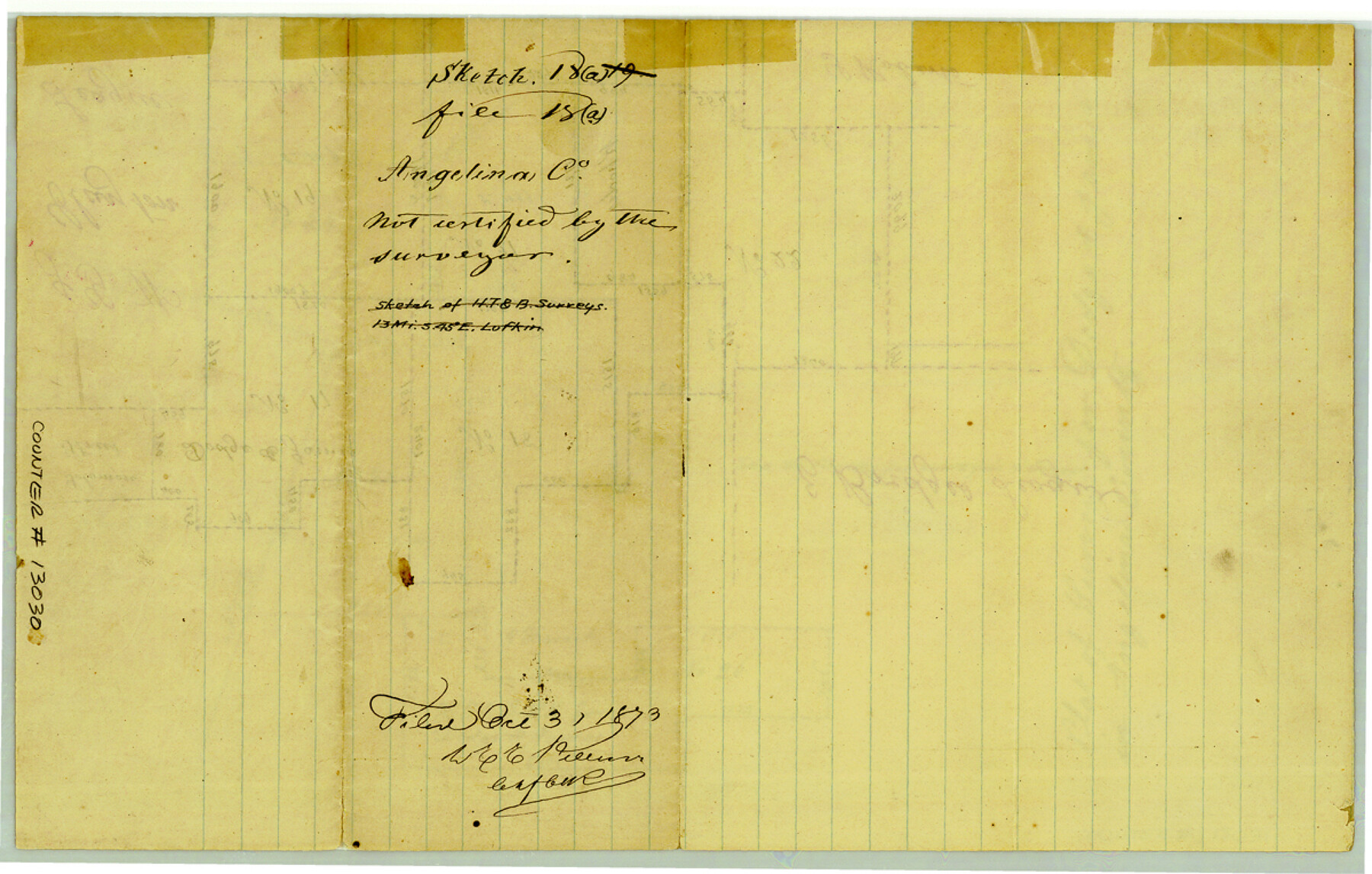
Angelina County Sketch File 18a
[Plat of surveys for Dodge and James in Angelina County]
-
Map/Doc
13030
-
Collection
General Map Collection
-
Object Dates
1873/10/3 (File Date)
-
Counties
Angelina
-
Subjects
Surveying Sketch File
-
Height x Width
7.7 x 12.0 inches
19.6 x 30.5 cm
-
Medium
paper, manuscript
Part of: General Map Collection
Zavala County Working Sketch 19
![62094, Zavala County Working Sketch 19, General Map Collection](https://historictexasmaps.com/wmedia_w700/maps/62094.tif.jpg)
Print $40.00
- Digital $50.00
Zavala County Working Sketch 19
Size 16.2 x 59.1 inches
Map/Doc 62094
Duval County Working Sketch 16
![68729, Duval County Working Sketch 16, General Map Collection](https://historictexasmaps.com/wmedia_w700/maps/68729.tif.jpg)
Print $20.00
- Digital $50.00
Duval County Working Sketch 16
Size 14.6 x 25.3 inches
Map/Doc 68729
Upton County Sketch File 39
![38907, Upton County Sketch File 39, General Map Collection](https://historictexasmaps.com/wmedia_w700/pdf_converted_jpg/qi_pdf_thumbnail_14734.jpg)
Print $12.00
- Digital $50.00
Upton County Sketch File 39
1953
Size 11.2 x 8.8 inches
Map/Doc 38907
Kleberg County Rolled Sketch 9
![6551, Kleberg County Rolled Sketch 9, General Map Collection](https://historictexasmaps.com/wmedia_w700/maps/6551.tif.jpg)
Print $20.00
- Digital $50.00
Kleberg County Rolled Sketch 9
1954
Size 36.9 x 21.3 inches
Map/Doc 6551
Nueces County Sketch File 68
![33000, Nueces County Sketch File 68, General Map Collection](https://historictexasmaps.com/wmedia_w700/pdf_converted_jpg/qi_pdf_thumbnail_13389.jpg)
Print $8.00
- Digital $50.00
Nueces County Sketch File 68
Size 11.0 x 8.7 inches
Map/Doc 33000
Public Land on Mustang Island, Nueces County
![1997, Public Land on Mustang Island, Nueces County, General Map Collection](https://historictexasmaps.com/wmedia_w700/maps/1997-1.tif.jpg)
Print $20.00
- Digital $50.00
Public Land on Mustang Island, Nueces County
1910
Size 17.0 x 17.5 inches
Map/Doc 1997
Brewster County Working Sketch 103
![67703, Brewster County Working Sketch 103, General Map Collection](https://historictexasmaps.com/wmedia_w700/maps/67703.tif.jpg)
Print $40.00
- Digital $50.00
Brewster County Working Sketch 103
Size 48.4 x 31.1 inches
Map/Doc 67703
Cameron County Rolled Sketch 17
![8570, Cameron County Rolled Sketch 17, General Map Collection](https://historictexasmaps.com/wmedia_w700/maps/8570-1.tif.jpg)
Print $40.00
- Digital $50.00
Cameron County Rolled Sketch 17
1937
Size 49.1 x 37.9 inches
Map/Doc 8570
Trinity County Working Sketch 19
![69468, Trinity County Working Sketch 19, General Map Collection](https://historictexasmaps.com/wmedia_w700/maps/69468.tif.jpg)
Print $3.00
- Digital $50.00
Trinity County Working Sketch 19
Size 14.7 x 11.1 inches
Map/Doc 69468
Nueces County Rolled Sketch 119
![](https://historictexasmaps.com/wmedia_w700/pdf_converted_jpg/qi_pdf_thumbnail_67923.jpg)
Print $90.00
Nueces County Rolled Sketch 119
1994
Size 26.1 x 36.5 inches
Map/Doc 7151
Presidio County Rolled Sketch 102
![7384, Presidio County Rolled Sketch 102, General Map Collection](https://historictexasmaps.com/wmedia_w700/maps/7384.tif.jpg)
Print $20.00
- Digital $50.00
Presidio County Rolled Sketch 102
1957
Size 22.8 x 17.4 inches
Map/Doc 7384
Goliad County Sketch File 10
![24226, Goliad County Sketch File 10, General Map Collection](https://historictexasmaps.com/wmedia_w700/pdf_converted_jpg/qi_pdf_thumbnail_11405.jpg)
Print $4.00
- Digital $50.00
Goliad County Sketch File 10
1859
Size 9.3 x 8.1 inches
Map/Doc 24226
You may also like
Uvalde County Working Sketch 23
![72093, Uvalde County Working Sketch 23, General Map Collection](https://historictexasmaps.com/wmedia_w700/maps/72093.tif.jpg)
Print $5.00
- Digital $50.00
Uvalde County Working Sketch 23
Size 32.0 x 26.6 inches
Map/Doc 72093
Cooke County Boundary File 2
![51840, Cooke County Boundary File 2, General Map Collection](https://historictexasmaps.com/wmedia_w700/pdf_converted_jpg/qi_pdf_thumbnail_15816.jpg)
Print $19.00
- Digital $50.00
Cooke County Boundary File 2
Size 12.1 x 7.6 inches
Map/Doc 51840
Guadalupe County, Texas
![491, Guadalupe County, Texas, Maddox Collection](https://historictexasmaps.com/wmedia_w700/maps/491.tif.jpg)
Print $20.00
- Digital $50.00
Guadalupe County, Texas
1880
Size 24.7 x 22.5 inches
Map/Doc 491
[Galveston, Harrisburg & San Antonio Railway]
![64407, [Galveston, Harrisburg & San Antonio Railway], General Map Collection](https://historictexasmaps.com/wmedia_w700/maps/64407.tif.jpg)
Print $20.00
- Digital $50.00
[Galveston, Harrisburg & San Antonio Railway]
1892
Size 13.9 x 34.0 inches
Map/Doc 64407
Colorado County Working Sketch 9
![68109, Colorado County Working Sketch 9, General Map Collection](https://historictexasmaps.com/wmedia_w700/maps/68109.tif.jpg)
Print $20.00
- Digital $50.00
Colorado County Working Sketch 9
Size 12.0 x 15.7 inches
Map/Doc 68109
Cameron County Sketch File 1
![36024, Cameron County Sketch File 1, General Map Collection](https://historictexasmaps.com/wmedia_w700/pdf_converted_jpg/qi_pdf_thumbnail_14078.jpg)
Print $7.00
- Digital $50.00
Cameron County Sketch File 1
1849
Size 10.9 x 8.6 inches
Map/Doc 36024
[Connecting line from southwest corner of S. K. & K. Blk M6 to southwest corner I. & G. N. Blk. 6]
![90411, [Connecting line from southwest corner of S. K. & K. Blk M6 to southwest corner I. & G. N. Blk. 6], Twichell Survey Records](https://historictexasmaps.com/wmedia_w700/maps/90411-1.tif.jpg)
Print $20.00
- Digital $50.00
[Connecting line from southwest corner of S. K. & K. Blk M6 to southwest corner I. & G. N. Blk. 6]
Size 26.4 x 26.9 inches
Map/Doc 90411
Childress Co.
![73105, Childress Co., General Map Collection](https://historictexasmaps.com/wmedia_w700/maps/73105.tif.jpg)
Print $20.00
- Digital $50.00
Childress Co.
1978
Size 46.2 x 35.0 inches
Map/Doc 73105
[West and North lines of the Panhandle]
![90576, [West and North lines of the Panhandle], Twichell Survey Records](https://historictexasmaps.com/wmedia_w700/maps/90576-1.tif.jpg)
Print $20.00
- Digital $50.00
[West and North lines of the Panhandle]
1885
Size 22.0 x 32.1 inches
Map/Doc 90576
Geographical Observations on the Inner Margins of the Border and Coastal Reserves of Texas, 1824-1836
![](https://historictexasmaps.com/wmedia_w700/pdf_converted_jpg/qi_pdf_thumbnail_67155.jpg)
Geographical Observations on the Inner Margins of the Border and Coastal Reserves of Texas, 1824-1836
2022
Map/Doc 97131
Sketch of Block B, GH & H RR & Blk C, CT RR Co, with surrounding & conflicting surveys in Knox & Baylor Counties
![75784, Sketch of Block B, GH & H RR & Blk C, CT RR Co, with surrounding & conflicting surveys in Knox & Baylor Counties, Maddox Collection](https://historictexasmaps.com/wmedia_w700/maps/75784.tif.jpg)
Print $20.00
- Digital $50.00
Sketch of Block B, GH & H RR & Blk C, CT RR Co, with surrounding & conflicting surveys in Knox & Baylor Counties
Size 24.9 x 17.9 inches
Map/Doc 75784
Jefferson County Rolled Sketch 27
![9292, Jefferson County Rolled Sketch 27, General Map Collection](https://historictexasmaps.com/wmedia_w700/maps/9292.tif.jpg)
Print $20.00
- Digital $50.00
Jefferson County Rolled Sketch 27
1948
Size 24.2 x 46.6 inches
Map/Doc 9292