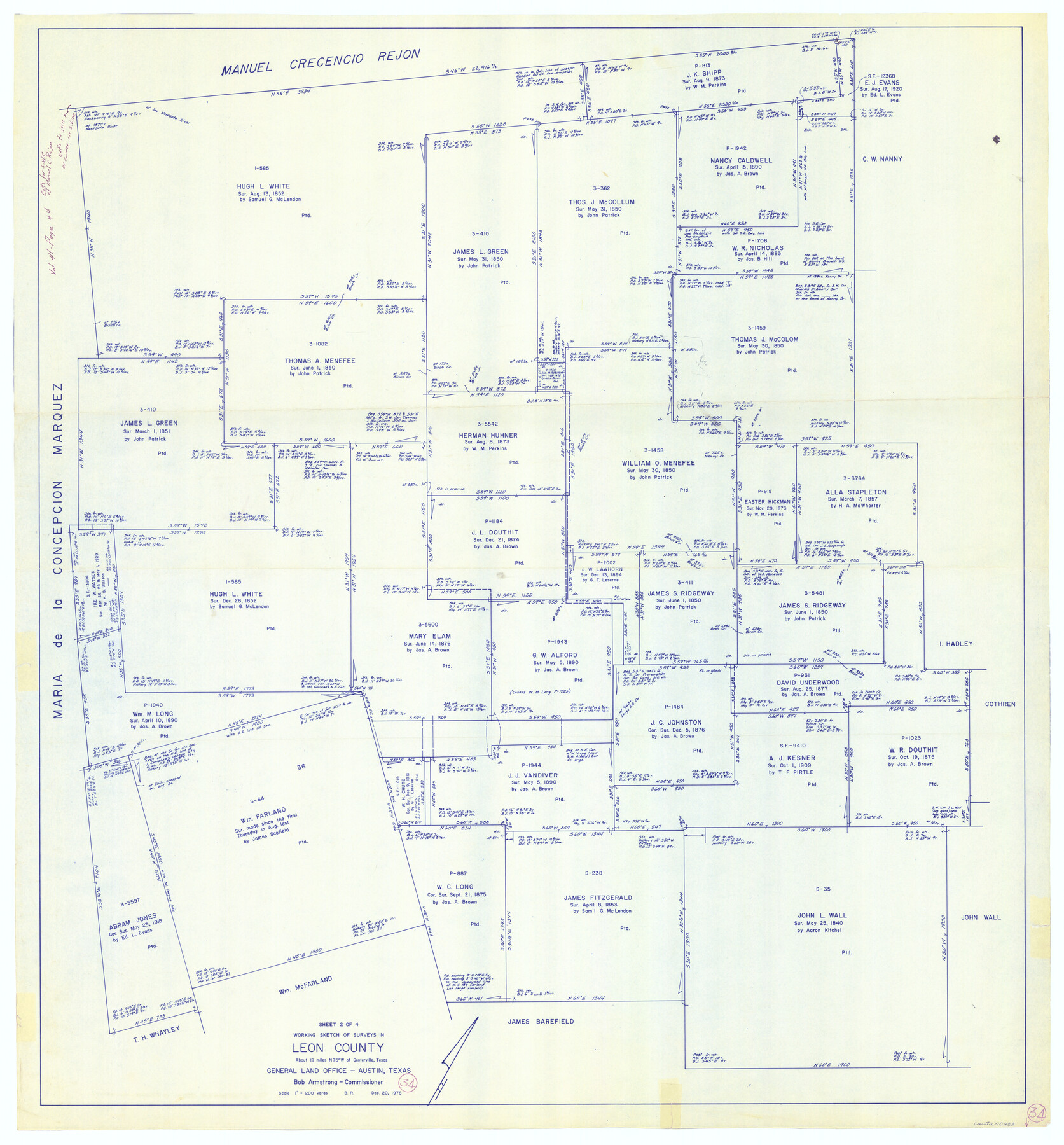
Leon County Working Sketch 34
-
Map/Doc
70433
-
Collection
General Map Collection
-
Object Dates
12/20/1978 (Creation Date)
-
People and Organizations
Beverly Robison (Draftsman)
-
Counties
Leon
-
Subjects
Surveying Working Sketch
-
Height x Width
45.1 x 41.9 inches
114.6 x 106.4 cm
-
Scale
1" = 200 varas
Part of: General Map Collection
Bexar County Working Sketch 20

Print $20.00
- Digital $50.00
Bexar County Working Sketch 20
1982
Size 42.4 x 43.6 inches
Map/Doc 67336
Flight Mission No. CRC-1R, Frame 154, Chambers County

Print $20.00
- Digital $50.00
Flight Mission No. CRC-1R, Frame 154, Chambers County
1956
Size 18.9 x 22.5 inches
Map/Doc 84716
Baylor County Sketch File 24

Print $6.00
- Digital $50.00
Baylor County Sketch File 24
1934
Size 13.9 x 8.8 inches
Map/Doc 14209
Burnet County Working Sketch 27

Print $20.00
- Digital $50.00
Burnet County Working Sketch 27
2025
Size 24.5 x 36.0 inches
Map/Doc 97419
Terrell County Working Sketch 19

Print $20.00
- Digital $50.00
Terrell County Working Sketch 19
1932
Size 18.8 x 25.7 inches
Map/Doc 62169
Freestone County Working Sketch 29

Print $20.00
- Digital $50.00
Freestone County Working Sketch 29
1994
Size 36.0 x 45.5 inches
Map/Doc 69271
Scurry County Rolled Sketch 2

Print $20.00
- Digital $50.00
Scurry County Rolled Sketch 2
Size 44.0 x 44.9 inches
Map/Doc 9911
Lamb County Boundary File 1e

Print $10.00
- Digital $50.00
Lamb County Boundary File 1e
Size 11.3 x 8.8 inches
Map/Doc 56053
Copy of Surveyor's Field Book, Morris Browning - In Blocks 7, 5 & 4, I&GNRRCo., Hutchinson and Carson Counties, Texas

Print $2.00
- Digital $50.00
Copy of Surveyor's Field Book, Morris Browning - In Blocks 7, 5 & 4, I&GNRRCo., Hutchinson and Carson Counties, Texas
1888
Size 7.0 x 8.9 inches
Map/Doc 62268
Flight Mission No. DAG-17K, Frame 73, Matagorda County

Print $20.00
- Digital $50.00
Flight Mission No. DAG-17K, Frame 73, Matagorda County
1952
Size 18.5 x 22.4 inches
Map/Doc 86332
Borden County Working Sketch Graphic Index

Print $20.00
- Digital $50.00
Borden County Working Sketch Graphic Index
1977
Size 45.7 x 34.8 inches
Map/Doc 76468
Panola County Working Sketch 35

Print $40.00
- Digital $50.00
Panola County Working Sketch 35
1983
Map/Doc 71444
You may also like
Culberson County Sketch File 36

Print $28.00
- Digital $50.00
Culberson County Sketch File 36
1957
Size 11.3 x 8.7 inches
Map/Doc 20302
Eastland County Working Sketch 55

Print $20.00
- Digital $50.00
Eastland County Working Sketch 55
1984
Size 33.5 x 37.8 inches
Map/Doc 68836
Bexar County Sketch File 36c

Print $20.00
- Digital $50.00
Bexar County Sketch File 36c
1874
Size 19.3 x 26.4 inches
Map/Doc 10922
San Patricio County Rolled Sketch 27B

Print $40.00
- Digital $50.00
San Patricio County Rolled Sketch 27B
Size 50.3 x 38.4 inches
Map/Doc 9892
Map of Matagorda County

Print $20.00
- Digital $50.00
Map of Matagorda County
1839
Size 23.5 x 32.2 inches
Map/Doc 3844
DeWitt County Boundary File 2a

Print $2.00
- Digital $50.00
DeWitt County Boundary File 2a
Size 10.7 x 8.1 inches
Map/Doc 52513
Map of Bee County

Print $20.00
- Digital $50.00
Map of Bee County
1879
Size 25.1 x 22.7 inches
Map/Doc 3289
Pecos County Working Sketch 7

Print $20.00
- Digital $50.00
Pecos County Working Sketch 7
1892
Size 25.4 x 18.3 inches
Map/Doc 71477
Harris County NRC Article 33.136 Sketch 11

Print $28.00
- Digital $50.00
Harris County NRC Article 33.136 Sketch 11
2007
Size 24.0 x 36.0 inches
Map/Doc 94658
Presidio County Rolled Sketch 24

Print $40.00
- Digital $50.00
Presidio County Rolled Sketch 24
1886
Size 158.3 x 23.4 inches
Map/Doc 9765
Amistad International Reservoir on Rio Grande Key Sheet

Print $20.00
- Digital $50.00
Amistad International Reservoir on Rio Grande Key Sheet
1960
Size 13.0 x 32.4 inches
Map/Doc 73345
Nueces County Sketch File 56

Print $113.00
- Digital $50.00
Nueces County Sketch File 56
1973
Size 10.1 x 9.3 inches
Map/Doc 32874