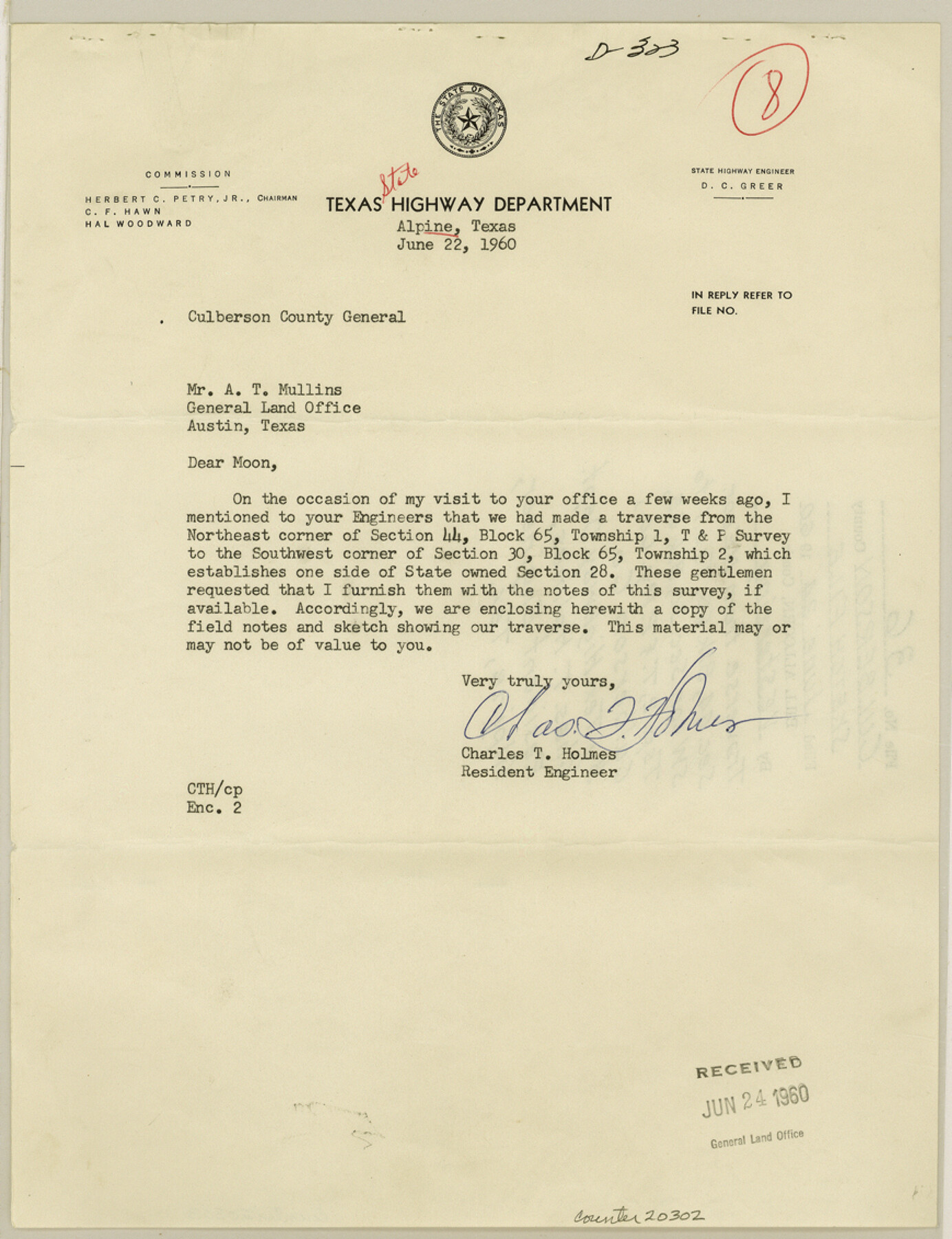
Culberson County Sketch File 36
[Traverse from northeast corner of section 44, Block 65, Township 1 to southwest corner of section 30, Block 65, Township 2, T. & P. RR. Co.]
-
Map/Doc
20302
-
Collection
General Map Collection
-
Object Dates
1960/6/24 (File Date)
1957 (Creation Date)
-
People and Organizations
Charles T. Holmes (Surveyor/Engineer)
-
Counties
Culberson
-
Subjects
Surveying Sketch File
-
Height x Width
11.3 x 8.7 inches
28.7 x 22.1 cm
-
Medium
multi-page, multi-format
-
Scale
1:500
-
Features
Guadalupe Peak
El Capitan Peak
U.S. Highway 62
U.S. Highway 180
Part of: General Map Collection
Angelina County Sketch File 8

Print $22.00
- Digital $50.00
Angelina County Sketch File 8
1858
Size 8.0 x 3.5 inches
Map/Doc 12935
Kaufman County Sketch File 1

Print $4.00
- Digital $50.00
Kaufman County Sketch File 1
Size 8.3 x 8.3 inches
Map/Doc 28624
Lipscomb County Rolled Sketch 1

Print $40.00
- Digital $50.00
Lipscomb County Rolled Sketch 1
Size 65.0 x 15.8 inches
Map/Doc 9449
Flight Mission No. BRA-8M, Frame 132, Jefferson County

Print $20.00
- Digital $50.00
Flight Mission No. BRA-8M, Frame 132, Jefferson County
1953
Size 18.7 x 22.3 inches
Map/Doc 85628
Kent County Rolled Sketch A

Print $20.00
- Digital $50.00
Kent County Rolled Sketch A
1902
Size 23.9 x 36.8 inches
Map/Doc 6477
Wichita County

Print $20.00
- Digital $50.00
Wichita County
1971
Size 39.1 x 40.8 inches
Map/Doc 95673
Roberts County Boundary File 2

Print $12.00
- Digital $50.00
Roberts County Boundary File 2
Size 9.9 x 6.4 inches
Map/Doc 58333
Fannin County Texas

Print $20.00
- Digital $50.00
Fannin County Texas
1870
Size 23.9 x 19.3 inches
Map/Doc 4542
La Salle County Sketch File 49

Print $20.00
- Digital $50.00
La Salle County Sketch File 49
1942
Size 47.7 x 14.9 inches
Map/Doc 10519
Orange County Sketch File 10

Print $4.00
- Digital $50.00
Orange County Sketch File 10
1876
Size 8.4 x 12.8 inches
Map/Doc 33317
Wichita County Sketch File 10

Print $4.00
- Digital $50.00
Wichita County Sketch File 10
Size 12.7 x 8.3 inches
Map/Doc 40054
Van Zandt County Sketch File 9a

Print $4.00
- Digital $50.00
Van Zandt County Sketch File 9a
1858
Size 12.4 x 8.0 inches
Map/Doc 39393
You may also like
Kimble County Working Sketch 50

Print $20.00
- Digital $50.00
Kimble County Working Sketch 50
1952
Size 34.8 x 22.1 inches
Map/Doc 70118
[E. L. & R.R. Block 1, G. C. & S. F. Blocks 1 & 2, T. R. R. Block 4]
![91280, [E. L. & R.R. Block 1, G. C. & S. F. Blocks 1 & 2, T. R. R. Block 4], Twichell Survey Records](https://historictexasmaps.com/wmedia_w700/maps/91280-1.tif.jpg)
Print $20.00
- Digital $50.00
[E. L. & R.R. Block 1, G. C. & S. F. Blocks 1 & 2, T. R. R. Block 4]
Size 8.7 x 19.3 inches
Map/Doc 91280
Flight Mission No. DIX-10P, Frame 146, Aransas County

Print $20.00
- Digital $50.00
Flight Mission No. DIX-10P, Frame 146, Aransas County
1956
Size 18.6 x 22.4 inches
Map/Doc 83948
Van Zandt County Sketch File 2

Print $9.00
- Digital $50.00
Van Zandt County Sketch File 2
1852
Size 12.9 x 4.9 inches
Map/Doc 39359
Sherman County Boundary File Index

Print $2.00
- Digital $50.00
Sherman County Boundary File Index
Size 8.8 x 13.2 inches
Map/Doc 58750
[Blocks D, Q, and Z]
![92522, [Blocks D, Q, and Z], Twichell Survey Records](https://historictexasmaps.com/wmedia_w700/maps/92522-1.tif.jpg)
Print $20.00
- Digital $50.00
[Blocks D, Q, and Z]
Size 17.9 x 22.6 inches
Map/Doc 92522
Callahan County Rolled Sketch 4

Print $20.00
- Digital $50.00
Callahan County Rolled Sketch 4
1952
Size 20.8 x 30.6 inches
Map/Doc 5381
Southern Pacific Railway and Steamship Lines

Print $20.00
- Digital $50.00
Southern Pacific Railway and Steamship Lines
1900
Size 23.8 x 35.5 inches
Map/Doc 96586
Zavala County Working Sketch 21

Print $20.00
- Digital $50.00
Zavala County Working Sketch 21
1979
Size 23.0 x 18.0 inches
Map/Doc 62096
Van Zandt County Sketch File 38

Print $4.00
- Digital $50.00
Van Zandt County Sketch File 38
1871
Size 8.2 x 10.1 inches
Map/Doc 39482
Montague County Sketch File 23

Print $6.00
- Digital $50.00
Montague County Sketch File 23
1941
Size 13.9 x 8.4 inches
Map/Doc 31753
Stieler Map of 1879

Print $4.00
- Digital $50.00
Stieler Map of 1879
1879
Size 28.9 x 23.0 inches
Map/Doc 76057