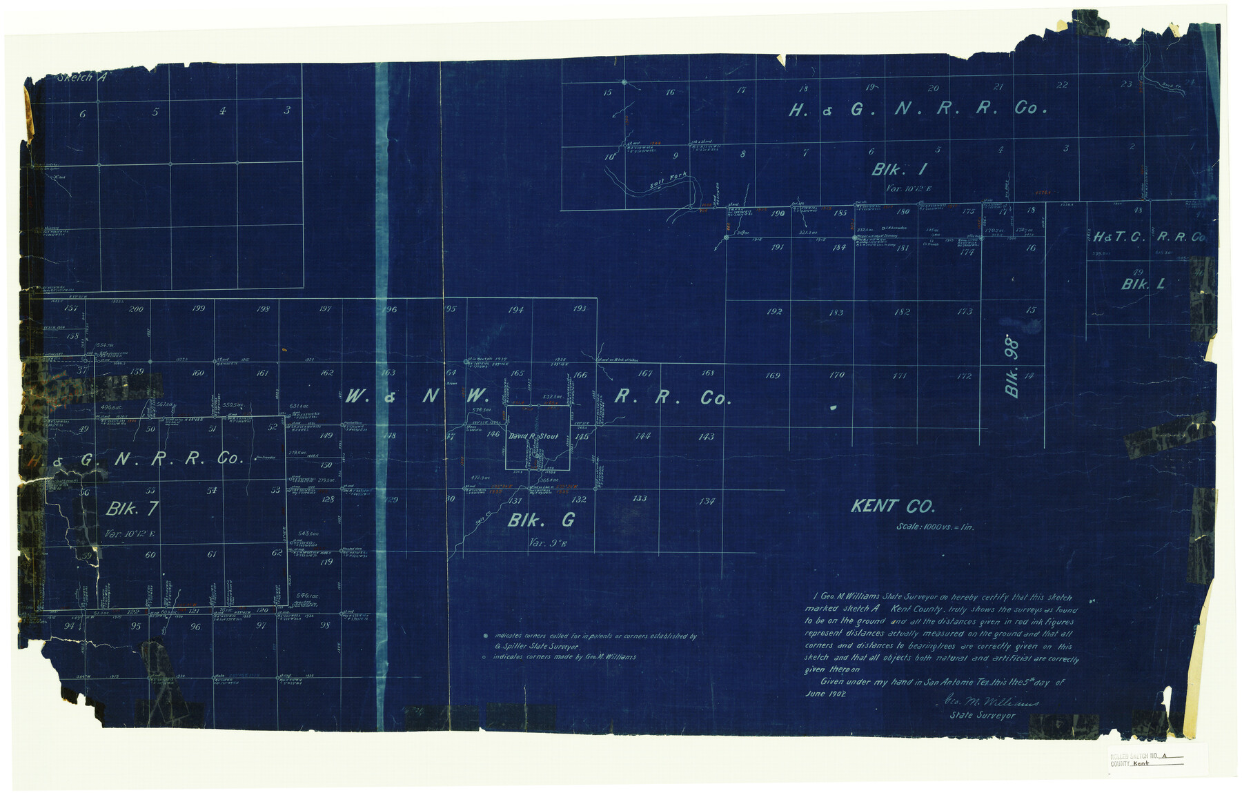
Kent County Rolled Sketch A
[Sketch showing a portion of Blocks 1, G & 7, Kent County, Texas]
-
Map/Doc
6477
-
Collection
General Map Collection
-
Object Dates
6/5/1902 (Creation Date)
-
People and Organizations
Geo. M. Williams (Surveyor/Engineer)
-
Counties
Kent
-
Subjects
Surveying Rolled Sketch
-
Height x Width
23.9 x 36.8 inches
60.7 x 93.5 cm
-
Medium
blueprint/diazo
-
Scale
1" = 1000 varas
Part of: General Map Collection
Brewster County Rolled Sketch 145

Print $20.00
- Digital $50.00
Brewster County Rolled Sketch 145
1944
Size 24.1 x 18.5 inches
Map/Doc 5312
Newton County Working Sketch 32

Print $20.00
- Digital $50.00
Newton County Working Sketch 32
1955
Size 22.9 x 24.0 inches
Map/Doc 71278
Middle Sulphur and South Sulphur Rivers, Horton Sheet

Print $20.00
- Digital $50.00
Middle Sulphur and South Sulphur Rivers, Horton Sheet
1925
Size 42.2 x 40.3 inches
Map/Doc 65171
Map of Nolan County

Print $20.00
- Digital $50.00
Map of Nolan County
1896
Size 28.8 x 23.5 inches
Map/Doc 3915
No. 2 Chart of Corpus Christi Pass, Texas

Print $20.00
- Digital $50.00
No. 2 Chart of Corpus Christi Pass, Texas
1878
Size 18.3 x 27.3 inches
Map/Doc 73021
Coke County Rolled Sketch 22

Print $20.00
- Digital $50.00
Coke County Rolled Sketch 22
1957
Size 18.2 x 22.6 inches
Map/Doc 5523
Kimble County Rolled Sketch 23

Print $20.00
- Digital $50.00
Kimble County Rolled Sketch 23
Size 16.0 x 21.0 inches
Map/Doc 6513
Presidio County Sketch File 82

Print $22.00
- Digital $50.00
Presidio County Sketch File 82
1949
Size 14.3 x 8.8 inches
Map/Doc 34711
Eastland County Sketch File 14

Print $8.00
- Digital $50.00
Eastland County Sketch File 14
Size 11.5 x 9.2 inches
Map/Doc 21595
Stonewall County Working Sketch 31

Print $20.00
- Digital $50.00
Stonewall County Working Sketch 31
1983
Size 42.6 x 42.9 inches
Map/Doc 62338
Webb County Sketch File 14

Print $7.00
- Digital $50.00
Webb County Sketch File 14
1877
Size 10.0 x 8.2 inches
Map/Doc 39807
Mason County Working Sketch 22

Print $20.00
- Digital $50.00
Mason County Working Sketch 22
2000
Size 31.1 x 30.8 inches
Map/Doc 70858
You may also like
Bandera County Working Sketch 57

Print $20.00
- Digital $50.00
Bandera County Working Sketch 57
1991
Size 38.5 x 46.8 inches
Map/Doc 67653
[Sketch for Mineral Application 1112 - Colorado River, H. E. Chambers]
![65640, [Sketch for Mineral Application 1112 - Colorado River, H. E. Chambers], General Map Collection](https://historictexasmaps.com/wmedia_w700/maps/65640.tif.jpg)
Print $20.00
- Digital $50.00
[Sketch for Mineral Application 1112 - Colorado River, H. E. Chambers]
1918
Size 17.2 x 28.3 inches
Map/Doc 65640
Galveston County Rolled Sketch 27B

Print $20.00
- Digital $50.00
Galveston County Rolled Sketch 27B
Size 13.1 x 10.4 inches
Map/Doc 5963
Copy of Surveyor's Field Book, Morris Browning - In Blocks 7, 5 & 4, I&GNRRCo., Hutchinson and Carson Counties, Texas

Print $2.00
- Digital $50.00
Copy of Surveyor's Field Book, Morris Browning - In Blocks 7, 5 & 4, I&GNRRCo., Hutchinson and Carson Counties, Texas
1888
Size 7.0 x 8.8 inches
Map/Doc 62278
Brewster County Working Sketch 119

Print $20.00
- Digital $50.00
Brewster County Working Sketch 119
1909
Size 29.3 x 29.0 inches
Map/Doc 67719
Stephens County Boundary File 81

Print $44.00
- Digital $50.00
Stephens County Boundary File 81
Size 9.2 x 3.8 inches
Map/Doc 58906
General Highway Map Cochran County, Texas

Print $40.00
- Digital $50.00
General Highway Map Cochran County, Texas
1942
Size 37.4 x 50.1 inches
Map/Doc 89851
Flight Mission No. CGI-4N, Frame 189, Cameron County

Print $20.00
- Digital $50.00
Flight Mission No. CGI-4N, Frame 189, Cameron County
1955
Size 18.5 x 22.2 inches
Map/Doc 84692
Hardin County Working Sketch 39, part 2

Print $40.00
- Digital $50.00
Hardin County Working Sketch 39, part 2
1985
Size 36.0 x 48.5 inches
Map/Doc 63438
Webb County Sketch File 60

Print $8.00
- Digital $50.00
Webb County Sketch File 60
1943
Size 14.4 x 8.9 inches
Map/Doc 39855
Armstrong County Working Sketch 6

Print $20.00
- Digital $50.00
Armstrong County Working Sketch 6
1929
Size 24.3 x 19.4 inches
Map/Doc 67237
[R. M. Thompson Block A, Jones County School Land, and vicinity]
![91202, [R. M. Thompson Block A, Jones County School Land, and vicinity], Twichell Survey Records](https://historictexasmaps.com/wmedia_w700/maps/91202-1.tif.jpg)
Print $20.00
- Digital $50.00
[R. M. Thompson Block A, Jones County School Land, and vicinity]
Size 15.8 x 30.0 inches
Map/Doc 91202