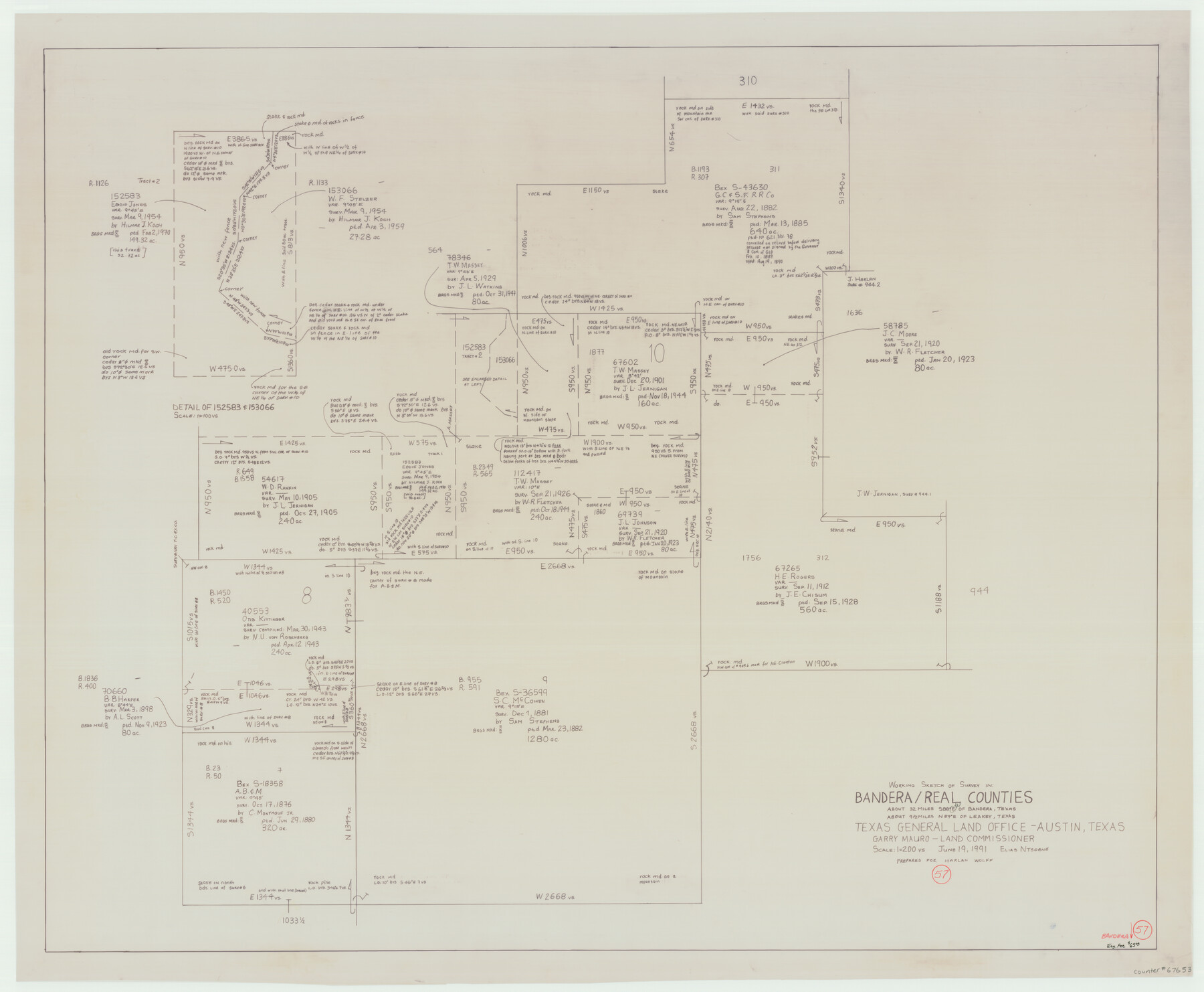
Bandera County Working Sketch 57
-
Map/Doc
67653
-
Collection
General Map Collection
-
Object Dates
6/19/1991 (Creation Date)
-
People and Organizations
Elias Ntsoane (Draftsman)
Garry Mauro (GLO Commissioner)
-
Counties
Bandera Real
-
Subjects
Surveying Working Sketch
-
Height x Width
38.5 x 46.8 inches
97.8 x 118.9 cm
-
Scale
1" = 200 varas
-
Comments
Surveys located about 32 miles South 88 degrees West of Bandera, Texas.
Part of: General Map Collection
Encinal County

Print $20.00
- Digital $50.00
Encinal County
1886
Size 32.2 x 23.6 inches
Map/Doc 3518
Flight Mission No. DCL-6C, Frame 52, Kenedy County

Print $20.00
- Digital $50.00
Flight Mission No. DCL-6C, Frame 52, Kenedy County
1943
Size 18.6 x 22.4 inches
Map/Doc 85894
Sutton County Working Sketch 33

Print $20.00
- Digital $50.00
Sutton County Working Sketch 33
1936
Size 23.3 x 32.2 inches
Map/Doc 62376
Calhoun County NRC Article 33.136 Location Key Sheet

Print $20.00
- Digital $50.00
Calhoun County NRC Article 33.136 Location Key Sheet
1973
Size 27.0 x 23.0 inches
Map/Doc 87906
[Surveys in the Bexar District along the Frio and Leona Rivers]
![136, [Surveys in the Bexar District along the Frio and Leona Rivers], General Map Collection](https://historictexasmaps.com/wmedia_w700/maps/136.tif.jpg)
Print $20.00
- Digital $50.00
[Surveys in the Bexar District along the Frio and Leona Rivers]
1842
Size 16.2 x 12.2 inches
Map/Doc 136
Duval County Sketch File 51

Print $20.00
- Digital $50.00
Duval County Sketch File 51
Size 19.1 x 33.8 inches
Map/Doc 11401
Hardin County Sketch File 10

Print $4.00
- Digital $50.00
Hardin County Sketch File 10
1862
Size 12.5 x 8.0 inches
Map/Doc 25110
Gregg County Working Sketch 22

Print $20.00
- Digital $50.00
Gregg County Working Sketch 22
1981
Size 23.2 x 21.5 inches
Map/Doc 63289
Cameron County

Print $20.00
- Digital $50.00
Cameron County
1976
Size 30.9 x 38.1 inches
Map/Doc 77230
Brewster County Working Sketch 4

Print $20.00
- Digital $50.00
Brewster County Working Sketch 4
1908
Size 15.7 x 20.5 inches
Map/Doc 67537
Mills County Sketch File 25

Print $8.00
- Digital $50.00
Mills County Sketch File 25
1949
Size 11.3 x 8.8 inches
Map/Doc 31674
Lavaca County Sketch File 1

Print $4.00
- Digital $50.00
Lavaca County Sketch File 1
1848
Size 12.7 x 8.2 inches
Map/Doc 29628
You may also like
Brown County Working Sketch 19

Print $20.00
- Digital $50.00
Brown County Working Sketch 19
1998
Size 37.1 x 34.8 inches
Map/Doc 67784
Refugio County

Print $20.00
- Digital $50.00
Refugio County
1872
Size 17.6 x 22.9 inches
Map/Doc 3987
Presidio County Sketch File 35B

Print $20.00
- Digital $50.00
Presidio County Sketch File 35B
1906
Size 11.8 x 20.7 inches
Map/Doc 11714
[Sketch for Mineral Application 19560 - 19588 - San Bernard River]
![65660, [Sketch for Mineral Application 19560 - 19588 - San Bernard River], General Map Collection](https://historictexasmaps.com/wmedia_w700/maps/65660.tif.jpg)
Print $40.00
- Digital $50.00
[Sketch for Mineral Application 19560 - 19588 - San Bernard River]
Size 98.0 x 33.0 inches
Map/Doc 65660
Howard County Sketch File 3

Print $12.00
- Digital $50.00
Howard County Sketch File 3
1909
Size 9.0 x 8.3 inches
Map/Doc 26855
Flight Mission No. DAG-24K, Frame 153, Matagorda County

Print $20.00
- Digital $50.00
Flight Mission No. DAG-24K, Frame 153, Matagorda County
1953
Size 17.3 x 18.8 inches
Map/Doc 86567
Jefferson County Working Sketch 30a

Print $20.00
- Digital $50.00
Jefferson County Working Sketch 30a
1977
Size 17.8 x 21.2 inches
Map/Doc 66573
[PSL Blocks C31-C39]
![90790, [PSL Blocks C31-C39], Twichell Survey Records](https://historictexasmaps.com/wmedia_w700/maps/90790-1.tif.jpg)
Print $20.00
- Digital $50.00
[PSL Blocks C31-C39]
Size 43.1 x 9.8 inches
Map/Doc 90790
La Salle County Sketch File 13

Print $6.00
- Digital $50.00
La Salle County Sketch File 13
Size 8.1 x 16.6 inches
Map/Doc 29477
Lampasas County Working Sketch 1

Print $20.00
- Digital $50.00
Lampasas County Working Sketch 1
Size 16.2 x 20.3 inches
Map/Doc 70278
Maverick County

Print $20.00
- Digital $50.00
Maverick County
1863
Size 24.4 x 36.6 inches
Map/Doc 3847
Galveston County NRC Article 33.136 Location Key Sheet

Print $20.00
- Digital $50.00
Galveston County NRC Article 33.136 Location Key Sheet
1995
Size 27.0 x 22.0 inches
Map/Doc 83592