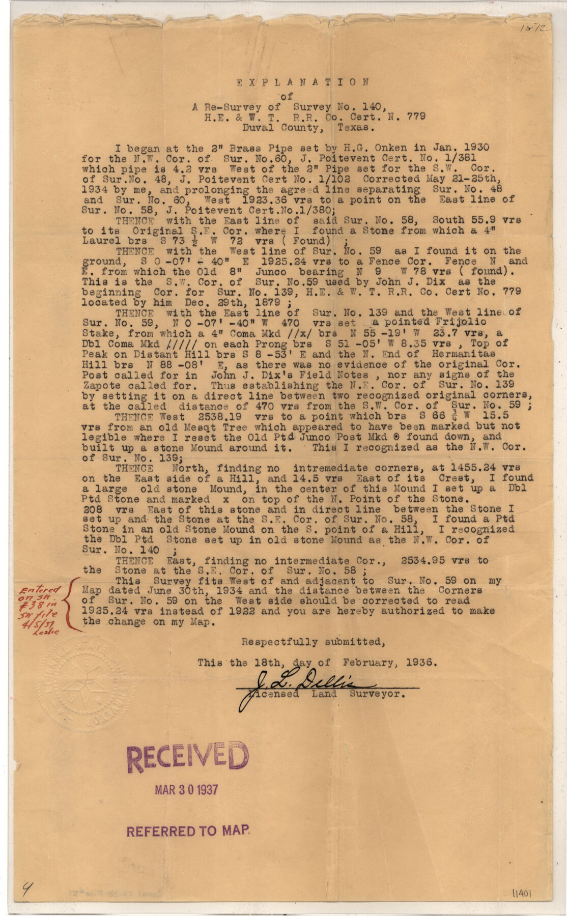
Duval County Sketch File 51
Map of Sur. No. 140, H.E.&W.T. RR. Co. Cert. No. 779 Duval County Texas
-
Map/Doc
11401
-
Collection
General Map Collection
-
Object Dates
1937/3/30 (File Date)
1936/2/15 (Survey Date)
-
People and Organizations
J.L. Dellis (Surveyor/Engineer)
-
Counties
Duval
-
Subjects
Surveying Sketch File
-
Height x Width
19.1 x 33.8 inches
48.5 x 85.9 cm
-
Medium
multi-page, multi-format
-
Scale
1:400
-
Features
Hermanitas Hill
Part of: General Map Collection
Coast Chart No. 208 - Pass Cavallo, Lavaca and San Antonio Bays, Texas

Print $20.00
- Digital $50.00
Coast Chart No. 208 - Pass Cavallo, Lavaca and San Antonio Bays, Texas
1888
Size 43.9 x 35.7 inches
Map/Doc 73376
[Plat of Trinity River w/ Midstream Profile in Liberty County by US Government 1899]
![65338, [Plat of Trinity River w/ Midstream Profile in Liberty County by US Government 1899], General Map Collection](https://historictexasmaps.com/wmedia_w700/maps/65338.tif.jpg)
Print $20.00
- Digital $50.00
[Plat of Trinity River w/ Midstream Profile in Liberty County by US Government 1899]
1899
Size 12.5 x 16.8 inches
Map/Doc 65338
Edwards County Rolled Sketch 27

Print $20.00
- Digital $50.00
Edwards County Rolled Sketch 27
1959
Size 18.0 x 33.2 inches
Map/Doc 5813
Coleman County

Print $40.00
- Digital $50.00
Coleman County
1945
Size 54.5 x 35.4 inches
Map/Doc 77241
[Sketch for Mineral Application 13441 - Trinity River, Miller's Lake, Charlotte Lake, Florence Dunn]
![65657, [Sketch for Mineral Application 13441 - Trinity River, Miller's Lake, Charlotte Lake, Florence Dunn], General Map Collection](https://historictexasmaps.com/wmedia_w700/maps/65657.tif.jpg)
Print $40.00
- Digital $50.00
[Sketch for Mineral Application 13441 - Trinity River, Miller's Lake, Charlotte Lake, Florence Dunn]
1925
Size 104.1 x 43.3 inches
Map/Doc 65657
Wichita County Sketch File 19

Print $20.00
- Digital $50.00
Wichita County Sketch File 19
Size 21.9 x 22.5 inches
Map/Doc 12681
Brewster County Working Sketch 59

Print $20.00
- Digital $50.00
Brewster County Working Sketch 59
1955
Size 24.6 x 19.0 inches
Map/Doc 67660
[Military surveys on headwaters of Red River]
![3099, [Military surveys on headwaters of Red River], General Map Collection](https://historictexasmaps.com/wmedia_w700/maps/3099-1.tif.jpg)
Print $20.00
- Digital $50.00
[Military surveys on headwaters of Red River]
1878
Size 31.6 x 39.0 inches
Map/Doc 3099
Jasper County

Print $40.00
- Digital $50.00
Jasper County
1946
Size 49.8 x 43.9 inches
Map/Doc 95542

Uvalde County Sketch File 11

Print $46.00
- Digital $50.00
Uvalde County Sketch File 11
1886
Size 12.1 x 13.1 inches
Map/Doc 38972
Cooke County Sketch File 36

Print $4.00
- Digital $50.00
Cooke County Sketch File 36
1881
Size 7.8 x 8.4 inches
Map/Doc 19304
You may also like
Map of Terry County

Print $2.00
- Digital $50.00
Map of Terry County
Size 7.6 x 8.3 inches
Map/Doc 92888
Wise County Sketch File 52

Print $20.00
- Digital $50.00
Wise County Sketch File 52
1982
Size 14.2 x 8.6 inches
Map/Doc 40619
Nueces County NRC Article 33.136 Sketch 7

Print $82.00
- Digital $50.00
Nueces County NRC Article 33.136 Sketch 7
2004
Size 32.7 x 47.0 inches
Map/Doc 81932
Map of Fannin County

Print $20.00
- Digital $50.00
Map of Fannin County
1845
Size 34.7 x 36.5 inches
Map/Doc 16827
[Missouri, Kansas & Texas Line Map through Bastrop County]
![64029, [Missouri, Kansas & Texas Line Map through Bastrop County], General Map Collection](https://historictexasmaps.com/wmedia_w700/maps/64029.tif.jpg)
Print $40.00
- Digital $50.00
[Missouri, Kansas & Texas Line Map through Bastrop County]
1916
Size 25.8 x 122.6 inches
Map/Doc 64029
United States - Gulf Coast - From Latitude 26° 33' to the Rio Grande Texas

Print $20.00
- Digital $50.00
United States - Gulf Coast - From Latitude 26° 33' to the Rio Grande Texas
1918
Size 18.4 x 24.1 inches
Map/Doc 72848
Houston County Sketch File 1b

Print $4.00
- Digital $50.00
Houston County Sketch File 1b
1857
Size 8.5 x 7.9 inches
Map/Doc 26744
Fort Bend County State Real Property Sketch 11

Print $40.00
- Digital $50.00
Fort Bend County State Real Property Sketch 11
1986
Size 34.6 x 43.2 inches
Map/Doc 61685
Presidio County Sketch File C

Print $40.00
- Digital $50.00
Presidio County Sketch File C
Size 12.9 x 12.2 inches
Map/Doc 34426
Blanco County Working Sketch 20

Print $20.00
- Digital $50.00
Blanco County Working Sketch 20
1960
Size 27.3 x 36.4 inches
Map/Doc 67380
Navigation Maps of Gulf Intracoastal Waterway, Port Arthur to Brownsville, Texas

Print $4.00
- Digital $50.00
Navigation Maps of Gulf Intracoastal Waterway, Port Arthur to Brownsville, Texas
1951
Size 16.7 x 21.6 inches
Map/Doc 65447
Hutchinson County

Print $20.00
- Digital $50.00
Hutchinson County
1891
Size 19.7 x 24.5 inches
Map/Doc 91155