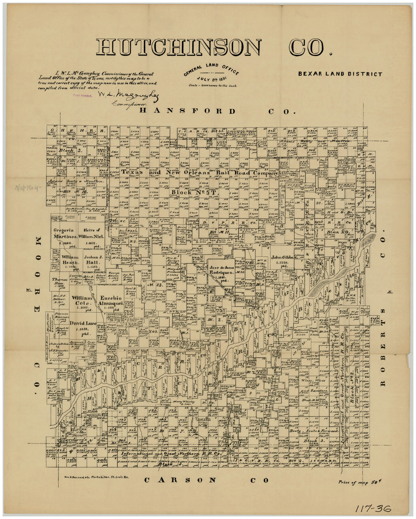
Hutchinson County
117-36
-
Map/Doc
91155
-
Collection
Twichell Survey Records
-
Object Dates
7/8/1891 (Creation Date)
-
Counties
Hutchinson
-
Subjects
County
-
Height x Width
19.7 x 24.5 inches
50.0 x 62.2 cm
Part of: Twichell Survey Records
Working Sketch in Dickens and Kent Counties

Print $20.00
- Digital $50.00
Working Sketch in Dickens and Kent Counties
1904
Size 24.2 x 30.5 inches
Map/Doc 91035
Working Sketch Archer County

Print $20.00
- Digital $50.00
Working Sketch Archer County
1924
Size 26.6 x 20.5 inches
Map/Doc 90257
[H. & T. C. Block 47 and part of G. & M. Block 3]
![91817, [H. & T. C. Block 47 and part of G. & M. Block 3], Twichell Survey Records](https://historictexasmaps.com/wmedia_w700/maps/91817-1.tif.jpg)
Print $20.00
- Digital $50.00
[H. & T. C. Block 47 and part of G. & M. Block 3]
Size 29.4 x 27.9 inches
Map/Doc 91817
Baker Addition to Lamesa, Part of Southwest Quarter Section 71, Block 35

Print $20.00
- Digital $50.00
Baker Addition to Lamesa, Part of Southwest Quarter Section 71, Block 35
Size 23.8 x 19.5 inches
Map/Doc 92576
St Francis situated in Potter and Carson Counties, Texas

Print $20.00
- Digital $50.00
St Francis situated in Potter and Carson Counties, Texas
Size 22.0 x 26.1 inches
Map/Doc 93109
Deaf Smith County

Print $20.00
- Digital $50.00
Deaf Smith County
1888
Size 28.7 x 19.8 inches
Map/Doc 90598
[Sketch Showing Wm. T. Brewer, John R. Taylor, Wm. F. Butler, Timothy DeVore, L. M. Thorn and adjoining surveys]
![89745, [Sketch Showing Wm. T. Brewer, John R. Taylor, Wm. F. Butler, Timothy DeVore, L. M. Thorn and adjoining surveys], Twichell Survey Records](https://historictexasmaps.com/wmedia_w700/maps/89745-1.tif.jpg)
Print $40.00
- Digital $50.00
[Sketch Showing Wm. T. Brewer, John R. Taylor, Wm. F. Butler, Timothy DeVore, L. M. Thorn and adjoining surveys]
Size 37.1 x 56.1 inches
Map/Doc 89745
[Central Part of County, near Morris County School Land Leagues]
![90486, [Central Part of County, near Morris County School Land Leagues], Twichell Survey Records](https://historictexasmaps.com/wmedia_w700/maps/90486-1.tif.jpg)
Print $20.00
- Digital $50.00
[Central Part of County, near Morris County School Land Leagues]
Size 13.4 x 26.3 inches
Map/Doc 90486
[Sketch showing surveys in the north half of Potter County, Blocks 1, 6-T, 25, B-10, B-12, O-18, P and Mc, and H. & T. C., Block 44]
![91742, [Sketch showing surveys in the north half of Potter County, Blocks 1, 6-T, 25, B-10, B-12, O-18, P and Mc, and H. & T. C., Block 44], Twichell Survey Records](https://historictexasmaps.com/wmedia_w700/maps/91742-1.tif.jpg)
Print $20.00
- Digital $50.00
[Sketch showing surveys in the north half of Potter County, Blocks 1, 6-T, 25, B-10, B-12, O-18, P and Mc, and H. & T. C., Block 44]
Size 40.4 x 17.7 inches
Map/Doc 91742
Map Showing Lands Surveyed by Sylvan Sanders in Block D, Yoakum County, Texas

Print $20.00
- Digital $50.00
Map Showing Lands Surveyed by Sylvan Sanders in Block D, Yoakum County, Texas
Size 28.6 x 24.4 inches
Map/Doc 92008
Section 40, Block Y

Print $20.00
- Digital $50.00
Section 40, Block Y
Size 23.9 x 19.5 inches
Map/Doc 92460
[Warren Additions 3 and 4 and vicinity]
![92464, [Warren Additions 3 and 4 and vicinity], Twichell Survey Records](https://historictexasmaps.com/wmedia_w700/maps/92464-1.tif.jpg)
Print $20.00
- Digital $50.00
[Warren Additions 3 and 4 and vicinity]
Size 23.9 x 19.5 inches
Map/Doc 92464
You may also like
Flight Mission No. DQN-7K, Frame 93, Calhoun County

Print $20.00
- Digital $50.00
Flight Mission No. DQN-7K, Frame 93, Calhoun County
1953
Size 18.4 x 22.2 inches
Map/Doc 84484
Harris County Historic Topographic 25

Print $20.00
- Digital $50.00
Harris County Historic Topographic 25
1916
Size 29.2 x 22.7 inches
Map/Doc 65836
Texas-Oklahoma (Indian Territory) Montague Quadrangle

Print $20.00
- Digital $50.00
Texas-Oklahoma (Indian Territory) Montague Quadrangle
1905
Size 20.4 x 17.0 inches
Map/Doc 75106
The MKT - Texas Empire of the South

Print $20.00
- Digital $50.00
The MKT - Texas Empire of the South
1905
Size 18.6 x 40.6 inches
Map/Doc 97034
Blanco County Sketch File 34

Print $4.00
- Digital $50.00
Blanco County Sketch File 34
1879
Size 12.7 x 8.2 inches
Map/Doc 14637
Angelina County Working Sketch 6

Print $20.00
- Digital $50.00
Angelina County Working Sketch 6
1914
Size 17.5 x 15.1 inches
Map/Doc 67087
Pecos County Sketch [University Blocks 19 and 20]
![2439, Pecos County Sketch [University Blocks 19 and 20], General Map Collection](https://historictexasmaps.com/wmedia_w700/maps/2439-1.tif.jpg)
Print $20.00
- Digital $50.00
Pecos County Sketch [University Blocks 19 and 20]
1951
Size 31.3 x 15.8 inches
Map/Doc 2439
Dimmit County Working Sketch 3

Print $20.00
- Digital $50.00
Dimmit County Working Sketch 3
1911
Size 16.5 x 22.5 inches
Map/Doc 68664
Val Verde County Sketch File XXX4

Print $4.00
- Digital $50.00
Val Verde County Sketch File XXX4
Size 12.8 x 8.4 inches
Map/Doc 39098
Flight Mission No. DCL-7C, Frame 15, Kenedy County

Print $20.00
- Digital $50.00
Flight Mission No. DCL-7C, Frame 15, Kenedy County
1943
Size 15.4 x 15.3 inches
Map/Doc 86007
Stonewall County Working Sketch 8

Print $20.00
- Digital $50.00
Stonewall County Working Sketch 8
1950
Size 23.5 x 23.2 inches
Map/Doc 62315
Intracoastal Waterway, Houma, LA to Corpus Christi, TX

Print $5.00
- Digital $50.00
Intracoastal Waterway, Houma, LA to Corpus Christi, TX
Size 22.2 x 29.6 inches
Map/Doc 61913