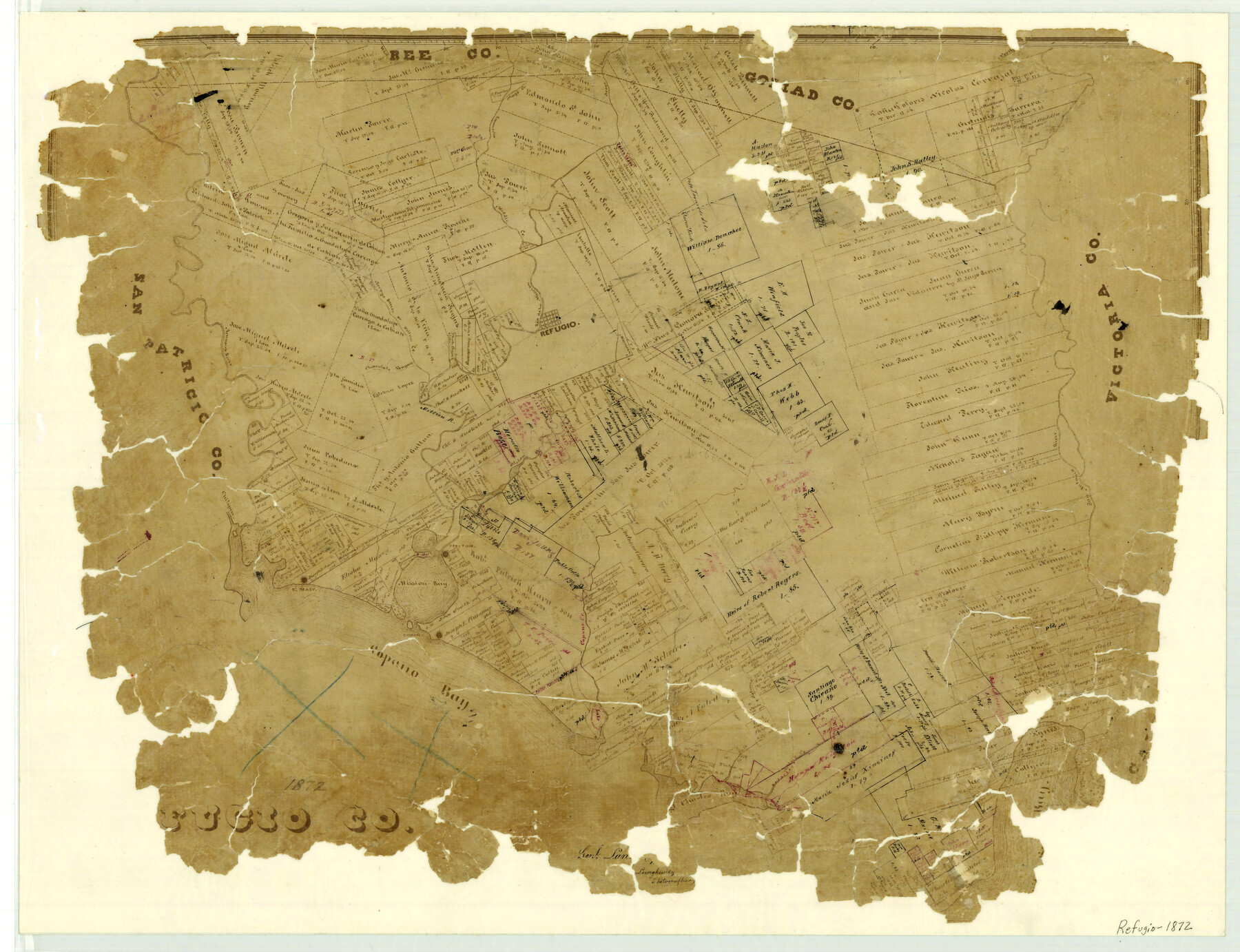
Refugio County
-
Map/Doc
3987
-
Collection
General Map Collection
-
Object Dates
1872 (Creation Date)
-
People and Organizations
Texas General Land Office (Publisher)
Herman Lungkwitz (Draftsman)
-
Counties
Refugio
-
Subjects
County
-
Height x Width
17.6 x 22.9 inches
44.7 x 58.2 cm
-
Features
Mission Bay
Salt Creek
San Antonio River
Rio de la Mission
Burgentine Creek
St. Charles Bay
Hynes Bay
Copano Bay
Salinas Creek
Copano Creek
Copano
Chiltipin
St. Mary
Mays Creek
Preston
Melon Lake
Goose Lake
Mission River
Aransas River
Chocolate Bayou
Willow Creek
Arroyo Sous
Refugio
Middle Creek
Emmedio Creek
Aroyo [sic] Blanco
Part of: General Map Collection
Coleman County Sketch File 16

Print $4.00
- Digital $50.00
Coleman County Sketch File 16
1849
Size 9.6 x 8.3 inches
Map/Doc 18683
Titus County Sketch File 8

Print $4.00
- Digital $50.00
Titus County Sketch File 8
1855
Size 12.7 x 7.9 inches
Map/Doc 38144
Coke County Rolled Sketch 15

Print $40.00
- Digital $50.00
Coke County Rolled Sketch 15
1949
Size 48.1 x 46.5 inches
Map/Doc 8628
Wharton County Working Sketch 10

Print $20.00
- Digital $50.00
Wharton County Working Sketch 10
1980
Size 23.6 x 18.7 inches
Map/Doc 72474
Sutton County Rolled Sketch 67

Print $20.00
- Digital $50.00
Sutton County Rolled Sketch 67
Size 25.4 x 37.3 inches
Map/Doc 7902
Newton County Working Sketch 21

Print $20.00
- Digital $50.00
Newton County Working Sketch 21
1952
Size 27.5 x 32.5 inches
Map/Doc 71267
Starr County Working Sketch 24

Print $20.00
- Digital $50.00
Starr County Working Sketch 24
1988
Size 37.1 x 20.2 inches
Map/Doc 63940
[Missouri, Kansas & Texas Line Map through Bastrop County]
![64031, [Missouri, Kansas & Texas Line Map through Bastrop County], General Map Collection](https://historictexasmaps.com/wmedia_w700/maps/64031.tif.jpg)
Print $40.00
- Digital $50.00
[Missouri, Kansas & Texas Line Map through Bastrop County]
1916
Size 26.5 x 124.4 inches
Map/Doc 64031
Sutton County Sketch File 41

Print $4.00
- Digital $50.00
Sutton County Sketch File 41
1940
Size 14.4 x 8.6 inches
Map/Doc 37507
Sabine River, Watershed of the Sabine and Neches Rivers

Print $20.00
- Digital $50.00
Sabine River, Watershed of the Sabine and Neches Rivers
Size 39.5 x 36.0 inches
Map/Doc 65132

Travis District No. 4 Head of Walnut Creek

Print $2.00
- Digital $50.00
Travis District No. 4 Head of Walnut Creek
1846
Size 4.0 x 8.2 inches
Map/Doc 78382
You may also like
Bowie County Working Sketch 15

Print $20.00
- Digital $50.00
Bowie County Working Sketch 15
1960
Size 34.5 x 25.8 inches
Map/Doc 67419
Hardin County Sketch File 49

Print $4.00
- Digital $50.00
Hardin County Sketch File 49
1904
Size 14.5 x 8.8 inches
Map/Doc 25202
Lamb County Sketch File 2

Print $40.00
- Digital $50.00
Lamb County Sketch File 2
1888
Size 17.1 x 14.4 inches
Map/Doc 29342
Val Verde County Working Sketch 7

Print $20.00
- Digital $50.00
Val Verde County Working Sketch 7
1915
Size 21.9 x 19.5 inches
Map/Doc 72142
Bowie County Working Sketch 3

Print $20.00
- Digital $50.00
Bowie County Working Sketch 3
1913
Size 25.5 x 17.1 inches
Map/Doc 67407
Hudspeth County Sketch File 1

Print $8.00
- Digital $50.00
Hudspeth County Sketch File 1
1900
Size 11.3 x 8.8 inches
Map/Doc 26880
Wise County Working Sketch 31

Print $20.00
- Digital $50.00
Wise County Working Sketch 31
2009
Size 27.9 x 37.5 inches
Map/Doc 89985

Loving County Working Sketch 4

Print $20.00
- Digital $50.00
Loving County Working Sketch 4
1941
Size 20.1 x 40.2 inches
Map/Doc 70636
Garza County Sketch File 1

Print $4.00
- Digital $50.00
Garza County Sketch File 1
1879
Size 9.2 x 8.1 inches
Map/Doc 24044
Eastland County Boundary File 26a

Print $32.00
- Digital $50.00
Eastland County Boundary File 26a
Size 12.7 x 8.1 inches
Map/Doc 52813
Red River, Water-Shed of Cypress Creek in Texas Drainage Area

Print $4.00
- Digital $50.00
Red River, Water-Shed of Cypress Creek in Texas Drainage Area
1925
Size 16.3 x 19.2 inches
Map/Doc 65057