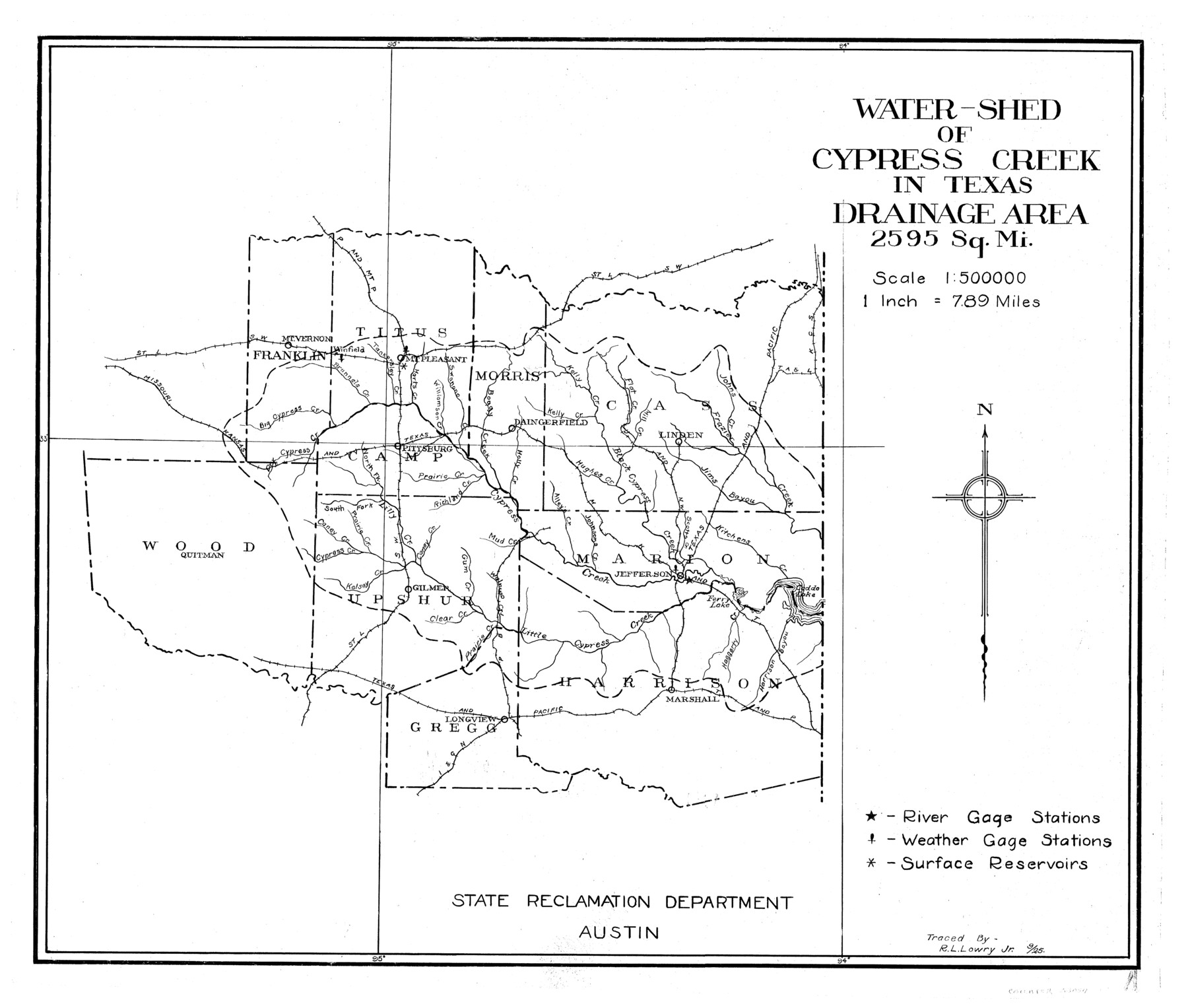
Red River, Water-Shed of Cypress Creek in Texas Drainage Area
-
Map/Doc
65057
-
Collection
General Map Collection
-
Object Dates
1925 (Creation Date)
-
People and Organizations
Texas State Reclamation Department (Publisher)
R.L. Lowry Jr. (Draftsman)
-
Counties
Wood Titus Cass Franklin Morris Camp Upshur
-
Subjects
River Surveys Topographic
-
Height x Width
16.3 x 19.2 inches
41.4 x 48.8 cm
-
Comments
Cypress Creek flows into the Caddo Lake which drains into the Red River in Louisiana.
The following counties are in the watershed of Cypress Creek: Wood, Titus, Cass, Franklin, Morris, Camp, Upshur, Marion, Gregg and Harrison.
Creeks continued: Fl
Part of: General Map Collection
Flight Mission No. CLL-1N, Frame 79, Willacy County

Print $20.00
- Digital $50.00
Flight Mission No. CLL-1N, Frame 79, Willacy County
1954
Size 18.6 x 22.2 inches
Map/Doc 87025
Jeff Davis Co.

Print $20.00
- Digital $50.00
Jeff Davis Co.
1887
Size 37.5 x 47.9 inches
Map/Doc 4991
Travis County Appraisal District Plat Map 2_0605

Print $20.00
- Digital $50.00
Travis County Appraisal District Plat Map 2_0605
Size 21.4 x 26.4 inches
Map/Doc 94240
Current Miscellaneous File 63

Print $6.00
- Digital $50.00
Current Miscellaneous File 63
1957
Size 14.1 x 8.8 inches
Map/Doc 74100
Reeves County Rolled Sketch 27

Print $20.00
- Digital $50.00
Reeves County Rolled Sketch 27
1985
Size 21.6 x 27.6 inches
Map/Doc 7496
Hutchinson County Rolled Sketch 44-1

Print $20.00
- Digital $50.00
Hutchinson County Rolled Sketch 44-1
2002
Size 24.0 x 36.0 inches
Map/Doc 77537
Map of Crockett County

Print $40.00
- Digital $50.00
Map of Crockett County
1878
Size 62.5 x 51.1 inches
Map/Doc 93372
The City of Austin and Suburbs

Print $40.00
- Digital $50.00
The City of Austin and Suburbs
1919
Size 120.7 x 43.9 inches
Map/Doc 88862
Jefferson County Working Sketch 42

Print $20.00
- Digital $50.00
Jefferson County Working Sketch 42
1996
Size 31.7 x 47.2 inches
Map/Doc 66586
Kendall County Boundary File 3a

Print $8.00
- Digital $50.00
Kendall County Boundary File 3a
Size 11.2 x 8.9 inches
Map/Doc 55765
Crosby County Sketch File 11a

Print $10.00
- Digital $50.00
Crosby County Sketch File 11a
1894
Size 8.7 x 4.4 inches
Map/Doc 20029
Right of Way and Track Map, the Missouri, Kansas and Texas Ry. of Texas - Henrietta Division

Print $20.00
- Digital $50.00
Right of Way and Track Map, the Missouri, Kansas and Texas Ry. of Texas - Henrietta Division
1918
Size 11.8 x 26.8 inches
Map/Doc 64751
You may also like
Presidio County Working Sketch Graphic Index, Northeast Part

Print $20.00
- Digital $50.00
Presidio County Working Sketch Graphic Index, Northeast Part
1973
Size 40.3 x 32.2 inches
Map/Doc 76674
[Heirs of Jno. Breeding and surrounding surveys]
![90494, [Heirs of Jno. Breeding and surrounding surveys], Twichell Survey Records](https://historictexasmaps.com/wmedia_w700/maps/90494-1.tif.jpg)
Print $3.00
- Digital $50.00
[Heirs of Jno. Breeding and surrounding surveys]
Size 10.5 x 16.1 inches
Map/Doc 90494
Flight Mission No. DQO-8K, Frame 132, Galveston County

Print $20.00
- Digital $50.00
Flight Mission No. DQO-8K, Frame 132, Galveston County
1952
Size 18.8 x 22.6 inches
Map/Doc 85197
Val Verde County Sketch File A4

Print $10.00
- Digital $50.00
Val Verde County Sketch File A4
1897
Size 9.2 x 8.5 inches
Map/Doc 39046
Crockett County Working Sketch 39

Print $20.00
- Digital $50.00
Crockett County Working Sketch 39
1928
Size 14.7 x 22.2 inches
Map/Doc 68372
Tyler County Sketch File 16

Print $6.00
- Digital $50.00
Tyler County Sketch File 16
1860
Size 9.4 x 11.8 inches
Map/Doc 38661
Cass County Working Sketch 44

Print $20.00
- Digital $50.00
Cass County Working Sketch 44
1989
Size 21.3 x 30.3 inches
Map/Doc 67947
Matagorda County

Print $40.00
- Digital $50.00
Matagorda County
1920
Size 39.7 x 49.1 inches
Map/Doc 77368
Baylor County Rolled Sketch 9A

Print $20.00
- Digital $50.00
Baylor County Rolled Sketch 9A
1892
Size 16.0 x 24.6 inches
Map/Doc 5126
Pecos County Sketch File 104

Print $36.00
- Digital $50.00
Pecos County Sketch File 104
1966
Size 11.3 x 8.7 inches
Map/Doc 34020
Brewster County Working Sketch 44

Print $20.00
- Digital $50.00
Brewster County Working Sketch 44
1947
Size 28.9 x 34.8 inches
Map/Doc 67578
Travis County Working Sketch 35

Print $20.00
- Digital $50.00
Travis County Working Sketch 35
1966
Size 30.4 x 35.5 inches
Map/Doc 69419