Hutchinson County Rolled Sketch 44-1
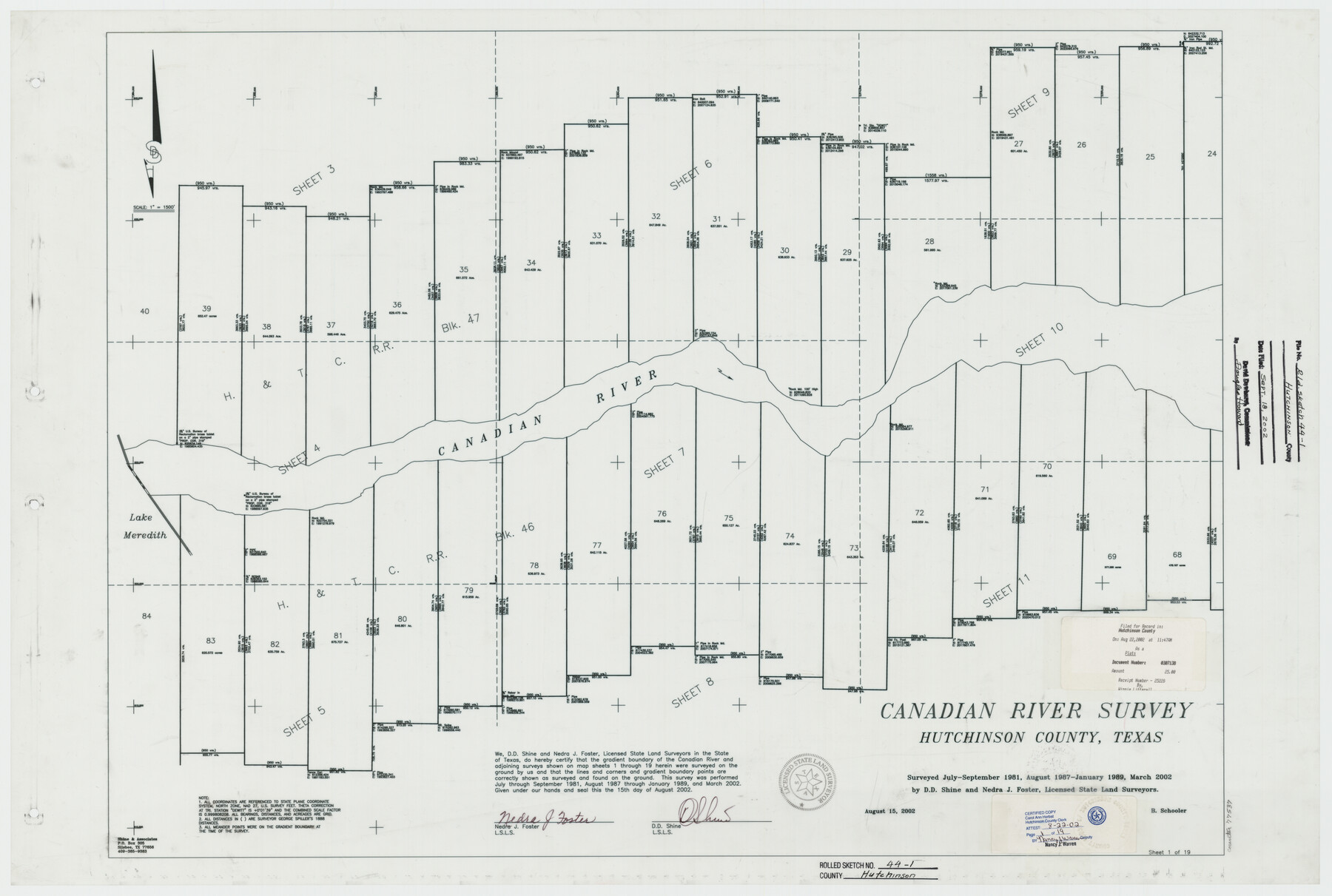
Canadian River Survey, Hutchinson County, Texas [Sheet 1 of 19 - Index Map]
-
Map/Doc
77537
-
Collection
General Map Collection
-
Object Dates
2002/8/15 (Creation Date)
2002/9/18 (File Date)
-
People and Organizations
Nedra J. Foster (Surveyor/Engineer)
D.D. Shine (Surveyor/Engineer)
-
Counties
Hutchinson
-
Subjects
Surveying Rolled Sketch
-
Height x Width
24.0 x 36.0 inches
61.0 x 91.4 cm
-
Medium
mylar, print
-
Scale
1" = 1500 feet
Part of: General Map Collection
Brazos River, Harlem-Imperial Farms Project

Print $4.00
- Digital $50.00
Brazos River, Harlem-Imperial Farms Project
1931
Size 29.4 x 26.6 inches
Map/Doc 65285
Nueces County Sketch File 25a

Print $6.00
- Digital $50.00
Nueces County Sketch File 25a
1890
Size 14.2 x 8.4 inches
Map/Doc 32578
Culberson County Sketch File 7

Print $8.00
- Digital $50.00
Culberson County Sketch File 7
1888
Size 14.5 x 8.8 inches
Map/Doc 20138
Maps of Gulf Intracoastal Waterway, Texas - Sabine River to the Rio Grande and connecting waterways including ship channels

Print $20.00
- Digital $50.00
Maps of Gulf Intracoastal Waterway, Texas - Sabine River to the Rio Grande and connecting waterways including ship channels
1966
Size 14.6 x 22.2 inches
Map/Doc 61945
Bexar County Boundary File 2a

Print $12.00
- Digital $50.00
Bexar County Boundary File 2a
Size 10.0 x 8.1 inches
Map/Doc 50530
Brewster County Rolled Sketch 140

Print $20.00
- Digital $50.00
Brewster County Rolled Sketch 140
1982
Size 36.5 x 25.1 inches
Map/Doc 5308
Located Line of the Panhandle & Gulf Ry. through State Lands

Print $40.00
- Digital $50.00
Located Line of the Panhandle & Gulf Ry. through State Lands
1904
Size 12.4 x 78.0 inches
Map/Doc 64104
Llano County Working Sketch 13

Print $20.00
- Digital $50.00
Llano County Working Sketch 13
1987
Size 23.0 x 22.3 inches
Map/Doc 70631
Swisher County

Print $20.00
- Digital $50.00
Swisher County
1879
Size 21.1 x 18.4 inches
Map/Doc 4064
Runnels County Working Sketch 25

Print $20.00
- Digital $50.00
Runnels County Working Sketch 25
1955
Size 38.2 x 47.1 inches
Map/Doc 63621
Map of the Passo Cavallo

Print $20.00
- Digital $50.00
Map of the Passo Cavallo
1853
Size 18.0 x 27.0 inches
Map/Doc 73011

You may also like
Denton County Boundary File 1

Print $14.00
- Digital $50.00
Denton County Boundary File 1
Size 8.7 x 3.5 inches
Map/Doc 52394
Brazoria County NRC Article 33.136 Sketch 4

Print $22.00
- Digital $50.00
Brazoria County NRC Article 33.136 Sketch 4
2003
Size 24.3 x 35.8 inches
Map/Doc 80120
Val Verde County Working Sketch 88

Print $20.00
- Digital $50.00
Val Verde County Working Sketch 88
1973
Size 29.0 x 36.9 inches
Map/Doc 72223
Cameron County Boundary File 4

Print $42.00
- Digital $50.00
Cameron County Boundary File 4
Size 10.4 x 8.2 inches
Map/Doc 51110
Leon County Working Sketch 51

Print $40.00
- Digital $50.00
Leon County Working Sketch 51
1982
Size 31.5 x 54.6 inches
Map/Doc 70450
[Blocks J, L, and Wilson County School Land]
![91277, [Blocks J, L, and Wilson County School Land], Twichell Survey Records](https://historictexasmaps.com/wmedia_w700/maps/91277-1.tif.jpg)
Print $20.00
- Digital $50.00
[Blocks J, L, and Wilson County School Land]
Size 15.8 x 20.4 inches
Map/Doc 91277
Working Sketch in Stephens County

Print $20.00
- Digital $50.00
Working Sketch in Stephens County
1919
Size 11.1 x 20.6 inches
Map/Doc 91903
Webb County Rolled Sketch 72

Print $20.00
- Digital $50.00
Webb County Rolled Sketch 72
1976
Size 25.5 x 17.5 inches
Map/Doc 8220
[Location Survey of the Southern Kansas Railway, Kiowa Extension from a point in Drake's Location, in Indian Territory 100 miles from south line of Kansas, continuing up Wolf Creek and South Canadian River to Cottonwood Creek in Hutchinson County]
![88844, [Location Survey of the Southern Kansas Railway, Kiowa Extension from a point in Drake's Location, in Indian Territory 100 miles from south line of Kansas, continuing up Wolf Creek and South Canadian River to Cottonwood Creek in Hutchinson County], General Map Collection](https://historictexasmaps.com/wmedia_w700/maps/88844.tif.jpg)
Print $20.00
- Digital $50.00
[Location Survey of the Southern Kansas Railway, Kiowa Extension from a point in Drake's Location, in Indian Territory 100 miles from south line of Kansas, continuing up Wolf Creek and South Canadian River to Cottonwood Creek in Hutchinson County]
1886
Size 39.0 x 40.0 inches
Map/Doc 88844
Kimble County Working Sketch 13

Print $20.00
- Digital $50.00
Kimble County Working Sketch 13
1922
Size 23.8 x 20.8 inches
Map/Doc 70081
Gillespie County Sketch File 7a

Print $4.00
- Digital $50.00
Gillespie County Sketch File 7a
Size 3.5 x 8.1 inches
Map/Doc 24143
[Subdivision of Crockett County School Land Lgs. 214-217]
![90108, [Subdivision of Crockett County School Land Lgs. 214-217], Twichell Survey Records](https://historictexasmaps.com/wmedia_w700/maps/90108-1.tif.jpg)
Print $2.00
- Digital $50.00
[Subdivision of Crockett County School Land Lgs. 214-217]
Size 12.1 x 8.3 inches
Map/Doc 90108