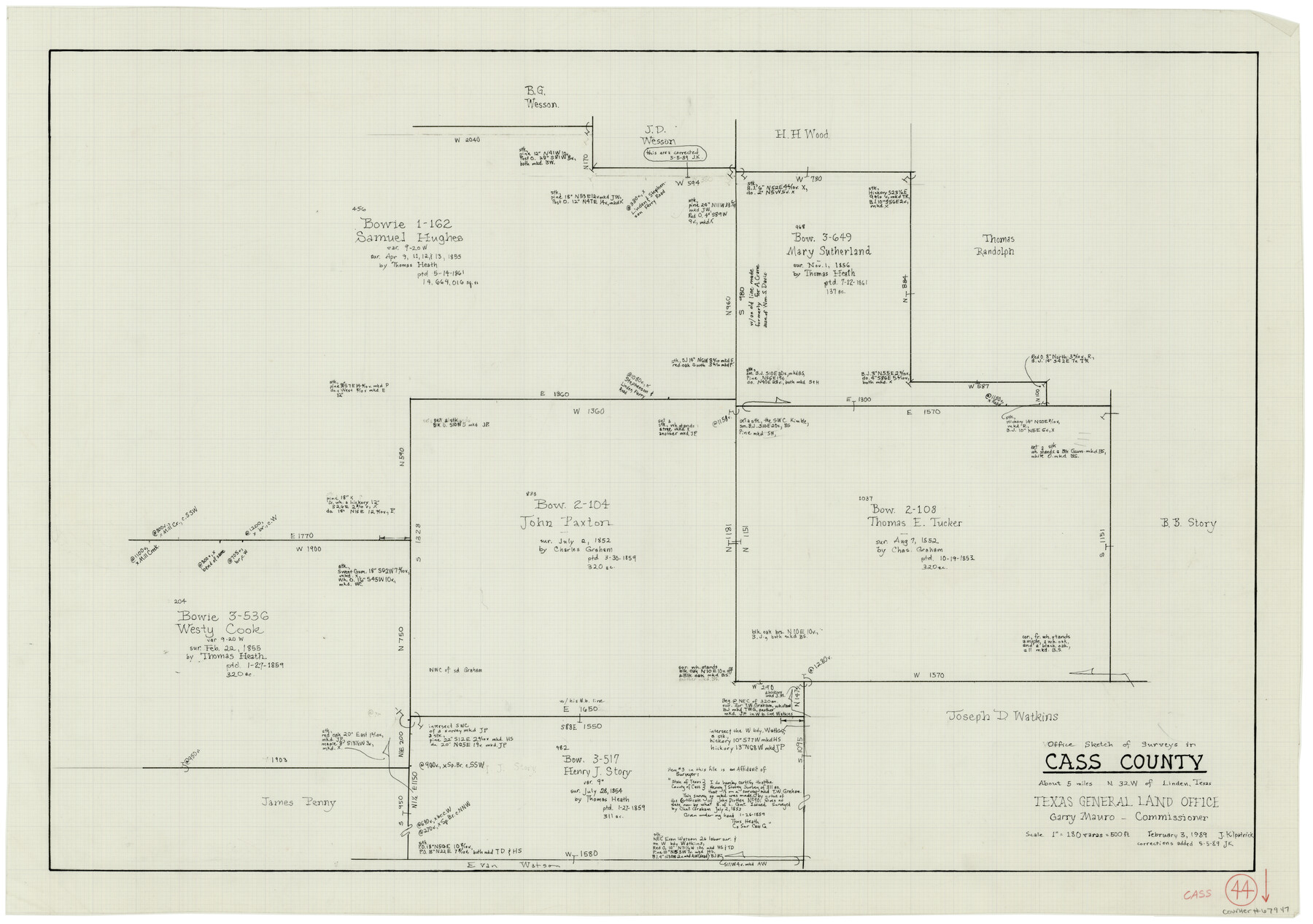
Cass County Working Sketch 44
-
Map/Doc
67947
-
Collection
General Map Collection
-
Object Dates
2/3/1989 (Creation Date)
5/5/1989 (Revision Date)
-
People and Organizations
Joan Kilpatrick (Draftsman)
-
Counties
Cass
-
Subjects
Surveying Working Sketch
-
Height x Width
21.3 x 30.3 inches
54.1 x 77.0 cm
-
Scale
1" = 180 varas
Part of: General Map Collection
Andrews County Working Sketch 1

Print $20.00
- Digital $50.00
Andrews County Working Sketch 1
1946
Size 40.4 x 37.3 inches
Map/Doc 67047

Pecos County Sketch File 101

Print $40.00
- Digital $50.00
Pecos County Sketch File 101
1960
Size 15.6 x 11.7 inches
Map/Doc 34012
Milam County Boundary File 3

Print $16.00
- Digital $50.00
Milam County Boundary File 3
Size 13.9 x 8.5 inches
Map/Doc 57213
Travis County Appraisal District Plat Map 2_0605

Print $20.00
- Digital $50.00
Travis County Appraisal District Plat Map 2_0605
Size 21.4 x 26.4 inches
Map/Doc 94240
Flight Mission No. CGI-3N, Frame 158, Cameron County

Print $20.00
- Digital $50.00
Flight Mission No. CGI-3N, Frame 158, Cameron County
1954
Size 18.5 x 22.4 inches
Map/Doc 84622
Shelby County Rolled Sketch 9

Print $20.00
- Digital $50.00
Shelby County Rolled Sketch 9
Size 23.0 x 19.1 inches
Map/Doc 7777
Wichita County Working Sketch 29

Print $20.00
- Digital $50.00
Wichita County Working Sketch 29
2014
Size 16.7 x 20.0 inches
Map/Doc 93688
Runnels County Sketch File 25

Print $20.00
Runnels County Sketch File 25
1940
Size 16.5 x 16.7 inches
Map/Doc 12259
Fannin County Sketch File 15

Print $6.00
- Digital $50.00
Fannin County Sketch File 15
1866
Size 8.2 x 8.2 inches
Map/Doc 22466
Stephens County Working Sketch 39

Print $20.00
- Digital $50.00
Stephens County Working Sketch 39
1995
Size 25.5 x 27.1 inches
Map/Doc 63982
Hudspeth County Sketch File 4b

Print $20.00
- Digital $50.00
Hudspeth County Sketch File 4b
1860
Size 13.0 x 39.2 inches
Map/Doc 10492
You may also like
Andrews County Working Sketch 9

Print $20.00
- Digital $50.00
Andrews County Working Sketch 9
1955
Size 10.2 x 23.3 inches
Map/Doc 67055
Jefferson County Sketch File 47

Print $20.00
- Digital $50.00
Jefferson County Sketch File 47
1898
Size 27.2 x 19.1 inches
Map/Doc 11881
Mitchell County Sketch File 16b

Print $20.00
- Digital $50.00
Mitchell County Sketch File 16b
Size 28.7 x 36.8 inches
Map/Doc 10545
Palo Pinto County Sketch File 2

Print $4.00
- Digital $50.00
Palo Pinto County Sketch File 2
1857
Size 8.2 x 10.3 inches
Map/Doc 33392
Map of Public Land on Mustang Island

Print $20.00
- Digital $50.00
Map of Public Land on Mustang Island
Size 21.9 x 17.5 inches
Map/Doc 82315
Map of South Pacific Rail Road Co. of Missouri.

Print $20.00
Map of South Pacific Rail Road Co. of Missouri.
1870
Size 13.4 x 15.7 inches
Map/Doc 93613
Comal County Working Sketch 13

Print $20.00
- Digital $50.00
Comal County Working Sketch 13
1988
Size 32.6 x 21.3 inches
Map/Doc 68179
Brewster County Working Sketch 115

Print $40.00
- Digital $50.00
Brewster County Working Sketch 115
1985
Size 49.6 x 43.4 inches
Map/Doc 67715
Starr County Sketch File 20a

Print $12.00
- Digital $50.00
Starr County Sketch File 20a
1892
Size 14.3 x 8.8 inches
Map/Doc 36883
Little River, Widths of Floodways

Print $6.00
- Digital $50.00
Little River, Widths of Floodways
1921
Size 23.2 x 34.9 inches
Map/Doc 65070
[Surveys in Polk and Tyler Counties, Liberty District]
![354, [Surveys in Polk and Tyler Counties, Liberty District], General Map Collection](https://historictexasmaps.com/wmedia_w700/maps/354.tif.jpg)
Print $2.00
- Digital $50.00
[Surveys in Polk and Tyler Counties, Liberty District]
1847
Size 10.8 x 8.1 inches
Map/Doc 354
Wood County Boundary File 4

Print $6.00
- Digital $50.00
Wood County Boundary File 4
Size 12.1 x 8.1 inches
Map/Doc 60167