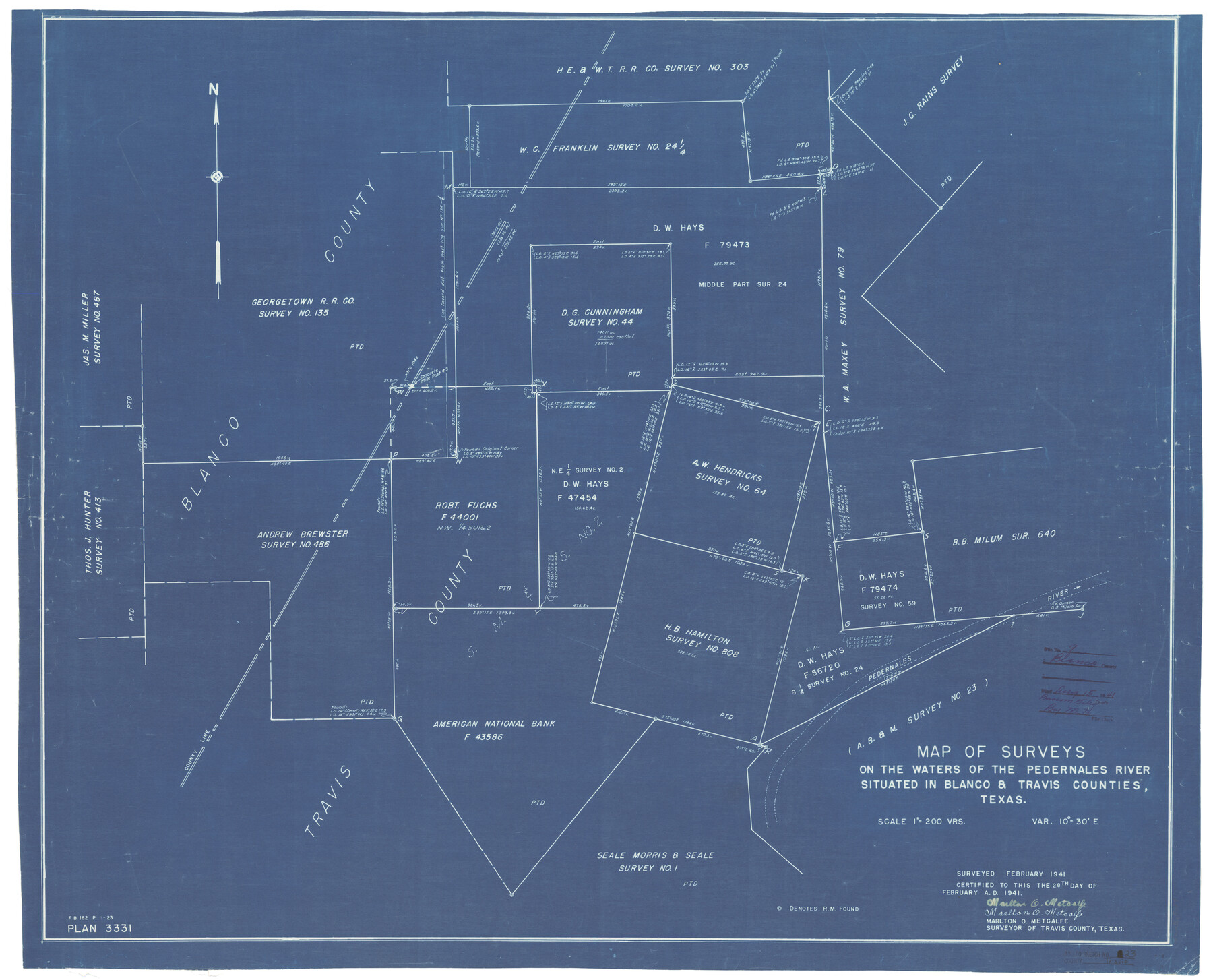
Travis County Rolled Sketch 23
Map of surveys on the waters of the Pedernales River situated in Blanco & Travis Counties, Texas
-
Map/Doc
8024
-
Collection
General Map Collection
-
Object Dates
1941 (Survey Date)
1941/8/15 (File Date)
1941/2/28 (Creation Date)
-
People and Organizations
Marlton O. Metcalfe (Surveyor/Engineer)
-
Counties
Travis Blanco
-
Subjects
Surveying Rolled Sketch
-
Height x Width
30.5 x 37.7 inches
77.5 x 95.8 cm
-
Medium
blueprint/diazo
-
Scale
1" = 200 varas
Part of: General Map Collection
Coke County Sketch File 6

Print $6.00
- Digital $50.00
Coke County Sketch File 6
1860
Size 7.5 x 10.0 inches
Map/Doc 18582
Flight Mission No. DCL-6C, Frame 2, Kenedy County

Print $20.00
- Digital $50.00
Flight Mission No. DCL-6C, Frame 2, Kenedy County
1943
Size 18.6 x 22.4 inches
Map/Doc 85862
Flight Mission No. CUG-1P, Frame 166, Kleberg County

Print $20.00
- Digital $50.00
Flight Mission No. CUG-1P, Frame 166, Kleberg County
1956
Size 18.8 x 22.4 inches
Map/Doc 86173
Callahan County Sketch File 15

Print $16.00
- Digital $50.00
Callahan County Sketch File 15
1944
Size 11.2 x 8.8 inches
Map/Doc 35890
Concho County Sketch File 47

Print $20.00
- Digital $50.00
Concho County Sketch File 47
1950
Size 16.8 x 21.0 inches
Map/Doc 11165
Presidio County Working Sketch 56

Print $20.00
- Digital $50.00
Presidio County Working Sketch 56
1955
Size 13.9 x 22.0 inches
Map/Doc 71733

Chambers County Sketch File 32

Print $8.00
- Digital $50.00
Chambers County Sketch File 32
1900
Size 7.1 x 10.6 inches
Map/Doc 17616
Sterling County Rolled Sketch 36

Print $20.00
- Digital $50.00
Sterling County Rolled Sketch 36
Size 24.2 x 38.0 inches
Map/Doc 7860
Flight Mission No. DAG-24K, Frame 38, Matagorda County

Print $20.00
- Digital $50.00
Flight Mission No. DAG-24K, Frame 38, Matagorda County
1953
Size 18.5 x 15.8 inches
Map/Doc 86525
Flight Mission No. DQN-5K, Frame 82, Calhoun County

Print $20.00
- Digital $50.00
Flight Mission No. DQN-5K, Frame 82, Calhoun County
1953
Size 18.5 x 22.1 inches
Map/Doc 84415
Cottle County Working Sketch 18

Print $20.00
- Digital $50.00
Cottle County Working Sketch 18
1977
Size 32.2 x 41.3 inches
Map/Doc 68328
You may also like
Lampasas County Sketch File 5

Print $8.00
- Digital $50.00
Lampasas County Sketch File 5
1869
Size 12.8 x 7.9 inches
Map/Doc 29396
Robertson County Working Sketch 1

Print $20.00
- Digital $50.00
Robertson County Working Sketch 1
1923
Size 26.2 x 36.6 inches
Map/Doc 63574
J.H. Clark's Report of 1861 - Boundary Between Texas and New Mexico

Print $78.00
J.H. Clark's Report of 1861 - Boundary Between Texas and New Mexico
1861
Map/Doc 81689
[PSL Blocks A57, 77; B1-B3, T. & P. Block 46, T-1-N]
![90167, [PSL Blocks A57, 77; B1-B3, T. & P. Block 46, T-1-N], Twichell Survey Records](https://historictexasmaps.com/wmedia_w700/maps/90167-1.tif.jpg)
Print $20.00
- Digital $50.00
[PSL Blocks A57, 77; B1-B3, T. & P. Block 46, T-1-N]
Size 33.4 x 36.1 inches
Map/Doc 90167
Edwards County Rolled Sketch 27

Print $20.00
- Digital $50.00
Edwards County Rolled Sketch 27
1959
Size 18.0 x 33.2 inches
Map/Doc 5813
The Judicial District/County of Madison. Abolished, Spring 1842

Print $20.00
The Judicial District/County of Madison. Abolished, Spring 1842
2020
Size 18.2 x 21.7 inches
Map/Doc 96334
Pecos County Rolled Sketch 142

Print $20.00
- Digital $50.00
Pecos County Rolled Sketch 142
Size 26.9 x 41.9 inches
Map/Doc 7276
Cooke County Boundary File 1b

Print $28.00
- Digital $50.00
Cooke County Boundary File 1b
Size 12.6 x 7.4 inches
Map/Doc 51835
Jack County Rolled Sketch 3

Print $20.00
- Digital $50.00
Jack County Rolled Sketch 3
1985
Size 30.3 x 27.5 inches
Map/Doc 6333
Pecos County Working Sketch Graphic Index - northeast part - sheet A

Print $20.00
- Digital $50.00
Pecos County Working Sketch Graphic Index - northeast part - sheet A
1975
Size 35.8 x 42.6 inches
Map/Doc 76666
Cherokee County Working Sketch 13

Print $20.00
- Digital $50.00
Cherokee County Working Sketch 13
1957
Size 46.5 x 43.8 inches
Map/Doc 67968
Texas Coordinate File 3

Print $40.00
- Digital $50.00
Texas Coordinate File 3
Size 36.1 x 49.1 inches
Map/Doc 75306