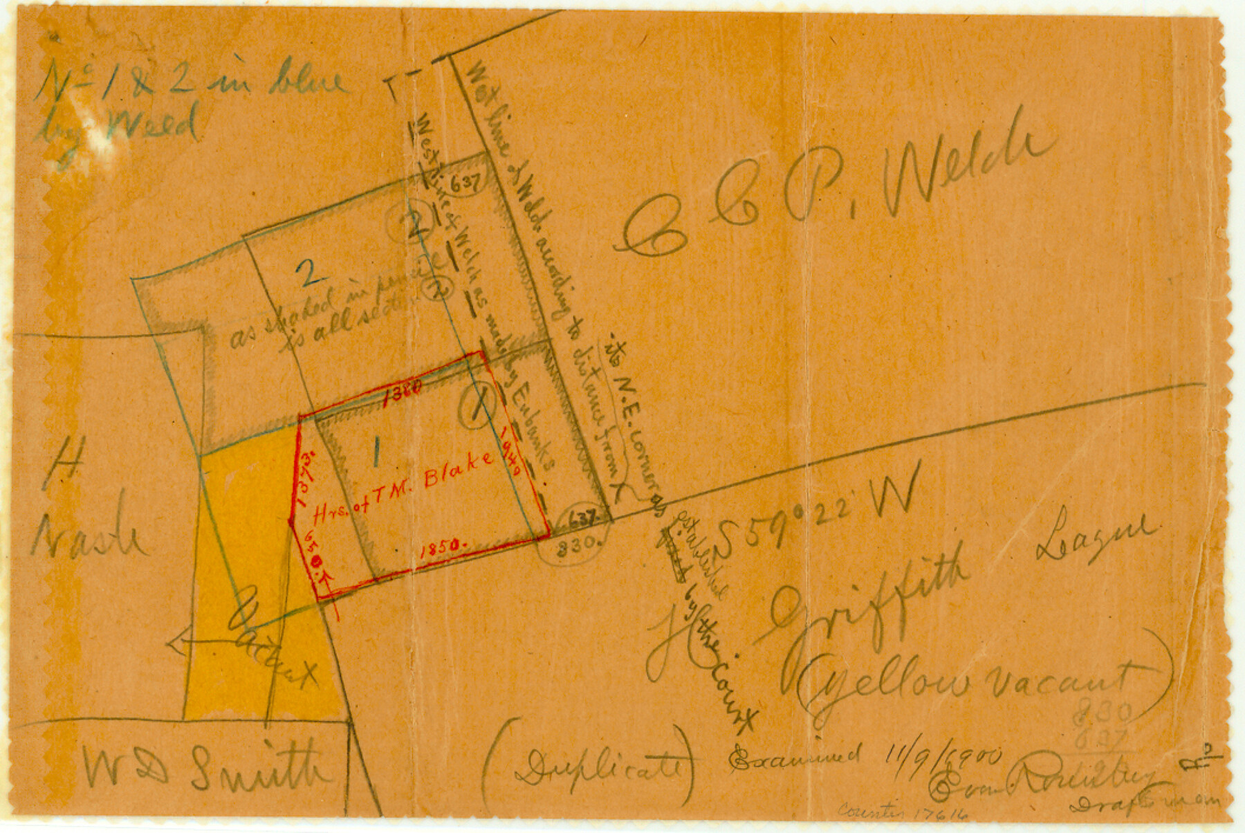
Chambers County Sketch File 32
[Sketches of area in the northwest corner of county around the Welch and Griffith surveys]
-
Map/Doc
17616
-
Collection
General Map Collection
-
Object Dates
1900/11/6 (Creation Date)
-
People and Organizations
Geo. Giddings (Surveyor/Engineer)
-
Counties
Chambers
-
Subjects
Surveying Sketch File
-
Height x Width
7.1 x 10.6 inches
18.0 x 26.9 cm
-
Medium
paper, manuscript
Part of: General Map Collection
Brewster County Rolled Sketch 143

Print $20.00
- Digital $50.00
Brewster County Rolled Sketch 143
1985
Size 18.3 x 28.0 inches
Map/Doc 5311
Kimble County Rolled Sketch 37

Print $20.00
- Digital $50.00
Kimble County Rolled Sketch 37
1982
Size 21.6 x 28.0 inches
Map/Doc 6527
Victoria County Sketch File 1

Print $20.00
- Digital $50.00
Victoria County Sketch File 1
1853
Size 12.9 x 17.3 inches
Map/Doc 12595
Limestone County

Print $40.00
- Digital $50.00
Limestone County
1922
Size 48.1 x 35.4 inches
Map/Doc 16880
Clay County Sketch File 1

Print $22.00
- Digital $50.00
Clay County Sketch File 1
1855
Size 8.9 x 7.6 inches
Map/Doc 18386
La Salle County Rolled Sketch 21

Print $77.00
- Digital $50.00
La Salle County Rolled Sketch 21
1955
Size 10.0 x 15.1 inches
Map/Doc 46461
Pecos County Rolled Sketch 20

Print $20.00
- Digital $50.00
Pecos County Rolled Sketch 20
Size 31.8 x 29.1 inches
Map/Doc 9685
Map of Burnet County

Print $20.00
- Digital $50.00
Map of Burnet County
1862
Size 27.1 x 22.5 inches
Map/Doc 3353
Harris County Working Sketch 67

Print $20.00
- Digital $50.00
Harris County Working Sketch 67
1955
Size 23.3 x 27.5 inches
Map/Doc 65959
Padre Island Under Six Flags

Print $40.00
- Digital $50.00
Padre Island Under Six Flags
1962
Size 63.7 x 36.9 inches
Map/Doc 3126
Controlled Mosaic by Jack Amman Photogrammetric Engineers, Inc - Sheet 30

Print $20.00
- Digital $50.00
Controlled Mosaic by Jack Amman Photogrammetric Engineers, Inc - Sheet 30
1954
Size 20.0 x 24.0 inches
Map/Doc 83483
Flight Mission No. BRA-7M, Frame 43, Jefferson County

Print $20.00
- Digital $50.00
Flight Mission No. BRA-7M, Frame 43, Jefferson County
1953
Size 18.6 x 22.4 inches
Map/Doc 85494
You may also like
Coleman County Sketch File 27a

Print $20.00
- Digital $50.00
Coleman County Sketch File 27a
Size 22.6 x 24.3 inches
Map/Doc 11121
Township 8 South Range 13 West, South Western District, Louisiana

Print $20.00
- Digital $50.00
Township 8 South Range 13 West, South Western District, Louisiana
1879
Size 19.5 x 24.8 inches
Map/Doc 65888
[Maps of surveys in Reeves & Culberson Cos]
![61147, [Maps of surveys in Reeves & Culberson Cos], General Map Collection](https://historictexasmaps.com/wmedia_w700/maps/61147.tif.jpg)
Print $20.00
- Digital $50.00
[Maps of surveys in Reeves & Culberson Cos]
1937
Size 30.6 x 24.9 inches
Map/Doc 61147
Henderson County Rolled Sketch 2

Print $20.00
- Digital $50.00
Henderson County Rolled Sketch 2
1956
Size 33.7 x 26.5 inches
Map/Doc 9160
Located Line of the Panhandle & Gulf Ry. through State Lands, Public School and University, in Reagan County, Texas, Right of Way 200 feet wide

Print $40.00
- Digital $50.00
Located Line of the Panhandle & Gulf Ry. through State Lands, Public School and University, in Reagan County, Texas, Right of Way 200 feet wide
1904
Size 13.4 x 90.8 inches
Map/Doc 64063
Fort Bend County Working Sketch 16

Print $20.00
- Digital $50.00
Fort Bend County Working Sketch 16
1953
Size 42.4 x 46.0 inches
Map/Doc 69222
Hudspeth County Sketch File 39

Print $42.00
- Digital $50.00
Hudspeth County Sketch File 39
Size 8.8 x 11.5 inches
Map/Doc 27010
Castro County Rolled Sketch 14

Print $20.00
- Digital $50.00
Castro County Rolled Sketch 14
1965
Size 47.6 x 43.5 inches
Map/Doc 8608
DeWitt County Sketch File 4

Print $4.00
- Digital $50.00
DeWitt County Sketch File 4
1872
Size 8.3 x 13.1 inches
Map/Doc 20801
Leon County Sketch File 26

Print $20.00
- Digital $50.00
Leon County Sketch File 26
1948
Size 11.4 x 8.6 inches
Map/Doc 29801
Wilbarger County Aerial Photograph Index Sheet 4

Print $20.00
- Digital $50.00
Wilbarger County Aerial Photograph Index Sheet 4
1950
Size 21.7 x 18.8 inches
Map/Doc 83753
Real County Working Sketch 34

Print $20.00
- Digital $50.00
Real County Working Sketch 34
1948
Size 25.6 x 29.0 inches
Map/Doc 71926