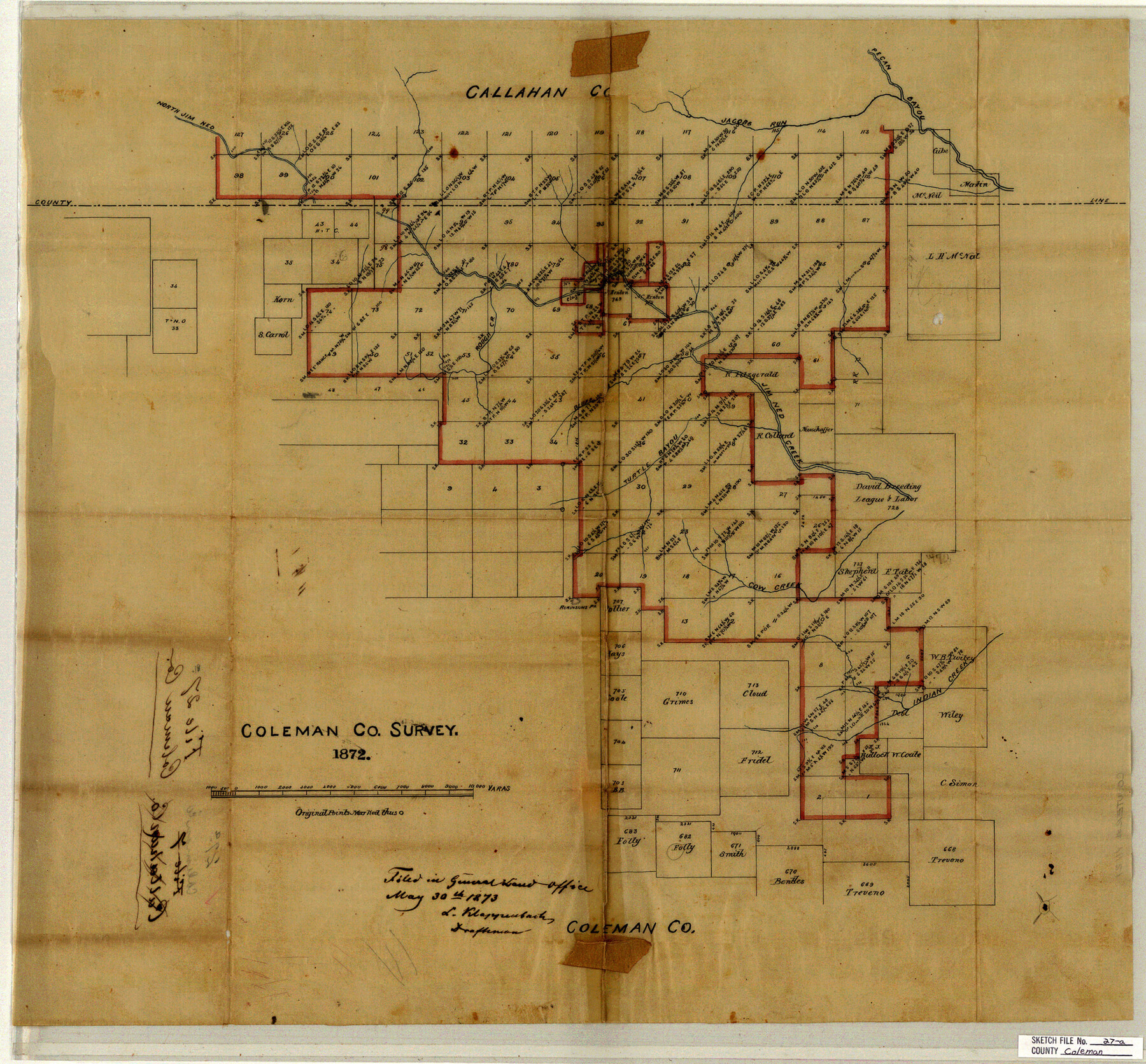
Coleman County Sketch File 27a
[Sketch of G. H. & H. R.R. Co. Block 2 and surrounding areas in north part of Coleman County and south part of Callahan County]
-
Map/Doc
11121
-
Collection
General Map Collection
-
Object Dates
1873/5/30 (File Date)
-
Counties
Coleman Callahan
-
Subjects
Surveying Sketch File
-
Height x Width
22.6 x 24.3 inches
57.4 x 61.7 cm
-
Medium
paper, manuscript
-
Features
North Jim Ned Creek
Jacobs Run
Pecan Bayou
Rough Creek
Bluff Creek
Jim Ned Creek
Cow Creek
Robinson's Peak
Turtle Bayou
Indian Creek
Part of: General Map Collection
Childress County Sketch File 23

Print $4.00
- Digital $50.00
Childress County Sketch File 23
1892
Size 10.9 x 8.7 inches
Map/Doc 18382
Map of the River Sabine from its mouth on the Gulf of Mexico in the Sea to Logan's Ferry in Latitude 31°58'24" North

Print $20.00
- Digital $50.00
Map of the River Sabine from its mouth on the Gulf of Mexico in the Sea to Logan's Ferry in Latitude 31°58'24" North
1842
Size 47.9 x 30.6 inches
Map/Doc 87150
Knox County Sketch File 8

Print $26.00
- Digital $50.00
Knox County Sketch File 8
1882
Size 8.6 x 7.8 inches
Map/Doc 29218
Flight Mission No. DQO-8K, Frame 53, Galveston County

Print $20.00
- Digital $50.00
Flight Mission No. DQO-8K, Frame 53, Galveston County
1952
Size 18.6 x 22.3 inches
Map/Doc 85160
Harris County Rolled Sketch 77

Print $20.00
- Digital $50.00
Harris County Rolled Sketch 77
1914
Size 30.0 x 35.6 inches
Map/Doc 6114
Montgomery County Sketch File 4

Print $8.00
- Digital $50.00
Montgomery County Sketch File 4
1854
Size 12.0 x 8.1 inches
Map/Doc 31775
Wood County Boundary File 97

Print $2.00
- Digital $50.00
Wood County Boundary File 97
Size 9.4 x 4.5 inches
Map/Doc 60195
Gonzales County Working Sketch 11
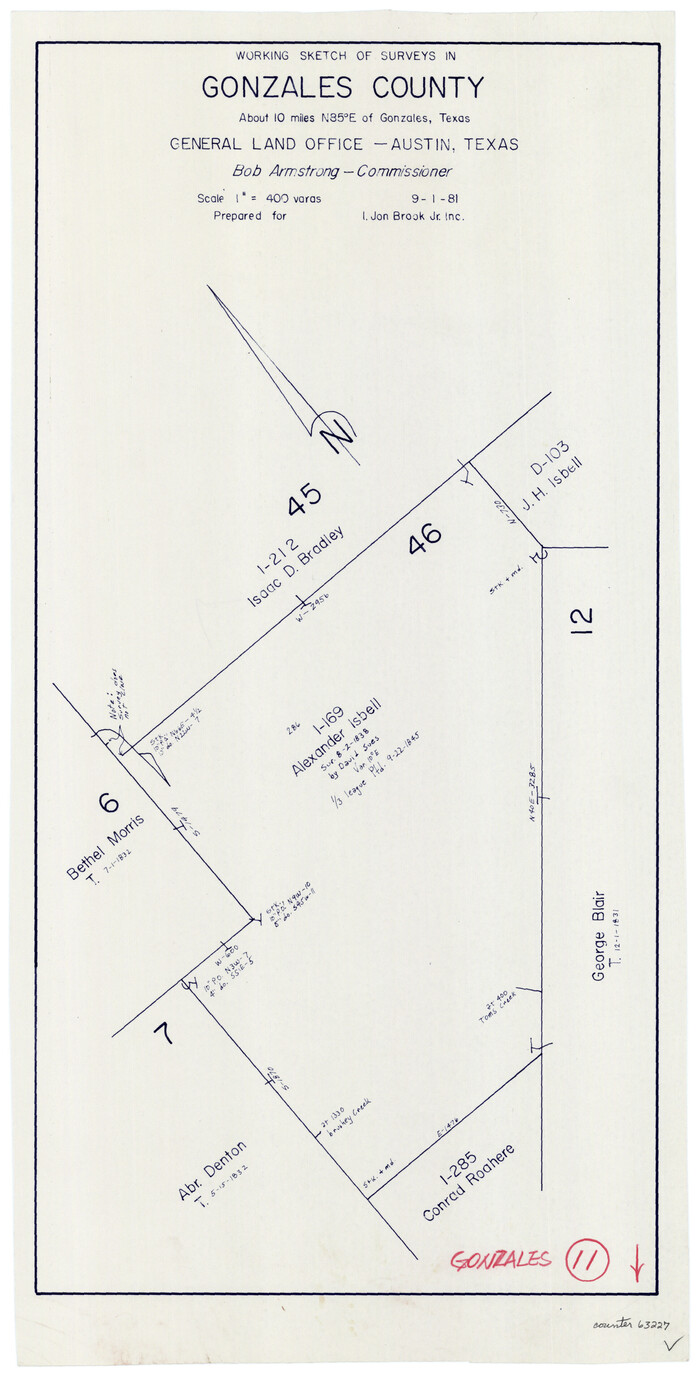
Print $20.00
- Digital $50.00
Gonzales County Working Sketch 11
1981
Size 22.2 x 11.3 inches
Map/Doc 63227
Laguna Madre, Texas from Latitude 26° 20' to 26° 27'

Print $40.00
- Digital $50.00
Laguna Madre, Texas from Latitude 26° 20' to 26° 27'
1879
Size 32.7 x 55.0 inches
Map/Doc 73498
Pecos County Rolled Sketch 132

Print $20.00
- Digital $50.00
Pecos County Rolled Sketch 132
Size 32.8 x 38.9 inches
Map/Doc 9728

Hamilton County Working Sketch 35

Print $20.00
- Digital $50.00
Hamilton County Working Sketch 35
Size 26.3 x 19.1 inches
Map/Doc 78286
You may also like
Sutton County Working Sketch 54

Print $20.00
- Digital $50.00
Sutton County Working Sketch 54
1957
Size 28.0 x 38.4 inches
Map/Doc 62397
Chambers County Sketch File 4b

Print $27.00
- Digital $50.00
Chambers County Sketch File 4b
1950
Size 8.6 x 14.2 inches
Map/Doc 17530
Grayson County

Print $20.00
- Digital $50.00
Grayson County
1935
Size 43.3 x 39.9 inches
Map/Doc 77294
[Beaty and Moulton Block A, Southern Pacific Railroad Block 2]
![91398, [Beaty and Moulton Block A, Southern Pacific Railroad Block 2], Twichell Survey Records](https://historictexasmaps.com/wmedia_w700/maps/91398-1.tif.jpg)
Print $20.00
- Digital $50.00
[Beaty and Moulton Block A, Southern Pacific Railroad Block 2]
1914
Size 24.2 x 15.4 inches
Map/Doc 91398
Leon County Working Sketch 11

Print $20.00
- Digital $50.00
Leon County Working Sketch 11
1952
Size 21.1 x 35.0 inches
Map/Doc 70410
Tarrant County

Print $40.00
- Digital $50.00
Tarrant County
1942
Size 48.6 x 37.8 inches
Map/Doc 73298
Austin County Rolled Sketch 6

Print $20.00
- Digital $50.00
Austin County Rolled Sketch 6
1951
Size 25.5 x 34.0 inches
Map/Doc 5108
Texas-Oklahoma (Indian Territory) Montague Quadrangle

Print $20.00
- Digital $50.00
Texas-Oklahoma (Indian Territory) Montague Quadrangle
1905
Size 20.4 x 17.0 inches
Map/Doc 75106
Flight Mission No. DQN-5K, Frame 46, Calhoun County

Print $20.00
- Digital $50.00
Flight Mission No. DQN-5K, Frame 46, Calhoun County
1953
Size 18.6 x 22.2 inches
Map/Doc 84391
Gregg County Rolled Sketch 7

Print $20.00
- Digital $50.00
Gregg County Rolled Sketch 7
1933
Size 24.6 x 42.0 inches
Map/Doc 6032
Carson County Sketch File 7

Print $20.00
- Digital $50.00
Carson County Sketch File 7
Size 26.7 x 15.0 inches
Map/Doc 11056
Loving County Rolled Sketch 15

Print $20.00
- Digital $50.00
Loving County Rolled Sketch 15
2015
Size 36.2 x 24.4 inches
Map/Doc 93793