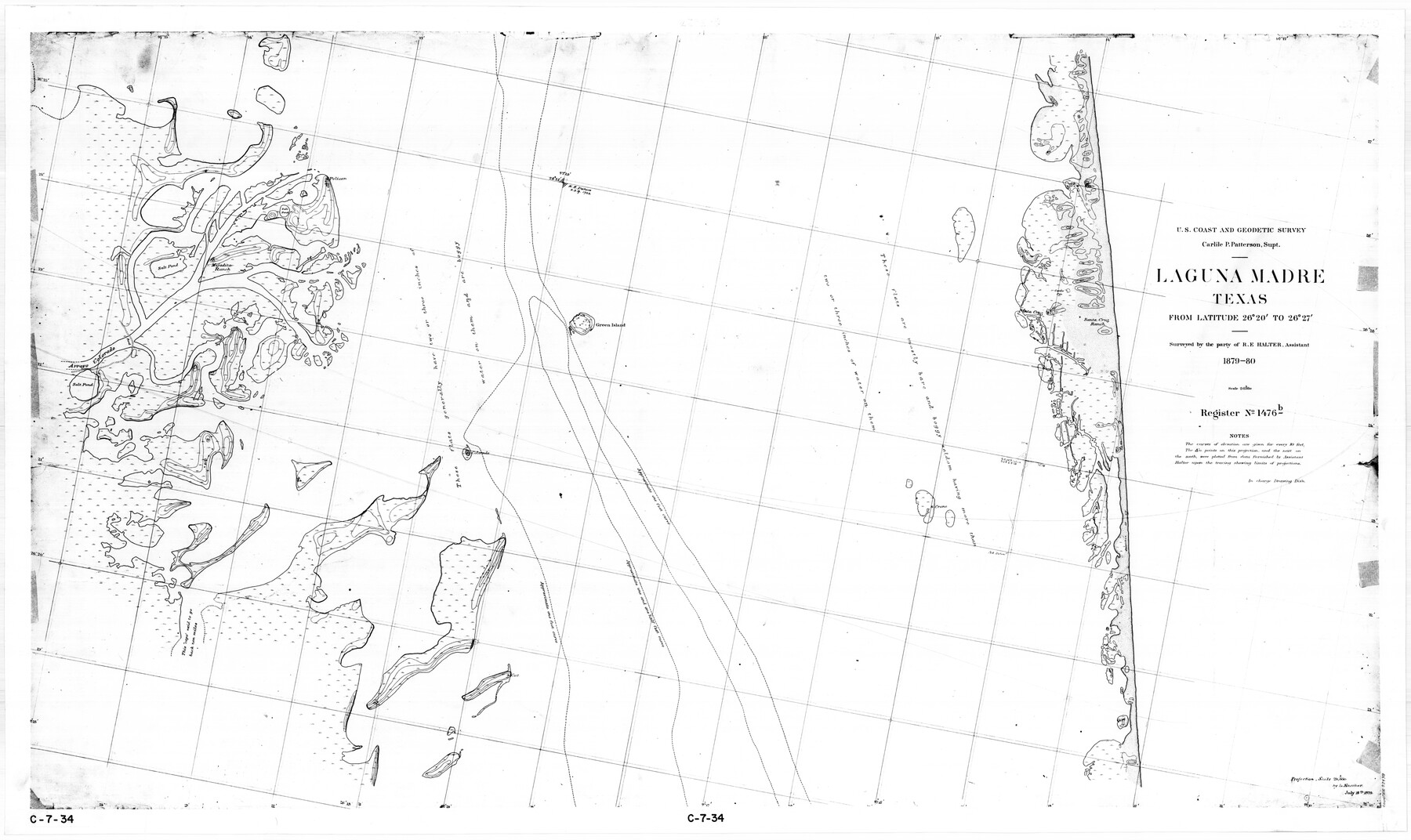
Laguna Madre, Texas from Latitude 26° 20' to 26° 27'
C-7-34
-
Map/Doc
73498
-
Collection
General Map Collection
-
Object Dates
1879 (Creation Date)
-
Counties
Willacy Cameron
-
Subjects
Nautical Charts
-
Height x Width
32.7 x 55.0 inches
83.1 x 139.7 cm
-
Comments
Register No. 1476b
Part of: General Map Collection
Wood County Working Sketch 8

Print $20.00
- Digital $50.00
Wood County Working Sketch 8
1943
Size 27.7 x 25.2 inches
Map/Doc 62008
Calhoun County Sketch File 18

Print $61.00
- Digital $50.00
Calhoun County Sketch File 18
1990
Size 11.2 x 8.7 inches
Map/Doc 35986
Webb County Rolled Sketch 61

Print $20.00
- Digital $50.00
Webb County Rolled Sketch 61
1947
Size 38.6 x 36.5 inches
Map/Doc 10128
Flight Mission No. DQO-2K, Frame 151, Galveston County

Print $20.00
- Digital $50.00
Flight Mission No. DQO-2K, Frame 151, Galveston County
1952
Size 18.9 x 22.6 inches
Map/Doc 85048
Nueces County Rolled Sketch 100

Print $20.00
- Digital $50.00
Nueces County Rolled Sketch 100
1938
Size 37.2 x 25.2 inches
Map/Doc 9634
Trinity County Working Sketch 22

Print $40.00
- Digital $50.00
Trinity County Working Sketch 22
2009
Size 32.0 x 52.1 inches
Map/Doc 89068
Gaines County Working Sketch 27

Print $20.00
- Digital $50.00
Gaines County Working Sketch 27
Size 17.4 x 36.7 inches
Map/Doc 69327
Flight Mission No. DAH-9M, Frame 84, Orange County

Print $20.00
- Digital $50.00
Flight Mission No. DAH-9M, Frame 84, Orange County
1953
Size 18.7 x 22.5 inches
Map/Doc 86848
Stephens County Sketch File 25

Print $35.00
- Digital $50.00
Stephens County Sketch File 25
1875
Size 11.0 x 15.9 inches
Map/Doc 37090
Fractional Township No. 7 South Range No. 7 East of the Indian Meridian, Indian Territory

Print $20.00
- Digital $50.00
Fractional Township No. 7 South Range No. 7 East of the Indian Meridian, Indian Territory
1898
Size 19.2 x 24.3 inches
Map/Doc 75212
Flight Mission No. BQR-13K, Frame 116, Brazoria County

Print $20.00
- Digital $50.00
Flight Mission No. BQR-13K, Frame 116, Brazoria County
1952
Size 18.7 x 22.4 inches
Map/Doc 84077
Montgomery County Rolled Sketch 26

Print $40.00
- Digital $50.00
Montgomery County Rolled Sketch 26
Size 50.0 x 65.4 inches
Map/Doc 9535
You may also like
Guadalupe County Working Sketch 9

Print $20.00
- Digital $50.00
Guadalupe County Working Sketch 9
1955
Size 21.9 x 12.6 inches
Map/Doc 63318
Rand, McNally & Co.'s Texas

Print $20.00
- Digital $50.00
Rand, McNally & Co.'s Texas
1895
Size 21.2 x 28.6 inches
Map/Doc 95885

![91465, [Block B7], Twichell Survey Records](https://historictexasmaps.com/wmedia_w700/maps/91465-1.tif.jpg)
[Strickland Survey Sketch Showing Abercrombie Corner, Exhibit C]
![91369, [Strickland Survey Sketch Showing Abercrombie Corner, Exhibit C], Twichell Survey Records](https://historictexasmaps.com/wmedia_w700/maps/91369-1.tif.jpg)
Print $20.00
- Digital $50.00
[Strickland Survey Sketch Showing Abercrombie Corner, Exhibit C]
Size 18.0 x 24.5 inches
Map/Doc 91369
Southern Part of Laguna Madre

Print $20.00
- Digital $50.00
Southern Part of Laguna Madre
1966
Size 44.3 x 34.8 inches
Map/Doc 73540
Guadalupe County Sketch File 12

Print $8.00
- Digital $50.00
Guadalupe County Sketch File 12
1869
Size 12.9 x 8.2 inches
Map/Doc 24683
General Highway Map, Henderson County, Texas

Print $20.00
General Highway Map, Henderson County, Texas
1961
Size 24.8 x 18.2 inches
Map/Doc 79516
Wheeler County

Print $20.00
- Digital $50.00
Wheeler County
1932
Size 41.7 x 38.0 inches
Map/Doc 73322
Starr County Working Sketch 27

Print $20.00
- Digital $50.00
Starr County Working Sketch 27
1994
Size 29.6 x 30.3 inches
Map/Doc 63943
Loving County Rolled Sketch 1A

Print $40.00
- Digital $50.00
Loving County Rolled Sketch 1A
Size 77.9 x 42.9 inches
Map/Doc 9461
