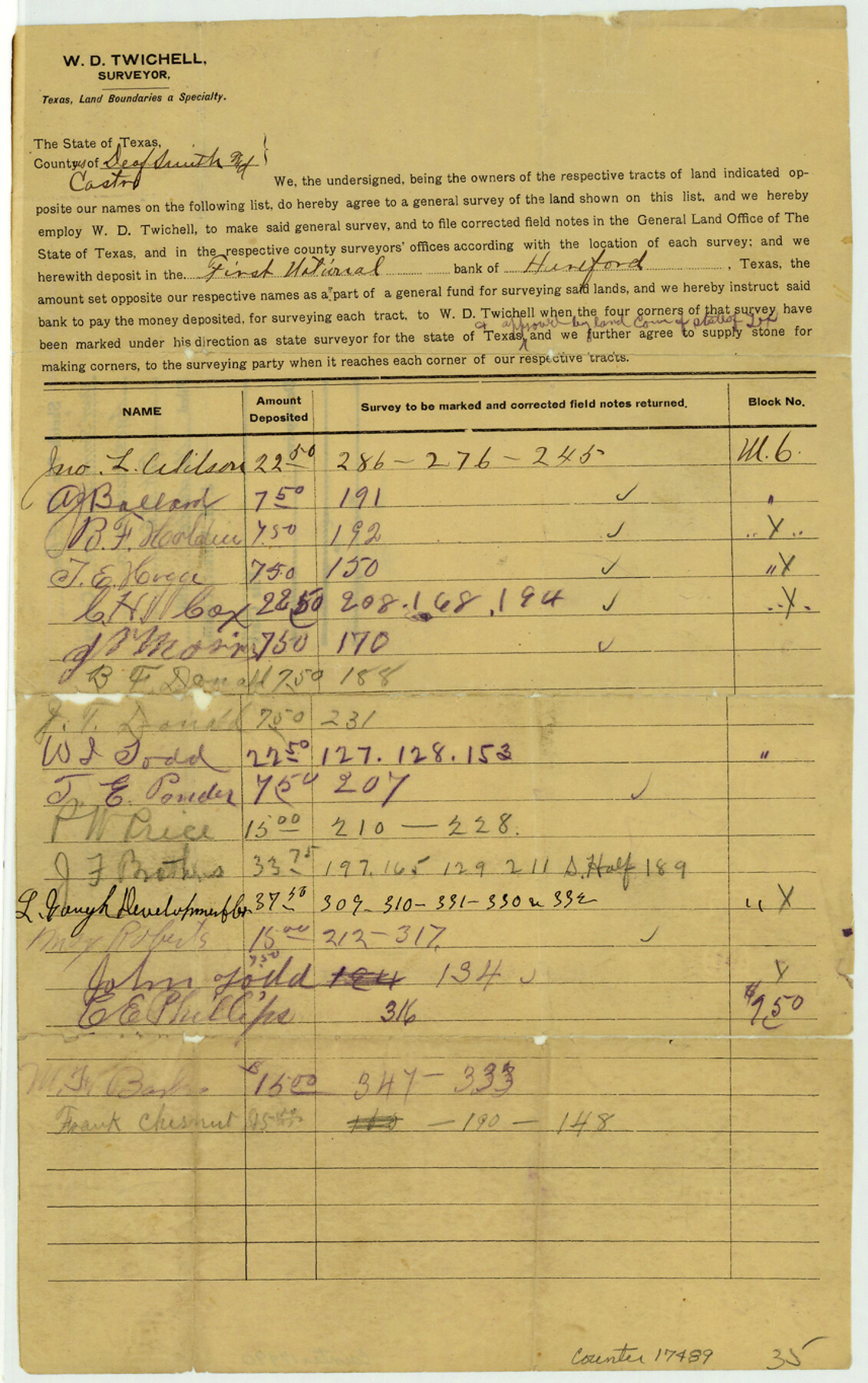
Castro County Sketch File 4m
[Agreement for W.D. Twichell to survey mulitple sections within Block M6 in Deaf Smith and Castro Counties]
-
Map/Doc
17489
-
Collection
General Map Collection
-
People and Organizations
W.D. Twichell (Surveyor/Engineer)
-
Counties
Castro Deaf Smith Randall
-
Subjects
Surveying Sketch File
-
Height x Width
13.6 x 8.6 inches
34.5 x 21.8 cm
-
Medium
paper, print with manuscript additions
Part of: General Map Collection
Burnet County Boundary File 6

Print $14.00
- Digital $50.00
Burnet County Boundary File 6
Size 14.1 x 8.6 inches
Map/Doc 50886
Milam County Sketch File 8

Print $20.00
- Digital $50.00
Milam County Sketch File 8
1856
Size 16.8 x 33.7 inches
Map/Doc 12091
[Sketch of expeditions, trails in Jones, Taylor, Shackelford, Callahan, Buchanan/Stephens and Eastland Counties]
![65406, [Sketch of expeditions, trails in Jones, Taylor, Shackelford, Callahan, Buchanan/Stephens and Eastland Counties], General Map Collection](https://historictexasmaps.com/wmedia_w700/maps/65406.tif.jpg)
Print $4.00
- Digital $50.00
[Sketch of expeditions, trails in Jones, Taylor, Shackelford, Callahan, Buchanan/Stephens and Eastland Counties]
1873
Size 10.7 x 18.1 inches
Map/Doc 65406
Uvalde County Sketch File 17

Print $20.00
- Digital $50.00
Uvalde County Sketch File 17
1882
Size 17.5 x 17.9 inches
Map/Doc 12531
Supreme Court of the United States, October Term, 1923, No. 15, Original - The State of Oklahoma, Complainant vs. The State of Texas, Defendant, The United States, Intervener; Report of the Boundary Commissioners

Print $40.00
- Digital $50.00
Supreme Court of the United States, October Term, 1923, No. 15, Original - The State of Oklahoma, Complainant vs. The State of Texas, Defendant, The United States, Intervener; Report of the Boundary Commissioners
1923
Size 57.5 x 33.4 inches
Map/Doc 77591
Flight Mission No. CGI-4N, Frame 23, Cameron County

Print $20.00
- Digital $50.00
Flight Mission No. CGI-4N, Frame 23, Cameron County
1954
Size 18.6 x 22.4 inches
Map/Doc 84656
Ector County Working Sketch 19

Print $40.00
- Digital $50.00
Ector County Working Sketch 19
1958
Size 65.8 x 37.6 inches
Map/Doc 68862
Andrews County Working Sketch 15

Print $40.00
- Digital $50.00
Andrews County Working Sketch 15
1957
Size 50.5 x 36.1 inches
Map/Doc 67061
Nueces County Sketch File 70

Print $8.00
- Digital $50.00
Nueces County Sketch File 70
Size 11.2 x 8.6 inches
Map/Doc 33007
Lynn County Boundary File 14

Print $6.00
- Digital $50.00
Lynn County Boundary File 14
Size 8.9 x 14.2 inches
Map/Doc 56754
Harris County Sketch File 78

Print $32.00
- Digital $50.00
Harris County Sketch File 78
1955
Size 8.7 x 9.0 inches
Map/Doc 25549
Chambers County Rolled Sketch 19

Print $20.00
- Digital $50.00
Chambers County Rolled Sketch 19
Size 39.8 x 44.4 inches
Map/Doc 8588
You may also like
Railroad Track Map, H&TCRRCo., Falls County, Texas

Print $4.00
- Digital $50.00
Railroad Track Map, H&TCRRCo., Falls County, Texas
1918
Size 11.6 x 18.6 inches
Map/Doc 62834
[Surveys in Mills, Hamilton, Coryell and Bell Counties]
![78362, [Surveys in Mills, Hamilton, Coryell and Bell Counties], General Map Collection](https://historictexasmaps.com/wmedia_w700/maps/78362.tif.jpg)
Print $20.00
- Digital $50.00
[Surveys in Mills, Hamilton, Coryell and Bell Counties]
Size 33.9 x 19.5 inches
Map/Doc 78362
[North line of T. C. RR. Blk on North County Line]
![90516, [North line of T. C. RR. Blk on North County Line], Twichell Survey Records](https://historictexasmaps.com/wmedia_w700/maps/90516-1.tif.jpg)
Print $2.00
- Digital $50.00
[North line of T. C. RR. Blk on North County Line]
Size 13.7 x 5.1 inches
Map/Doc 90516
General Highway Map. Detail of Cities and Towns in Cherokee County, Texas [Jacksonville, Rusk, Alto, Wells, and vicinities of these cities]
![79407, General Highway Map. Detail of Cities and Towns in Cherokee County, Texas [Jacksonville, Rusk, Alto, Wells, and vicinities of these cities], Texas State Library and Archives](https://historictexasmaps.com/wmedia_w700/maps/79407.tif.jpg)
Print $20.00
General Highway Map. Detail of Cities and Towns in Cherokee County, Texas [Jacksonville, Rusk, Alto, Wells, and vicinities of these cities]
1961
Size 18.2 x 24.9 inches
Map/Doc 79407
Aransas County Sketch File B

Print $4.00
- Digital $50.00
Aransas County Sketch File B
Size 6.9 x 11.4 inches
Map/Doc 13216
Chambers County Rolled Sketch 24A

Print $40.00
- Digital $50.00
Chambers County Rolled Sketch 24A
1940
Size 36.5 x 49.0 inches
Map/Doc 8595
Gregg County Rolled Sketch 25

Print $40.00
- Digital $50.00
Gregg County Rolled Sketch 25
1933
Size 27.3 x 51.7 inches
Map/Doc 9076
Coleman County Sketch File 44

Print $17.00
- Digital $50.00
Coleman County Sketch File 44
Size 14.1 x 8.6 inches
Map/Doc 18783
Clay County Sketch File 14

Print $40.00
- Digital $50.00
Clay County Sketch File 14
1873
Size 16.5 x 13.8 inches
Map/Doc 18417
[H. & G. N. RR. Co. Block 1]
![90889, [H. & G. N. RR. Co. Block 1], Twichell Survey Records](https://historictexasmaps.com/wmedia_w700/maps/90889-1.tif.jpg)
Print $20.00
- Digital $50.00
[H. & G. N. RR. Co. Block 1]
Size 16.5 x 27.9 inches
Map/Doc 90889
Presidio County Working Sketch 58

Print $20.00
- Digital $50.00
Presidio County Working Sketch 58
1956
Size 21.9 x 24.2 inches
Map/Doc 71735
