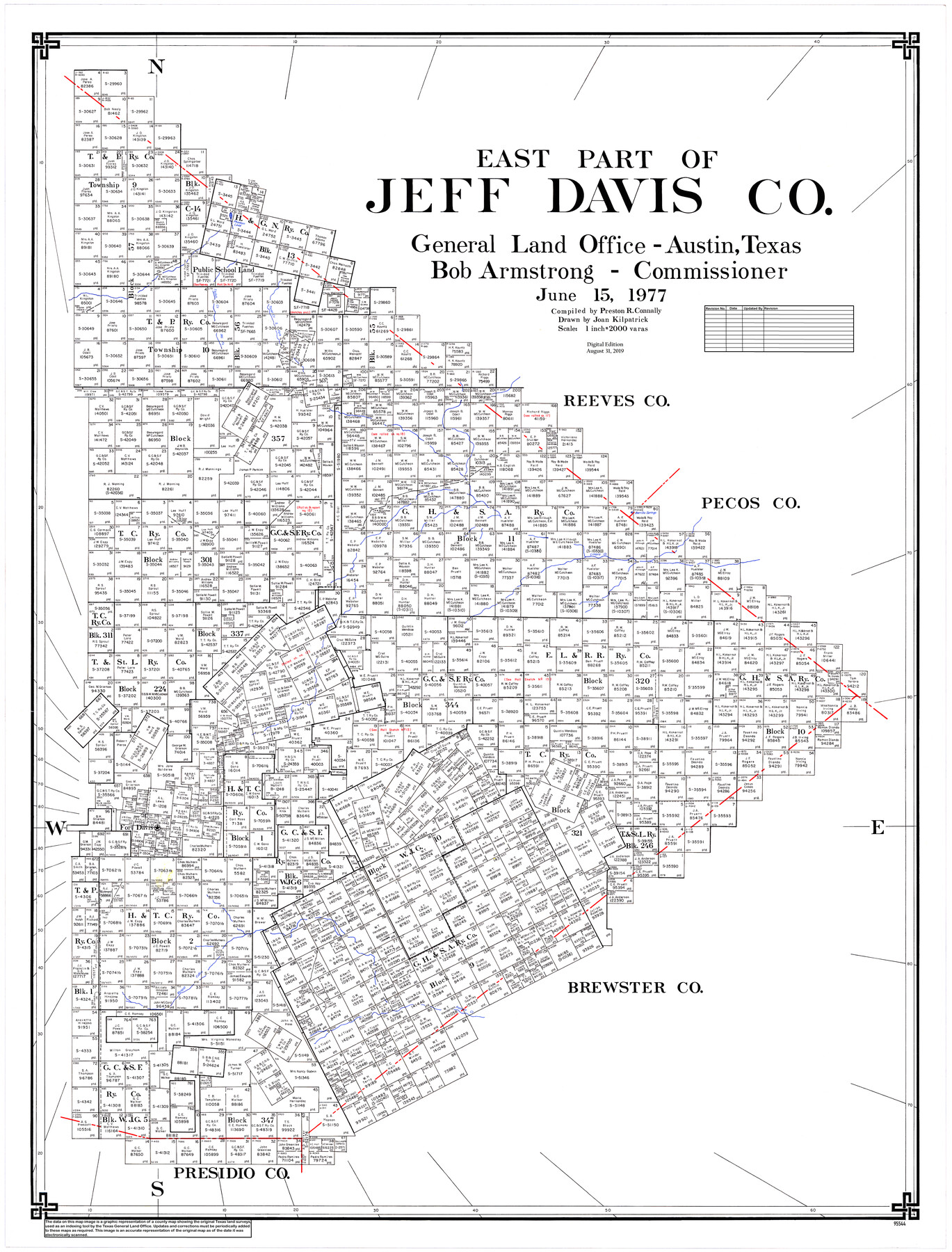
East Part of Jeff Davis Co.
General Land Office Official County Map
-
Map/Doc
95544
-
Collection
General Map Collection
-
Object Dates
2019/8/31 (Revision Date)
1977/6/15 (Creation Date)
-
People and Organizations
Cheyenne Betancourt (Draftsman)
Joan Kilpatrick (Draftsman)
Preston R. Connally (Compiler)
Bob Armstrong (GLO Commissioner)
-
Counties
Jeff Davis
-
Subjects
County OCM
-
Height x Width
47.9 x 36.9 inches
121.7 x 93.7 cm
-
Medium
digital image
-
Scale
1" = 2000 varas
-
Comments
For central part of Jeff Davis County see 95543 and for west part of Jeff Davis County see 95545.
Related maps
Central Part of Jeff Davis Co.

Print $40.00
- Digital $50.00
Central Part of Jeff Davis Co.
1982
Size 56.3 x 43.9 inches
Map/Doc 95543
West Part of Jeff Davis Co.

Print $20.00
- Digital $50.00
West Part of Jeff Davis Co.
1977
Size 36.5 x 47.5 inches
Map/Doc 95545
Part of: General Map Collection

Nueces County Rolled Sketch 66

Print $46.00
- Digital $50.00
Nueces County Rolled Sketch 66
1979
Size 26.1 x 37.4 inches
Map/Doc 9608
[Copy from Harris County map]
![78371, [Copy from Harris County map], General Map Collection](https://historictexasmaps.com/wmedia_w700/maps/78371.tif.jpg)
Print $2.00
- Digital $50.00
[Copy from Harris County map]
Size 7.4 x 3.9 inches
Map/Doc 78371
Atascosa County Rolled Sketch 5

Print $20.00
- Digital $50.00
Atascosa County Rolled Sketch 5
1910
Size 22.1 x 15.8 inches
Map/Doc 5088
Tarrant County Sketch File 15

Print $4.00
- Digital $50.00
Tarrant County Sketch File 15
1859
Size 13.2 x 8.1 inches
Map/Doc 37708
Gillespie County Boundary File 7a

Print $40.00
- Digital $50.00
Gillespie County Boundary File 7a
Size 8.7 x 51.2 inches
Map/Doc 53780
Maverick County Working Sketch 16

Print $20.00
- Digital $50.00
Maverick County Working Sketch 16
1975
Size 38.1 x 27.6 inches
Map/Doc 70908
Cameron County Rolled Sketch 34

Print $20.00
- Digital $50.00
Cameron County Rolled Sketch 34
2000
Size 24.2 x 35.2 inches
Map/Doc 5397
Matagorda County Working Sketch 6

Print $20.00
- Digital $50.00
Matagorda County Working Sketch 6
1950
Size 24.2 x 41.5 inches
Map/Doc 70864
Nolan County Sketch File 3

Print $20.00
- Digital $50.00
Nolan County Sketch File 3
Size 8.0 x 36.6 inches
Map/Doc 42161
San Patricio County Sketch File 21

Print $6.00
San Patricio County Sketch File 21
1913
Size 10.3 x 13.7 inches
Map/Doc 36076
Foard County Sketch File 30

Print $6.00
- Digital $50.00
Foard County Sketch File 30
Size 9.1 x 8.2 inches
Map/Doc 22858
You may also like
Red River County Working Sketch 32

Print $20.00
- Digital $50.00
Red River County Working Sketch 32
1962
Size 27.6 x 20.0 inches
Map/Doc 72015
Flight Mission No. CRC-3R, Frame 203, Chambers County

Print $20.00
- Digital $50.00
Flight Mission No. CRC-3R, Frame 203, Chambers County
1956
Size 18.6 x 22.3 inches
Map/Doc 84858
Flight Mission No. DAG-28K, Frame 22, Matagorda County

Print $20.00
- Digital $50.00
Flight Mission No. DAG-28K, Frame 22, Matagorda County
1953
Size 18.4 x 22.3 inches
Map/Doc 86590
Palo Pinto County Working Sketch 25

Print $20.00
- Digital $50.00
Palo Pinto County Working Sketch 25
1991
Map/Doc 71408
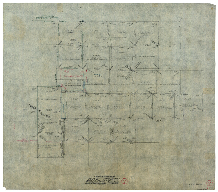
Duval County Working Sketch 9
Print $20.00
- Digital $50.00
Duval County Working Sketch 9
1935
Size 25.8 x 29.1 inches
Map/Doc 68722
Plat showing survey of tracts in the C. A. West survey A-337 and the Wm. Standiferd survey A-301 in Bastrop County as surveyed for the Veteran's Land Board

Print $20.00
- Digital $50.00
Plat showing survey of tracts in the C. A. West survey A-337 and the Wm. Standiferd survey A-301 in Bastrop County as surveyed for the Veteran's Land Board
1992
Size 34.9 x 46.8 inches
Map/Doc 61151
El Paso County Working Sketch 57

Print $20.00
- Digital $50.00
El Paso County Working Sketch 57
Size 37.5 x 37.4 inches
Map/Doc 69079
Culberson County Working Sketch 44

Print $40.00
- Digital $50.00
Culberson County Working Sketch 44
1970
Size 53.4 x 36.4 inches
Map/Doc 68498
Van Zandt County Sketch File 47a

Print $7.00
- Digital $50.00
Van Zandt County Sketch File 47a
1875
Size 10.0 x 8.2 inches
Map/Doc 39507
General Highway Map, Angelina County, Texas

Print $20.00
General Highway Map, Angelina County, Texas
1961
Size 25.1 x 18.4 inches
Map/Doc 79350
Scurry County Rolled Sketch 12

Print $20.00
- Digital $50.00
Scurry County Rolled Sketch 12
1983
Size 27.7 x 27.0 inches
Map/Doc 7772
University Lands Blocks 21 to 26, Pecos County, Texas

Print $40.00
- Digital $50.00
University Lands Blocks 21 to 26, Pecos County, Texas
1939
Size 48.4 x 39.9 inches
Map/Doc 2450