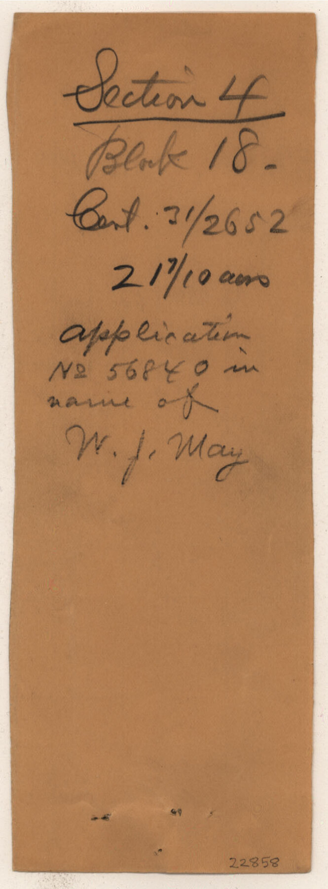
Foard County Sketch File 30
[List of subdivisions in sections 4, 6, 12, 40 and 44, Block 18]
-
Map/Doc
22858
-
Collection
General Map Collection
-
People and Organizations
von Rosenberg (Surveyor/Engineer)
-
Counties
Foard
-
Subjects
Surveying Sketch File
-
Height x Width
9.1 x 8.2 inches
23.1 x 20.8 cm
-
Medium
paper, manuscript
Part of: General Map Collection
Flight Mission No. CGI-3N, Frame 67, Cameron County

Print $20.00
- Digital $50.00
Flight Mission No. CGI-3N, Frame 67, Cameron County
1954
Size 18.5 x 22.2 inches
Map/Doc 84561
Stonewall County Sketch File 12 and 12a

Print $30.00
- Digital $50.00
Stonewall County Sketch File 12 and 12a
1900
Size 9.2 x 9.0 inches
Map/Doc 37240
Tyler County Working Sketch 22

Print $20.00
- Digital $50.00
Tyler County Working Sketch 22
1987
Size 42.0 x 35.5 inches
Map/Doc 69492
Index sheet to accompany map of survey for connecting the inland waters along margin of the Gulf of Mexico from Donaldsonville in Louisiana to the Rio Grande River in Texas

Print $20.00
- Digital $50.00
Index sheet to accompany map of survey for connecting the inland waters along margin of the Gulf of Mexico from Donaldsonville in Louisiana to the Rio Grande River in Texas
1873
Size 18.2 x 28.2 inches
Map/Doc 72693
Orange County Working Sketch 52

Print $20.00
- Digital $50.00
Orange County Working Sketch 52
2006
Size 31.9 x 47.5 inches
Map/Doc 83069
Clay County Sketch File 6

Print $4.00
- Digital $50.00
Clay County Sketch File 6
1854
Size 8.1 x 12.5 inches
Map/Doc 18395
Nacogdoches County Sketch File 3

Print $8.00
- Digital $50.00
Nacogdoches County Sketch File 3
Size 6.5 x 8.2 inches
Map/Doc 32237
Ashburn's San Antonio City Map

Ashburn's San Antonio City Map
1951
Size 24.5 x 19.5 inches
Map/Doc 97144
Schleicher County Rolled Sketch 16

Print $20.00
- Digital $50.00
Schleicher County Rolled Sketch 16
Size 27.4 x 29.0 inches
Map/Doc 7758
Map of Darrington State Farm, Brazoria County, Texas

Print $20.00
- Digital $50.00
Map of Darrington State Farm, Brazoria County, Texas
Size 18.5 x 37.9 inches
Map/Doc 62985
Flight Mission No. BRA-6M, Frame 151, Jefferson County

Print $20.00
- Digital $50.00
Flight Mission No. BRA-6M, Frame 151, Jefferson County
1953
Size 18.6 x 22.1 inches
Map/Doc 85452
Motley County Working Sketch 6

Print $20.00
- Digital $50.00
Motley County Working Sketch 6
1963
Size 17.6 x 29.3 inches
Map/Doc 71211
You may also like
[Sketch for Mineral Application 16700 - Pecos River Bed]
![2809, [Sketch for Mineral Application 16700 - Pecos River Bed], General Map Collection](https://historictexasmaps.com/wmedia_w700/maps/2809.tif.jpg)
Print $20.00
- Digital $50.00
[Sketch for Mineral Application 16700 - Pecos River Bed]
1927
Size 14.8 x 30.8 inches
Map/Doc 2809
Val Verde County Rolled Sketch 51

Print $40.00
- Digital $50.00
Val Verde County Rolled Sketch 51
1937
Size 29.4 x 48.4 inches
Map/Doc 10075
South Part Brewster Co.

Print $40.00
- Digital $50.00
South Part Brewster Co.
1910
Size 32.0 x 49.7 inches
Map/Doc 66728
Tom Green County Sketch File 46

Print $82.00
- Digital $50.00
Tom Green County Sketch File 46
1883
Size 28.4 x 28.6 inches
Map/Doc 10402
North Part Brewster Co.

Print $40.00
- Digital $50.00
North Part Brewster Co.
1914
Size 40.6 x 49.2 inches
Map/Doc 66729
Montague County Working Sketch 35

Print $20.00
- Digital $50.00
Montague County Working Sketch 35
1980
Size 24.8 x 31.9 inches
Map/Doc 71101
Kleberg County Rolled Sketch 10-11

Print $20.00
- Digital $50.00
Kleberg County Rolled Sketch 10-11
1951
Size 38.2 x 33.8 inches
Map/Doc 9374
Kleberg County Aerial Photograph Index Sheet 7

Print $20.00
- Digital $50.00
Kleberg County Aerial Photograph Index Sheet 7
1956
Size 24.0 x 20.1 inches
Map/Doc 83724
Uvalde County Rolled Sketch 15

Print $20.00
- Digital $50.00
Uvalde County Rolled Sketch 15
1979
Size 26.9 x 23.9 inches
Map/Doc 8099
Flight Mission No. BRA-16M, Frame 174, Jefferson County

Print $20.00
- Digital $50.00
Flight Mission No. BRA-16M, Frame 174, Jefferson County
1953
Size 18.6 x 22.4 inches
Map/Doc 85772
Map in the Southern Portion of Pecos County Texas

Print $40.00
- Digital $50.00
Map in the Southern Portion of Pecos County Texas
1882
Size 64.6 x 21.6 inches
Map/Doc 89692
[Blocks M18, M23, I, Z, and Block 47, Sections 16-28]
![91244, [Blocks M18, M23, I, Z, and Block 47, Sections 16-28], Twichell Survey Records](https://historictexasmaps.com/wmedia_w700/maps/91244-1.tif.jpg)
Print $20.00
- Digital $50.00
[Blocks M18, M23, I, Z, and Block 47, Sections 16-28]
Size 19.5 x 23.6 inches
Map/Doc 91244