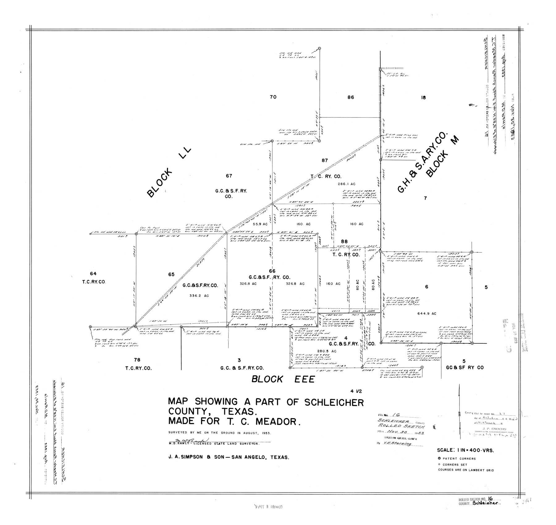
Schleicher County Rolled Sketch 16
Map showing a part of Schleicher County, Texas made for T.C. Meador
-
Map/Doc
7758
-
Collection
General Map Collection
-
Object Dates
1953 (Survey Date)
1953/11/30 (File Date)
-
People and Organizations
M.D. Rawls (Surveyor/Engineer)
-
Counties
Schleicher
-
Subjects
Surveying Rolled Sketch
-
Height x Width
27.4 x 29.0 inches
69.6 x 73.7 cm
-
Medium
mylar, print
-
Scale
1" = 400 varas
Part of: General Map Collection
Gillespie County Boundary File 3a

Print $20.00
- Digital $50.00
Gillespie County Boundary File 3a
Size 24.6 x 37.6 inches
Map/Doc 53753
Flight Mission No. DQN-5K, Frame 148, Calhoun County

Print $20.00
- Digital $50.00
Flight Mission No. DQN-5K, Frame 148, Calhoun County
1953
Size 18.6 x 21.9 inches
Map/Doc 84423
Milam County Working Sketch Graphic Index

Print $40.00
- Digital $50.00
Milam County Working Sketch Graphic Index
1975
Size 51.6 x 42.7 inches
Map/Doc 76642
Donley County Sketch File 4

Print $28.00
- Digital $50.00
Donley County Sketch File 4
1881
Size 12.8 x 8.3 inches
Map/Doc 21219
Supreme Court of the United States, October Term, 1924, No. 13, Original - The State of Oklahoma, Complainant vs. The State of Texas, Defendant, The United States, Intervener

Print $20.00
- Digital $50.00
Supreme Court of the United States, October Term, 1924, No. 13, Original - The State of Oklahoma, Complainant vs. The State of Texas, Defendant, The United States, Intervener
1924
Size 32.0 x 32.8 inches
Map/Doc 75132
Kent County Working Sketch 6

Print $20.00
- Digital $50.00
Kent County Working Sketch 6
1952
Size 27.4 x 23.8 inches
Map/Doc 70013
Menard County Rolled Sketch 4

Print $20.00
- Digital $50.00
Menard County Rolled Sketch 4
Size 18.5 x 14.3 inches
Map/Doc 6754
Motley County Sketch File 30 (S)

Print $40.00
- Digital $50.00
Motley County Sketch File 30 (S)
1905
Size 16.1 x 17.1 inches
Map/Doc 42147
Flight Mission No. CGI-1N, Frame 217, Cameron County

Print $20.00
- Digital $50.00
Flight Mission No. CGI-1N, Frame 217, Cameron County
1955
Size 18.6 x 22.2 inches
Map/Doc 84526
Cottle County Sketch File A and C

Print $68.00
- Digital $50.00
Cottle County Sketch File A and C
1902
Size 12.7 x 8.0 inches
Map/Doc 19422
Hidalgo County Sketch File 19

Print $42.00
- Digital $50.00
Hidalgo County Sketch File 19
1983
Size 11.3 x 8.9 inches
Map/Doc 26448
Presidio County Working Sketch 73

Print $20.00
- Digital $50.00
Presidio County Working Sketch 73
1962
Size 17.7 x 29.4 inches
Map/Doc 71750
You may also like

Terrell County Working Sketch 26

Print $20.00
- Digital $50.00
Terrell County Working Sketch 26
1943
Size 17.5 x 14.0 inches
Map/Doc 62176
[F. W. & D. C. Ry. Co. Alignment and Right of Way Map, Clay County]
![64732, [F. W. & D. C. Ry. Co. Alignment and Right of Way Map, Clay County], General Map Collection](https://historictexasmaps.com/wmedia_w700/maps/64732-GC.tif.jpg)
Print $20.00
- Digital $50.00
[F. W. & D. C. Ry. Co. Alignment and Right of Way Map, Clay County]
1927
Size 18.6 x 11.8 inches
Map/Doc 64732
Trinity County Boundary File 88a

Print $4.00
- Digital $50.00
Trinity County Boundary File 88a
Size 12.6 x 7.8 inches
Map/Doc 59478
Bosque County Working Sketch 4

Print $20.00
- Digital $50.00
Bosque County Working Sketch 4
1901
Size 14.2 x 18.6 inches
Map/Doc 67437
Sketch in Cochran County, Texas

Print $20.00
- Digital $50.00
Sketch in Cochran County, Texas
1949
Size 22.4 x 21.6 inches
Map/Doc 92523
Runnels County

Print $40.00
- Digital $50.00
Runnels County
1948
Size 49.4 x 38.7 inches
Map/Doc 63010
Upton County Rolled Sketch 14

Print $20.00
- Digital $50.00
Upton County Rolled Sketch 14
Size 43.2 x 32.0 inches
Map/Doc 10038
Hunt County Working Sketch 11

Print $20.00
- Digital $50.00
Hunt County Working Sketch 11
2002
Size 32.1 x 29.6 inches
Map/Doc 66358
Flight Mission No. BRE-2P, Frame 108, Nueces County

Print $20.00
- Digital $50.00
Flight Mission No. BRE-2P, Frame 108, Nueces County
1956
Size 18.5 x 22.5 inches
Map/Doc 86793
Flight Mission No. BRA-7M, Frame 77, Jefferson County

Print $20.00
- Digital $50.00
Flight Mission No. BRA-7M, Frame 77, Jefferson County
1953
Size 16.0 x 16.0 inches
Map/Doc 85499
Morris County Sketch File 4

Print $4.00
- Digital $50.00
Morris County Sketch File 4
1910
Size 8.3 x 8.6 inches
Map/Doc 31968