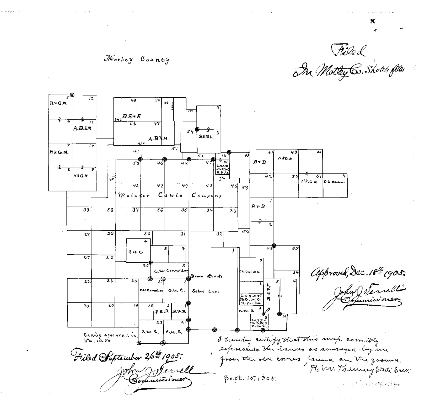
Motley County Sketch File 30 (S)
Sketch of Matador Cattle Co. Surveys, Motley County, Texas
-
Map/Doc
42147
-
Collection
General Map Collection
-
Object Dates
9/15/1905 (Creation Date)
12/18/1905 (File Date)
9/26/1905 (File Date)
4/18/1903 (File Date)
-
People and Organizations
R.M. Kenney (Surveyor/Engineer)
-
Counties
Motley Dickens Floyd Crosby
-
Subjects
Surveying Sketch File
-
Height x Width
16.1 x 17.1 inches
40.9 x 43.4 cm
-
Medium
multi-page, multi-format
-
Scale
1" = 2000 varas
-
Features
South Pease River
Grape Vine Creek
Mexican Creek
Rustler Creek
Part of: General Map Collection

Gaines County Rolled Sketch 7

Print $40.00
- Digital $50.00
Gaines County Rolled Sketch 7
1915
Size 35.7 x 54.0 inches
Map/Doc 9014
Orange County Working Sketch 17

Print $20.00
- Digital $50.00
Orange County Working Sketch 17
1930
Size 35.6 x 26.1 inches
Map/Doc 71349
Hale County Sketch File 26

Print $40.00
- Digital $50.00
Hale County Sketch File 26
1911
Size 20.7 x 54.4 inches
Map/Doc 10471
Rockwall County Boundary File 7

Print $4.00
- Digital $50.00
Rockwall County Boundary File 7
Size 11.5 x 8.8 inches
Map/Doc 58426
Walker County Sketch File 6

Print $4.00
- Digital $50.00
Walker County Sketch File 6
1876
Size 8.1 x 6.1 inches
Map/Doc 39557
La Salle County Working Sketch 13

Print $20.00
- Digital $50.00
La Salle County Working Sketch 13
1930
Size 36.2 x 40.3 inches
Map/Doc 70314
Flight Mission No. DQN-5K, Frame 23, Calhoun County

Print $20.00
- Digital $50.00
Flight Mission No. DQN-5K, Frame 23, Calhoun County
1953
Size 18.5 x 22.1 inches
Map/Doc 84374
Kaufman County State Real Property Sketch 1

Print $92.00
- Digital $50.00
Kaufman County State Real Property Sketch 1
2006
Size 24.6 x 35.4 inches
Map/Doc 88624
Galveston to Rio Grande

Print $20.00
- Digital $50.00
Galveston to Rio Grande
1961
Size 44.4 x 37.2 inches
Map/Doc 69954
Hutchinson County Rolled Sketch 40

Print $20.00
- Digital $50.00
Hutchinson County Rolled Sketch 40
1981
Size 25.7 x 37.3 inches
Map/Doc 6304
Hamilton County Working Sketch 33

Print $20.00
- Digital $50.00
Hamilton County Working Sketch 33
Size 32.3 x 33.3 inches
Map/Doc 63371
You may also like
[Leagues 464-467]
![91555, [Leagues 464-467], Twichell Survey Records](https://historictexasmaps.com/wmedia_w700/maps/91555-1.tif.jpg)
Print $20.00
- Digital $50.00
[Leagues 464-467]
Size 19.4 x 15.1 inches
Map/Doc 91555
Glasscock County Sketch File 2

Print $20.00
- Digital $50.00
Glasscock County Sketch File 2
1931
Size 35.1 x 16.2 inches
Map/Doc 11559
Map of the United States and their Territories between the Mississippi and the Pacific Ocean and part of Mexico

Print $20.00
- Digital $50.00
Map of the United States and their Territories between the Mississippi and the Pacific Ocean and part of Mexico
1858
Size 23.5 x 26.5 inches
Map/Doc 96526
Crockett County Rolled Sketch RC1

Print $20.00
- Digital $50.00
Crockett County Rolled Sketch RC1
1935
Size 43.7 x 30.6 inches
Map/Doc 8701
Flight Mission No. DIX-10P, Frame 150, Aransas County

Print $20.00
- Digital $50.00
Flight Mission No. DIX-10P, Frame 150, Aransas County
1956
Size 18.7 x 22.3 inches
Map/Doc 83952

Swisher County

Print $20.00
- Digital $50.00
Swisher County
1879
Size 20.9 x 18.7 inches
Map/Doc 4063
Upton County Working Sketch 25

Print $20.00
- Digital $50.00
Upton County Working Sketch 25
1953
Size 38.2 x 31.2 inches
Map/Doc 69521
Kent County Working Sketch 25

Print $20.00
- Digital $50.00
Kent County Working Sketch 25
1989
Size 18.8 x 18.5 inches
Map/Doc 69641
[B. S. & F. Block M7]
![90393, [B. S. & F. Block M7], Twichell Survey Records](https://historictexasmaps.com/wmedia_w700/maps/90393-1.tif.jpg)
Print $20.00
- Digital $50.00
[B. S. & F. Block M7]
1905
Size 21.7 x 17.9 inches
Map/Doc 90393
Frio County Sketch File 5

Print $4.00
- Digital $50.00
Frio County Sketch File 5
1878
Size 7.9 x 11.2 inches
Map/Doc 23116
Travis County Appraisal District Plat Map 2_3013

Print $20.00
- Digital $50.00
Travis County Appraisal District Plat Map 2_3013
Size 21.5 x 26.4 inches
Map/Doc 94220