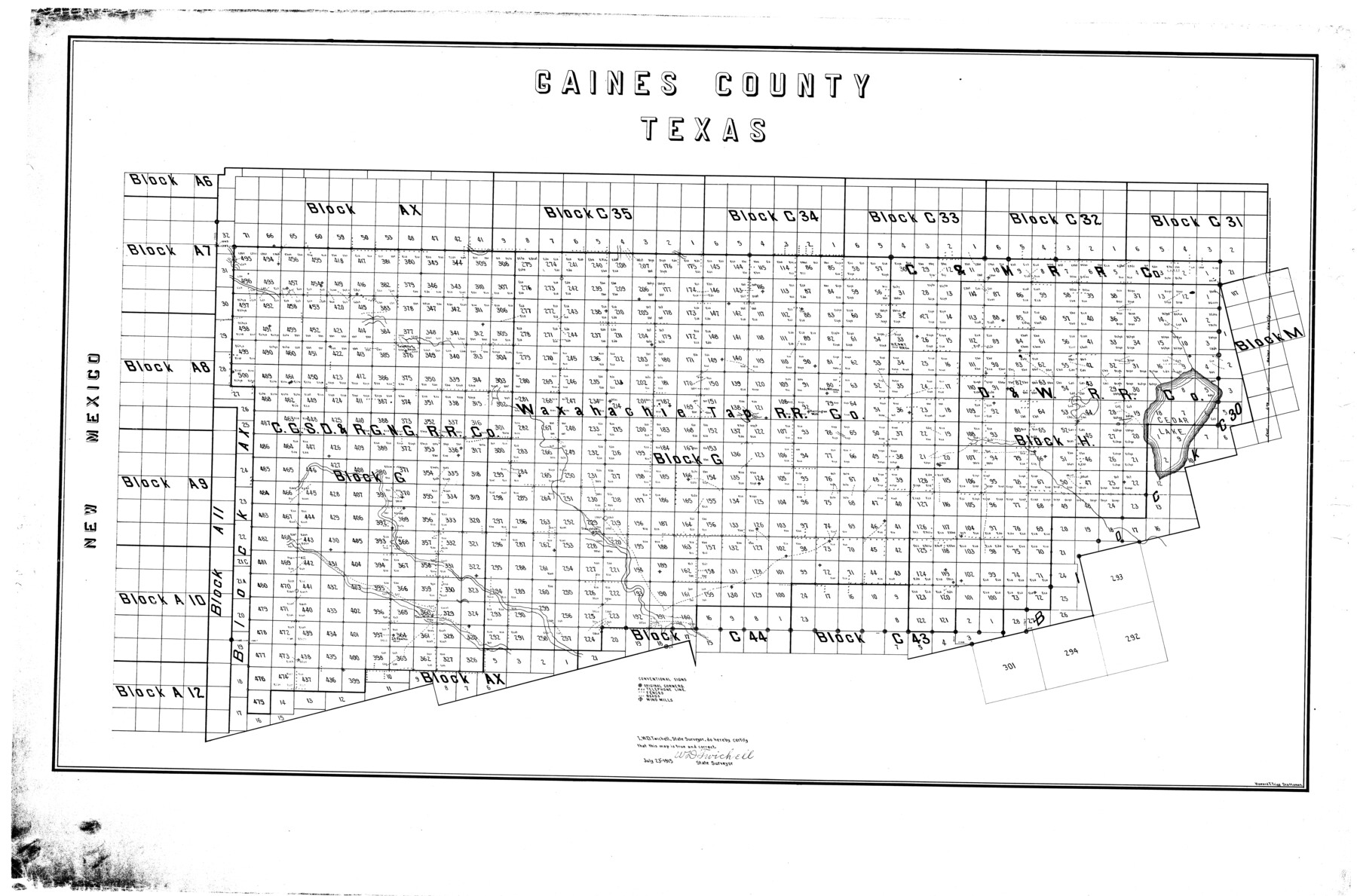
Gaines County Rolled Sketch 7
Gaines County, Texas
-
Map/Doc
9014
-
Collection
General Map Collection
-
Object Dates
7/23/1915 (Creation Date)
8/12/1915 (File Date)
-
People and Organizations
W.D. Twichell (Surveyor/Engineer)
-
Counties
Gaines
-
Subjects
Surveying Rolled Sketch
-
Height x Width
35.7 x 54.0 inches
90.7 x 137.2 cm
Part of: General Map Collection
Cameron County Sketch File 15

Print $26.00
- Digital $50.00
Cameron County Sketch File 15
1999
Size 11.2 x 8.7 inches
Map/Doc 17320
Burleson County Working Sketch 35

Print $3.00
- Digital $50.00
Burleson County Working Sketch 35
1981
Size 16.4 x 8.7 inches
Map/Doc 67754
Loving County Working Sketch 6

Print $40.00
- Digital $50.00
Loving County Working Sketch 6
1947
Size 31.3 x 51.0 inches
Map/Doc 70638
Nueces County Working Sketch Graphic Index

Print $20.00
- Digital $50.00
Nueces County Working Sketch Graphic Index
1913
Size 24.0 x 32.3 inches
Map/Doc 76655
Map of Winkler County

Print $20.00
- Digital $50.00
Map of Winkler County
1901
Size 43.1 x 36.6 inches
Map/Doc 4158
La Salle County Rolled Sketch 7

Print $40.00
- Digital $50.00
La Salle County Rolled Sketch 7
Size 38.7 x 48.0 inches
Map/Doc 10652
Brewster County

Print $20.00
- Digital $50.00
Brewster County
1920
Size 24.4 x 19.5 inches
Map/Doc 3330
Flight Mission No. DQN-5K, Frame 40, Calhoun County

Print $20.00
- Digital $50.00
Flight Mission No. DQN-5K, Frame 40, Calhoun County
1953
Size 18.6 x 22.1 inches
Map/Doc 84388
Webb County Sketch File F

Print $6.00
- Digital $50.00
Webb County Sketch File F
1900
Size 10.7 x 15.1 inches
Map/Doc 39699
Kimble County Sketch File 8

Print $14.00
- Digital $50.00
Kimble County Sketch File 8
1847
Size 7.7 x 7.0 inches
Map/Doc 28920
Flight Mission No. CRC-4R, Frame 152, Chambers County

Print $20.00
- Digital $50.00
Flight Mission No. CRC-4R, Frame 152, Chambers County
1956
Size 18.8 x 22.4 inches
Map/Doc 84915
Webb County Working Sketch 89

Print $20.00
- Digital $50.00
Webb County Working Sketch 89
1982
Size 44.6 x 43.0 inches
Map/Doc 72456
You may also like
Cameron County Sketch File 2

Print $98.00
- Digital $50.00
Cameron County Sketch File 2
1904
Size 14.3 x 8.7 inches
Map/Doc 16975
Jim Hogg County Sketch File 4

Print $8.00
- Digital $50.00
Jim Hogg County Sketch File 4
1926
Size 11.2 x 8.7 inches
Map/Doc 28404
Hamilton County Sketch File 8

Print $4.00
- Digital $50.00
Hamilton County Sketch File 8
1860
Size 12.2 x 8.0 inches
Map/Doc 24914
Menard County Sketch File 27

Print $8.00
- Digital $50.00
Menard County Sketch File 27
1943
Size 11.2 x 8.8 inches
Map/Doc 31564
Bailey County

Print $40.00
- Digital $50.00
Bailey County
1956
Size 49.4 x 31.4 inches
Map/Doc 95423
General Highway Map, Sterling County, Texas

Print $20.00
General Highway Map, Sterling County, Texas
1940
Size 24.9 x 18.4 inches
Map/Doc 79248
Reagan County Working Sketch 32
Print $20.00
- Digital $50.00
Reagan County Working Sketch 32
1965
Size 43.9 x 37.1 inches
Map/Doc 71874
McMullen County Rolled Sketch 3

Print $20.00
- Digital $50.00
McMullen County Rolled Sketch 3
1937
Size 16.2 x 37.2 inches
Map/Doc 6722
Pecos County Rolled Sketch 122

Print $20.00
- Digital $50.00
Pecos County Rolled Sketch 122
1945
Size 32.5 x 39.1 inches
Map/Doc 7263
Marion County Rolled Sketch 2

Print $40.00
- Digital $50.00
Marion County Rolled Sketch 2
1954
Size 82.7 x 43.2 inches
Map/Doc 76446
Geographically Correct Map of United States showing the Union Pacific System - Union Pacific R.R. Co., Oregon Short Line R.R. Co., Oregon-Washington R.R. & Nav. Co., Los Angeles & Salt Lake R.R. Co., St. Joseph & Grand Island Ry. Co. and connections

Print $20.00
- Digital $50.00
Geographically Correct Map of United States showing the Union Pacific System - Union Pacific R.R. Co., Oregon Short Line R.R. Co., Oregon-Washington R.R. & Nav. Co., Los Angeles & Salt Lake R.R. Co., St. Joseph & Grand Island Ry. Co. and connections
1922
Size 18.2 x 32.2 inches
Map/Doc 95771
United States - Gulf Coast - Padre I. and Laguna Madre Lat. 27° 12' to Lat. 26° 33' Texas

Print $20.00
- Digital $50.00
United States - Gulf Coast - Padre I. and Laguna Madre Lat. 27° 12' to Lat. 26° 33' Texas
1913
Size 26.9 x 18.2 inches
Map/Doc 72820