Cameron County Sketch File 15
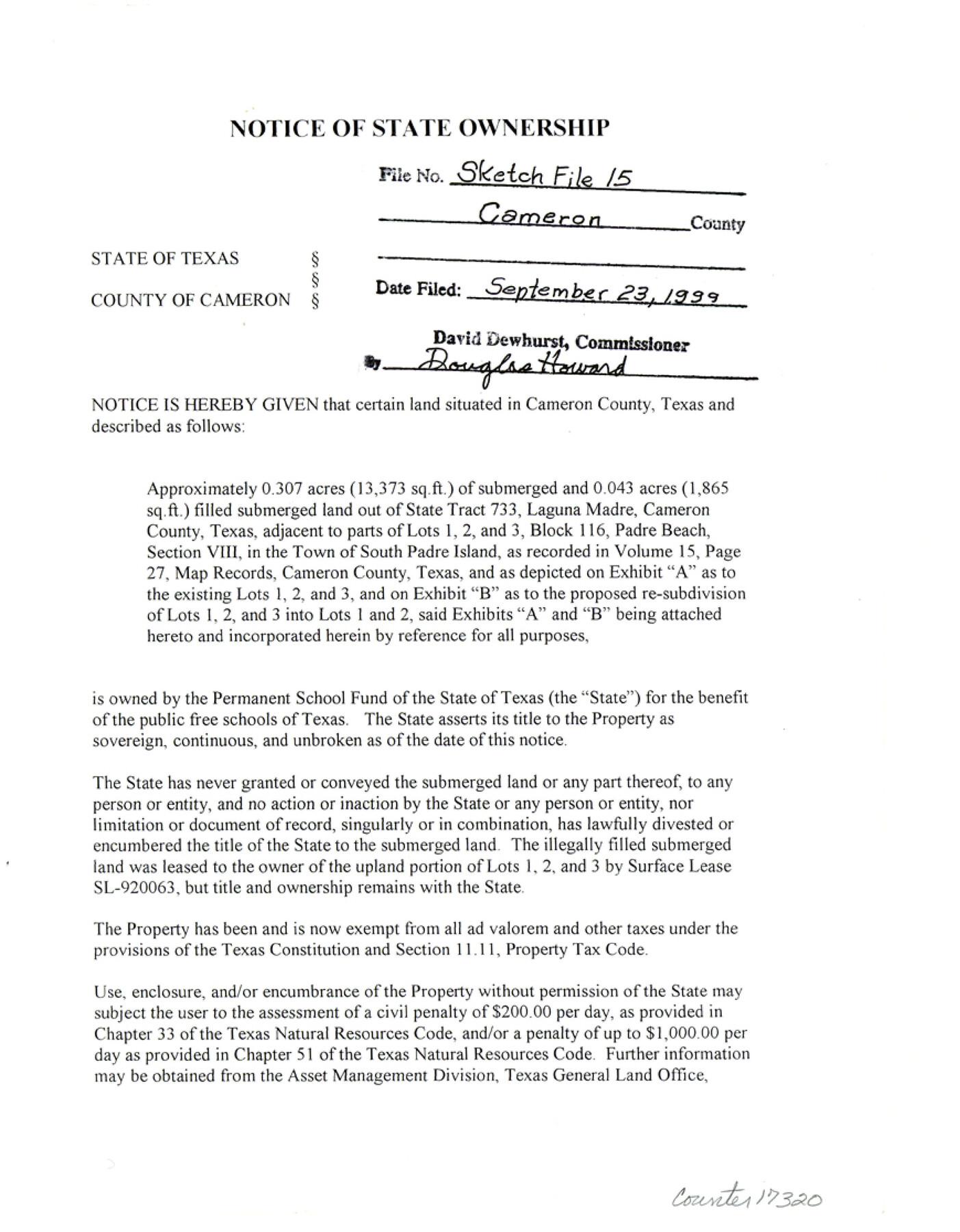
[Notice of State ownership of approximately 0.307 acres of submerged and 0.043 acres filled submerged land out of State Tract 733, Laguna Madre, adjacent to parts of Lots 1, 2, and 3, Block 116, Padre Beach Section VIII in the town of South Padre Island]
-
Map/Doc
17320
-
Collection
General Map Collection
-
Object Dates
1999/9/7 (Creation Date)
1999/9/23 (File Date)
-
People and Organizations
David Dewhurst (GLO Commissioner)
-
Counties
Cameron
-
Subjects
Surveying Sketch File
-
Height x Width
11.2 x 8.7 inches
28.4 x 22.1 cm
-
Medium
paper, print
-
Features
Laguna Madre
South Padre Island
Part of: General Map Collection
Harris County Rolled Sketch 87

Print $40.00
- Digital $50.00
Harris County Rolled Sketch 87
Size 45.2 x 49.8 inches
Map/Doc 9141
Cottle County Working Sketch 15

Print $40.00
- Digital $50.00
Cottle County Working Sketch 15
1965
Size 31.8 x 58.3 inches
Map/Doc 68325
Flight Mission No. CRC-5R, Frame 22, Chambers County

Print $20.00
- Digital $50.00
Flight Mission No. CRC-5R, Frame 22, Chambers County
1956
Size 18.7 x 22.6 inches
Map/Doc 84944
Caldwell County Working Sketch 10

Print $40.00
- Digital $50.00
Caldwell County Working Sketch 10
1977
Size 46.2 x 50.5 inches
Map/Doc 67840
El Paso County Sketch File 13

Print $8.00
- Digital $50.00
El Paso County Sketch File 13
1905
Size 7.4 x 6.8 inches
Map/Doc 22005
Hardin County Working Sketch 13

Print $20.00
- Digital $50.00
Hardin County Working Sketch 13
1934
Size 25.5 x 17.6 inches
Map/Doc 63411
Colorado County Sketch File 16

Print $4.00
- Digital $50.00
Colorado County Sketch File 16
Size 8.2 x 10.3 inches
Map/Doc 18945
Hardin County Sketch File A

Print $20.00
- Digital $50.00
Hardin County Sketch File A
Size 19.3 x 33.4 inches
Map/Doc 11644
Van Zandt County Sketch File 23

Print $4.00
- Digital $50.00
Van Zandt County Sketch File 23
1858
Size 6.8 x 8.2 inches
Map/Doc 39437
Flight Mission No. DQO-8K, Frame 59, Galveston County

Print $20.00
- Digital $50.00
Flight Mission No. DQO-8K, Frame 59, Galveston County
1952
Size 18.6 x 22.4 inches
Map/Doc 85166
Howard County Rolled Sketch 8

Print $20.00
- Digital $50.00
Howard County Rolled Sketch 8
Size 16.8 x 40.2 inches
Map/Doc 6237
Reagan County Rolled Sketch 16

Print $20.00
- Digital $50.00
Reagan County Rolled Sketch 16
Size 25.6 x 47.5 inches
Map/Doc 9811
You may also like
Stonewall County Working Sketch 8

Print $20.00
- Digital $50.00
Stonewall County Working Sketch 8
1950
Size 23.5 x 23.2 inches
Map/Doc 62315
Coryell County Sketch File 19

Print $20.00
- Digital $50.00
Coryell County Sketch File 19
Size 14.8 x 12.4 inches
Map/Doc 19380
Map of lands in King County, Texas owned and leased by the Louisville Land and Cattle Company

Print $20.00
- Digital $50.00
Map of lands in King County, Texas owned and leased by the Louisville Land and Cattle Company
Size 29.1 x 25.1 inches
Map/Doc 717
Township 12 North Range 16 West, North Western District, Louisiana

Print $20.00
- Digital $50.00
Township 12 North Range 16 West, North Western District, Louisiana
1837
Size 19.7 x 24.8 inches
Map/Doc 65868
Archer County Sketch File 28-1

Print $40.00
- Digital $50.00
Archer County Sketch File 28-1
1928
Size 23.8 x 22.0 inches
Map/Doc 10834
Stonewall County Working Sketch 35

Print $20.00
- Digital $50.00
Stonewall County Working Sketch 35
1991
Size 41.1 x 33.0 inches
Map/Doc 62342
Nueces County Sketch File 63

Print $4.00
- Digital $50.00
Nueces County Sketch File 63
1978
Size 14.2 x 8.5 inches
Map/Doc 32973
Aransas County Rolled Sketch 19A

Print $20.00
- Digital $50.00
Aransas County Rolled Sketch 19A
1979
Size 32.0 x 24.8 inches
Map/Doc 76068
Passage par terre a la Californie decouvert par le R.P. Eusebe-Francois Kino Jesuite depuis 1698 jusqua 1701 ou l'on voit encore les nouvelles Missions des PP. de la Compagnie de Texas

Print $20.00
- Digital $50.00
Passage par terre a la Californie decouvert par le R.P. Eusebe-Francois Kino Jesuite depuis 1698 jusqua 1701 ou l'on voit encore les nouvelles Missions des PP. de la Compagnie de Texas
1819
Size 10.7 x 10.6 inches
Map/Doc 96567
Real County Rolled Sketch 18

Print $20.00
- Digital $50.00
Real County Rolled Sketch 18
Size 22.0 x 28.0 inches
Map/Doc 7464
Starr County Sketch File 5

Print $40.00
- Digital $50.00
Starr County Sketch File 5
Size 31.4 x 40.7 inches
Map/Doc 82571
Flight Mission No. DAG-14K, Frame 142, Matagorda County

Print $20.00
- Digital $50.00
Flight Mission No. DAG-14K, Frame 142, Matagorda County
1952
Size 16.5 x 16.4 inches
Map/Doc 86309