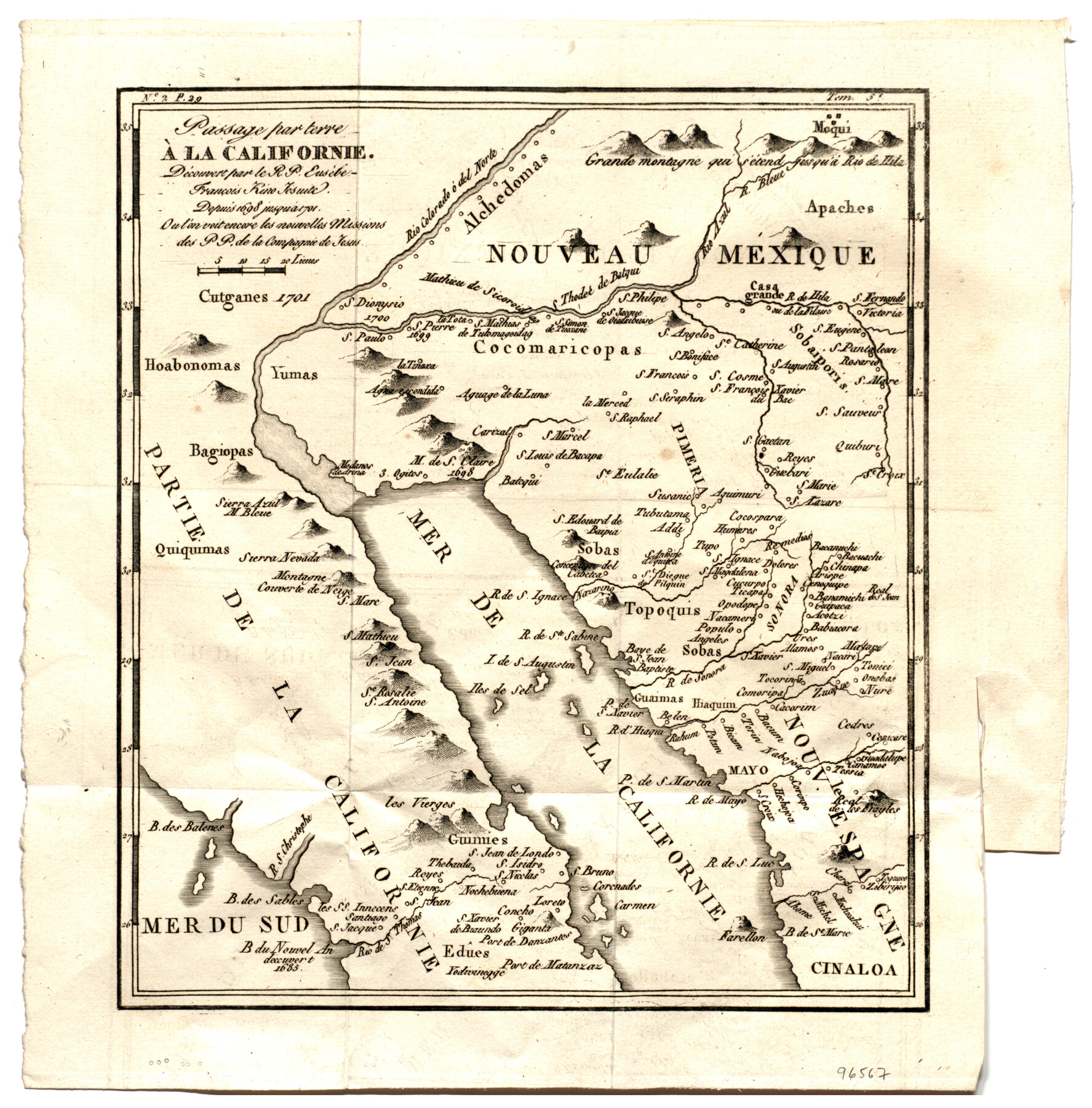
Passage par terre a la Californie decouvert par le R.P. Eusebe-Francois Kino Jesuite depuis 1698 jusqua 1701 ou l'on voit encore les nouvelles Missions des PP. de la Compagnie de Texas
-
Map/Doc
96567
-
Collection
General Map Collection
-
Object Dates
1819 (Creation Date)
1705 (Publication Date)
-
People and Organizations
Eusebe-Francois Kino (Cartographer)
-
Subjects
Spanish Texas
-
Height x Width
10.7 x 10.6 inches
27.2 x 26.9 cm
-
Medium
paper, etching/engraving/lithograph
-
Comments
Originally published in 1705.
Part of: General Map Collection
Edwards County Rolled Sketch O

Print $20.00
- Digital $50.00
Edwards County Rolled Sketch O
Size 13.6 x 18.3 inches
Map/Doc 5820
Duval County Rolled Sketch 40

Print $20.00
- Digital $50.00
Duval County Rolled Sketch 40
1958
Size 22.8 x 31.1 inches
Map/Doc 5757
Hutchinson County Rolled Sketch 44-4

Print $20.00
- Digital $50.00
Hutchinson County Rolled Sketch 44-4
2002
Size 24.0 x 36.0 inches
Map/Doc 77540
Briscoe County

Print $20.00
- Digital $50.00
Briscoe County
1879
Size 21.7 x 19.3 inches
Map/Doc 3332
Jefferson County Sketch File 55

Print $30.00
- Digital $50.00
Jefferson County Sketch File 55
1982
Size 11.1 x 8.5 inches
Map/Doc 28386
Van Zandt County Sketch File 8

Print $10.00
- Digital $50.00
Van Zandt County Sketch File 8
1851
Size 9.7 x 7.9 inches
Map/Doc 39379
Trinity River, Slate Rock Ferry Sheet/East Fork of Trinity River

Print $6.00
- Digital $50.00
Trinity River, Slate Rock Ferry Sheet/East Fork of Trinity River
1922
Size 35.1 x 34.3 inches
Map/Doc 65185
Liberty County Sketch File 11

Print $6.00
- Digital $50.00
Liberty County Sketch File 11
1858
Size 11.8 x 10.0 inches
Map/Doc 29905
Aransas Pass to Baffin Bay

Print $20.00
- Digital $50.00
Aransas Pass to Baffin Bay
1986
Size 44.7 x 35.7 inches
Map/Doc 73421
Hall County Working Sketch 7

Print $20.00
- Digital $50.00
Hall County Working Sketch 7
1955
Size 31.6 x 18.2 inches
Map/Doc 63335
Cottle County Working Sketch 17

Print $20.00
- Digital $50.00
Cottle County Working Sketch 17
1975
Size 32.5 x 34.1 inches
Map/Doc 68327
Hardeman County Rolled Sketch 25

Print $20.00
- Digital $50.00
Hardeman County Rolled Sketch 25
1985
Size 20.9 x 15.1 inches
Map/Doc 6075
You may also like
Map of Houston Co.

Print $40.00
- Digital $50.00
Map of Houston Co.
1896
Size 46.2 x 49.0 inches
Map/Doc 4688
Flight Mission No. DQO-11K, Frame 23, Galveston County

Print $20.00
- Digital $50.00
Flight Mission No. DQO-11K, Frame 23, Galveston County
1952
Size 18.8 x 22.4 inches
Map/Doc 85220
McLennan County Working Sketch Graphic Index

Print $20.00
- Digital $50.00
McLennan County Working Sketch Graphic Index
1946
Size 41.8 x 44.8 inches
Map/Doc 76637
Brewster County Working Sketch 86

Print $20.00
- Digital $50.00
Brewster County Working Sketch 86
1973
Size 27.6 x 27.7 inches
Map/Doc 67686
Swisher County Sketch File 7

Print $32.00
- Digital $50.00
Swisher County Sketch File 7
1904
Size 9.0 x 8.4 inches
Map/Doc 37622
Flight Mission No. CRK-3P, Frame 126, Refugio County

Print $20.00
- Digital $50.00
Flight Mission No. CRK-3P, Frame 126, Refugio County
1956
Size 18.6 x 22.4 inches
Map/Doc 86914
Holmes' Addition Located on North Part of SW Quarter Section 10, Block A

Print $20.00
- Digital $50.00
Holmes' Addition Located on North Part of SW Quarter Section 10, Block A
Size 20.7 x 8.5 inches
Map/Doc 92714
Sketch of the route from the camp on the Concho River to Phantom Hill, Texas

Print $20.00
- Digital $50.00
Sketch of the route from the camp on the Concho River to Phantom Hill, Texas
1852
Size 30.0 x 11.9 inches
Map/Doc 2005
The Texas and Pacific Ry. Co., Station Map, Loraine, Texas

Print $20.00
- Digital $50.00
The Texas and Pacific Ry. Co., Station Map, Loraine, Texas
Size 11.6 x 18.6 inches
Map/Doc 64683
Montgomery County Working Sketch 78

Print $20.00
- Digital $50.00
Montgomery County Working Sketch 78
2016
Size 36.3 x 24.2 inches
Map/Doc 94090
Culberson County Rolled Sketch 38A

Print $20.00
- Digital $50.00
Culberson County Rolled Sketch 38A
Size 27.2 x 30.0 inches
Map/Doc 5662
Pecos County Sketch File 61

Print $40.00
- Digital $50.00
Pecos County Sketch File 61
1918
Size 16.3 x 15.3 inches
Map/Doc 33788